Click here for more info on on SMS!

KRTN

RATON MUNI/CREWS FIELD
RATON
NM
Time Zone: Mountain
Lat: N 3644.5
Long: W 10430.1
Elev: 6352
Var: -10
Longest Runway: 7615
AWOS: 118.37
CTAF: 122.8

FBO & Flight Services info for KRTN

FBOs: Update your Fuel Prices

  click here  
Providing high quality fuel and services to you and your customers, from Phillips 66 Aviation.
Ph: 575-445-3076 Fax: 575-445-9786 Freq: 122.8WebsiteE-Mail
                                         
Service
Jet
100LL
SAF
MoGas
Fuel Avail: 24/7. PRIST PREMIXED
Full6.005.65    Last Update: 04/05/2024 13:34

Self        
Misc. Info: 7-2014 Suburbans, 15 Passanger Van, Toyota Rav 4, Buick Verano, Rental CarsAddress: 33788 US HIGHWAY 64   RATON, NM 87740

ASOSPh: 575-445-9207
-
Freq: 118.37  
If you are an FBO, call 1-203-262-1700 to update your info or email: FltPlan.Advertising@garmin.com
Advertise your FBO on FltPlan.com

Runway & Approach Info for KRTN
Rwy
Length
Land Dist**
Approach*
  Rwy
Length
Land Dist**
Approach*
02
7615x75  7615'          
 
  
20
  7615x75  7615'          
 
07
4425x75  4425'          
 
  
25
  4425x75  4425'          
 
 * only ILS, LOC, LDA, and SDF approaches to a specific runway are shown
** For any Declared Landing Distance Available, please see A/FD or Approach plates
Runway Weight Capability (lbs.) Help
Runway IDSingle WheelDouble WheelDouble Tandem WheelDual Double Wheel
02/2018,000N/AN/AN/A
07/2512,000N/AN/AN/A
These numbers are Advisory and are not limits.   The Airport Manager should have more accurate Weight Limits
Approach Charts
Approaches    
Current Weather/Notams
Customs Information Send updates to Support@FltPlan.com
Customs Not Available
Database effective 04/18/2024
Airport Diagram of KRTN
Airport Diagram might not be current.

Facility Name: RATON MUNI/CREWS FLD
City Name: RATON
County: COLFAX
State abbrev: NM
State Name: NEW MEXICO
   
Ownership: PUBLICLY OWNED
Use: OPEN TO THE PUBLIC
Owner's Name: CITY OF RATON
Address: BOX 19
 RATON, NM 87740
Owner's Phone: 575-445-9551
  
Manager's Name: DUSTY LONGWILL
Address: HCR 62 BOX 19
 RATON, NM 87740
Phone: 575-445-3076; 575-707-2225.
   
FAA Region: SOUTHWEST
FAA Field Office: LNM


Sunrise / Sunset times for RATON MUNI/CREWS FLD

DateSunriseSunset
04/16/24 Tuesday6:2219:34
04/17/24 Wednesday6:2019:35
04/18/24 Thursday6:1919:36
04/19/24 Friday6:1819:37
04/20/24 Saturday6:1619:38
04/21/24 Sunday6:1519:39
04/22/24 Monday6:1419:39
04/23/24 Tuesday6:1319:40
04/24/24 Wednesday6:1119:41
04/25/24 Thursday6:1019:42
04/26/24 Friday6:0919:43
04/27/24 Saturday6:0819:44
04/28/24 Sunday6:0719:45
04/29/24 Monday6:0519:46

Airport Facilities

Airport Attendance Schedule7 Days A Week 0700-1700
Airport Status OPERATIONAL (This Status can change at any time - please check NOTAMS)
Airport Lighting ScheduleACTVT PAPI RWY 02; MIRL RWY 02/20 & 07/25 - CTAF. DUSK-2300 PAPI RWY 02; MIRL RWY 02/20 & 07/25 PRESET LOW INTST; INCR INTST - CTAF.
Airport Storage AvailableTie Downs, Hanger
Extra Services AvailableNONE
Wind IndicatorYES - (lighted)
Control TowerNO
CTAF Frequency122.800
Unicom Frequency122.800
Rotating Beacon ColorWG
Segmented CircleYES
Landing FeeNO

Airport Inspection Data

Airport InspectedSTATE - performed by PRIVATE CONTRACT PERSONNEL
Inspection Date04/22/2022

Airport Services

Type of Fuel AvailableGrade 100LL, JET A-1 (icing inhibitor, freeze point -50C)
Airframe Repair ServiceMINOR
Power Plant Repair ServiceMINOR

Geographic Data

LatitudeN3644.5
LongitudeW10430.1 (ESTIMATED)
Arpt Elevation6352ft (SURVEYED)
Magnetic Variation10E
10 miles SWof RATON
Traffic Pattern Altitude
Sectional ChartDENVER

Aircraft Data

Operations (Reported)YearlyAvg. Daily
General Aviation Transient 380010
General Aviation Local 20005
Air Taxi 4001
Commerical 00
Commuter 00
Military 8002
Aircraft based on Field
General Aviation Singles 16
General Aviation Multi 0
Jet Aircraft 0
General Aviation Helicopters 0
Military Aircraft 0
Gliders 0
Ultralights 0

FAA Services

FSS on field NO
FSS tie-in ALBUQUERQUE
FSS Phone 1-800-WX-BRIEF
Who issues Notams RTN
Notam D service at airport YES
ARTCC Name ALBUQUERQUE

Federal Status

Airport Certification
Aircraft Rescue & Firefighting IndexNone
Airport of EntryNo
Custom Landing RightsNo
Joint Civil/MilitaryNo
Military Landing rightsYES

Federal Agreements

NATIONAL PLAN OF INTEGRATED AIRPORT SYSTEMS (NPIAS)
GRANT AGREEMENTS UNDER FAAP/ADAP/AIP
ASSURANCES PURSUANT TO TITLE VI, CIVIL RIGHTS ACT OF 1964

Remarks

THIS AIRPORT HAS BEEN SURVEYED BY THE NATIONAL GEODETIC SURVEY.
RWY 02/20 UNLGTD STWY; 240 FT S END; 150 FT NORTH END.
COMPASS ROSE ON RAMP.
FOR CD CTC ALBUQUERQUE ARTCC AT 505-856-4861.
Airport Communications & Frequencies:
CTAF Frequency:
122.800
Unicom Frequency:
122.800
Remarks
  • APCH/DEP SVC PRVDD BY ALBUQUERQUE ARTCC ON FREQS 132.8/346.35 (RATON RCAG).
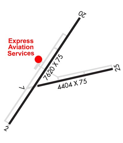
  • Runway Identifications
    Runway Identification: 02/20
    Length: 7615 ft
    Width: 75 ft
    Surface: ASPHALT
    Edge lights: Medium Intensity

    Treatment: NONE
    Weight: PCN 25 /F/D/X/T

     Runway: 02   Runway: 20
    Mag heading: 24°Mag heading: 204°
    Rwy Slope: .21% UpRwy Slope: -.21% Down
    Approach: Approach:
    Pattern: Left TrafficPattern: Left Traffic
    Markings: NONPRECISION INSTRUMENTMarkings: NONPRECISION INSTRUMENT
    Marking Condition: GOODMarking Condition: GOOD
    Arresting Dev: Arresting Dev:
    Lat & Long: N3644.1  W10430.7Lat. & Long.: N3645.1  W10429.8
    Elev: 6332.3 ft. MSLElev: 6348.6 ft. MSL
    TCH: 44 ft. AGLTCH:
    Visual Glide Path: 3.00 degreesVisual Glide Path:
    Displaced Threshold: NoDisplaced Threshold: No
    Touchdown Zone: YESTouchdown Zone: YES
    Touchdown Elev.: 6345.6 feetTouchdown Elev.: 6352.4 feet
    Visual Glide Slope: 2-Light PAPI on LEFT side of RunwayVisual Glide Slope:
    RVR Equipment: RVR Equipment:
    RVV Equipment: NORVV Equipment: NO
    Approach Lights: Approach Lights:
    REIL: NOREIL: NO
    Centerline Lights: NOCenterline Lights: NO
    Touchdown lights: NOTouchdown lights: NO
    Runway Category: Runway with a Non-precision Approach having visibility minimums greater than 3/4 mileRunway Category: Runway with a Visual Approach
    Declared Distances: Declared Distances:
    Runway Identification: 07/25
    Length: 4425 ft
    Width: 75 ft
    Surface: ASPHALT-GOOD CONDITION
    Edge lights: Medium Intensity

    Treatment: NONE
    Weight: PCN 6 /F/D/X/T

     Runway: 07   Runway: 25
    Mag heading: 68°Mag heading: 248°
    Rwy Slope: -.73% DownRwy Slope: .73% Up
    Approach: Approach:
    Pattern: Left TrafficPattern: Left Traffic
    Markings: BASICMarkings: NONPRECISION INSTRUMENT
    Marking Condition: GOODMarking Condition: GOOD
    Arresting Dev: Arresting Dev:
    Lat & Long: N3644.4  W10430.3Lat. & Long.: N3644.6  W10429.4
    Elev: 6342.0 ft. MSLElev: 6309.7 ft. MSL
    TCH: TCH:
    Visual Glide Path: Visual Glide Path:
    Displaced Threshold: NoDisplaced Threshold: No
    Touchdown Zone: YESTouchdown Zone: YES
    Touchdown Elev.: 6342.0 feetTouchdown Elev.: 6337.7 feet
    Visual Glide Slope: Visual Glide Slope:
    RVR Equipment: RVR Equipment:
    RVV Equipment: NORVV Equipment: NO
    Approach Lights: Approach Lights:
    REIL: NOREIL: NO
    Centerline Lights: NOCenterline Lights: NO
    Touchdown lights: NOTouchdown lights: NO
    Runway Category: Runway with a Visual ApproachRunway Category: Runway with a Non-precision Approach
    Declared Distances: Declared Distances:
    C:12/P: