Click here for more info on on SMS!

KRRQ

ROCK RAPIDS MUNI
ROCK RAPIDS
IA
Time Zone: Central
Lat: N 4327.1
Long: W 09610.8
Elev: 1363
Var: -05
Longest Runway: 3097
CTAF: 122.8

FBO & Flight Services info for KRRQ

FBOs: Update your Fuel Prices

CHAPIN ACFT RPRPh: 712-472-3332 Fax: 712-472-3332 Freq: 122.8
Service
Jet
100LL
SAF
MoGas
Fuel Avail: ~~Grade 100LL available. Must call ahead before landing.
Full        Last Update: 04/19/2024 00:01:44

Self        
If you are an FBO, call 1-203-262-1700 to update your info or email: FltPlan.Advertising@garmin.com
Advertise your FBO on FltPlan.com

Runway & Approach Info for KRRQ
Rwy
Length
Land Dist**
Approach*
  Rwy
Length
Land Dist**
Approach*
16
3097x50  2797'          
 
  
34
  3097x50  2797'          
 
 * only ILS, LOC, LDA, and SDF approaches to a specific runway are shown
** For any Declared Landing Distance Available, please see A/FD or Approach plates
Runway Weight Capability (lbs.) Help
Runway IDSingle WheelDouble WheelDouble Tandem WheelDual Double Wheel
16/348,000N/AN/AN/A
These numbers are Advisory and are not limits.   The Airport Manager should have more accurate Weight Limits
Approach Charts
Approaches    
Current Weather/Notams
Customs Information Send updates to Support@FltPlan.com
Customs Not Available
Database effective 04/18/2024
Airport Diagram of KRRQ
Airport Diagram might not be current.

Facility Name: ROCK RAPIDS MUNI
City Name: ROCK RAPIDS
County: LYON
State abbrev: IA
State Name: IOWA
   
Ownership: PUBLICLY OWNED
Use: OPEN TO THE PUBLIC
Owner's Name: CITY OF ROCK RAPIDS
Address: 411 FIRST AVENUE
 ROCK RAPIDS, IA 51246
Owner's Phone: 712-472-4585
  
Manager's Name: MICAH FREESE
Address: 411 FIRST AVENUE
 ROCK RAPIDS, IA 51246
Phone: 712-472-4585
   
FAA Region: CENTRAL
FAA Field Office: NONE


Sunrise / Sunset times for ROCK RAPIDS MUNI

DateSunriseSunset
04/18/24 Thursday6:3620:12
04/19/24 Friday6:3420:14
04/20/24 Saturday6:3320:15
04/21/24 Sunday6:3120:16
04/22/24 Monday6:3020:17
04/23/24 Tuesday6:2820:18
04/24/24 Wednesday6:2720:19
04/25/24 Thursday6:2520:21
04/26/24 Friday6:2420:22
04/27/24 Saturday6:2220:23
04/28/24 Sunday6:2120:24
04/29/24 Monday6:1920:25
04/30/24 Tuesday6:1820:27
05/01/24 Wednesday6:1620:28

Airport Facilities

Airport Attendance ScheduleMON-FRI 0900-1700, SAT 0900-1200; FOR AFTER HRS CALL (605) 988-4314.
Airport Status OPERATIONAL (This Status can change at any time - please check NOTAMS)
Airport Lighting ScheduleACTVT MIRL RY 16/34; PAPI RYS 16 & 34 - CTAF.
Airport Storage AvailableTie Downs, Hanger
Extra Services AvailableNONE
Wind IndicatorYES - (lighted)
Control TowerNO
CTAF Frequency122.800
Unicom Frequency122.800
Rotating Beacon ColorWG
Segmented CircleNO
Landing FeeNO

Airport Inspection Data

Airport InspectedSTATE - performed by STATE AERONAUTICAL PERSONNEL
Inspection Date10/15/2021

Airport Services

Type of Fuel AvailableGrade 100LL
Airframe Repair ServiceMAJOR
Power Plant Repair ServiceMAJOR

Geographic Data

LatitudeN4327.1
LongitudeW09610.8 (ESTIMATED)
Arpt Elevation1363ft (SURVEYED)
Magnetic Variation05E
2 miles NWof ROCK RAPIDS
Traffic Pattern Altitude
Sectional ChartOMAHA

Aircraft Data

Operations (Reported)YearlyAvg. Daily
General Aviation Transient 19895
General Aviation Local 15114
Air Taxi 00
Commerical 00
Commuter 00
Military 00
Aircraft based on Field
General Aviation Singles 16
General Aviation Multi 0
Jet Aircraft 0
General Aviation Helicopters 0
Military Aircraft 0
Gliders 0
Ultralights 0

FAA Services

FSS on field NO
FSS tie-in FORT DODGE
FSS Phone 1-800-WX-BRIEF
Who issues Notams FOD
Notam D service at airport YES
ARTCC Name MINNEAPOLIS

Federal Status

Airport Certification
Aircraft Rescue & Firefighting IndexNone
Airport of EntryNo
Custom Landing RightsNo
Joint Civil/MilitaryNo
Military Landing rightsYES

Federal Agreements

ASSURANCES PURSUANT TO TITLE VI, CIVIL RIGHTS ACT OF 1964
GRANT AGREEMENT HAS EXPIRED; HOWEVER, AGREEMENT REMAINS IN EFFECT FOR THIS FACILITY AS LONG AS IT IS PUBLIC USE.

Remarks

THIS AIRPORT HAS BEEN SURVEYED BY THE NATIONAL GEODETIC SURVEY.
RY 34 IS CALM WIND RY.
CAUTION: MIGRATORY WATERFOWL ADJ MOVEMENT AREAS.
FOR CD CTC SIOUX FALLS APCH AT 605-336-8602, WHEN APCH CLSD CTC MINNEAPOLIS ARTCC AT 651-463-5588.
Airport Communications & Frequencies:
CTAF Frequency:
122.800
Unicom Frequency:
122.800
Remarks
  • APCH/DEP SVC PRVDD BY MINNEAPOLIS ARTCC ON FREQS 132.050/317.4 (SIOUX FALLS RCAG) WHEN SIOUX FALLS APCH CTL IS CLSD.
  • SIOUX FALLS Primary Approach Frequencies:  
    126.9
    284.725
    SIOUX FALLS Primary Departure Frequencies:  
    126.9
    284.725
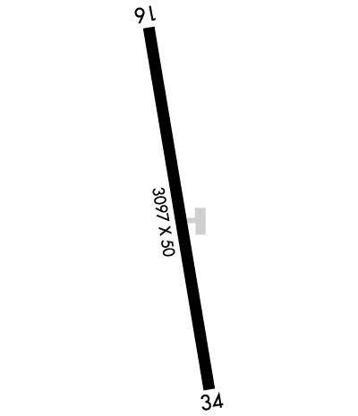
    Runway Identifications
    Runway Identification: 16/34
    Length: 3097 ft
    Width: 50 ft
    Surface: ASPHALT-FAIR CONDITION
    Edge lights: Medium Intensity

    Treatment: NONE

     Runway: 16   Runway: 34
    Mag heading: 167°Mag heading: 347°
    Rwy Slope: -.06% DownRwy Slope: .06% Up
    Approach: Approach:
    Pattern: Left TrafficPattern: Left Traffic
    Markings: NONPRECISION INSTRUMENTMarkings: NONPRECISION INSTRUMENT
    Marking Condition: FAIRMarking Condition: FAIR
    Arresting Dev: Arresting Dev:
    Lat & Long: N4327.4  W09610.8Lat. & Long.: N4326.9  W09610.7
    Elev: 1359.0 ft. MSLElev: 1357.0 ft. MSL
    TCH: 28 ft. AGLTCH: 29 ft. AGL
    Visual Glide Path: 3.00 degreesVisual Glide Path: 3.00 degrees
    Displaced Threshold: 300 feetDisplaced Threshold: 300 feet
    Touchdown Zone: YESTouchdown Zone: YES
    Touchdown Elev.: 1363.0 feetTouchdown Elev.: 1363.0 feet
    Visual Glide Slope: 2-Light PAPI on LEFT side of RunwayVisual Glide Slope: 2-Light PAPI on LEFT side of Runway
    RVR Equipment: RVR Equipment:
    RVV Equipment: NORVV Equipment: NO
    Approach Lights: Approach Lights:
    REIL: NOREIL: NO
    Centerline Lights: NOCenterline Lights: NO
    Touchdown lights: NOTouchdown lights: NO
    Runway Category: Runway with a Non-precision ApproachRunway Category: Runway with a Non-precision Approach
    Declared Distances: Declared Distances:
    Obstructions: TREEObstructions:
    Marked: NOT Marked/LightedMarked:
    Clearance slope: 17:1; CLNC 16:1 FROM DSPLCD THLD TO TREE.Clearance slope: 50:1; APCH SLOPE 26:1 TO DSPLCD THLD FM 16 FT ROAD 430 FT FM DSPLCD THLD L/R.
    Obstruction height: 51 feet AGLObstruction height:
    Dist. from runway: 1107 feetDist. from runway:
    Centerline offset: 284 left of centerlineCenterline offset:
    Comments: RY 16 +15 FT ROAD 155 FT DSTC ON CNTRLN.Comments: +16 FT ROAD 1 30 FT DSTC L/R.
    C:/P: