Current Weather/Notams (Metars, TAFs, Notams, NWS Forecast, PIREPS, and nearby weather)
Customs Information Send updates to Support@FltPlan.com
Customs Not Available
Database effective 05/16/2024
Airport Diagram might not be current. Facility Name: MERRILL MUNI City Name: MERRILL County: LINCOLN State abbrev: WI State Name: WISCONSIN Ownership: PUBLICLY OWNED Use: OPEN TO THE PUBLIC Owner's Name: CITY OF MERRILL Address: N2241 AIRPORT RD MERRILL, WI 54452 Owner's Phone: 715-536-2024 Manager's Name: RICH MCCULLOUGH Address: N2241 AIRPORT RD MERRILL, WI 54452 Phone: 715-536-2024 FAA Region: GREAT LAKES FAA Field Office: CHI
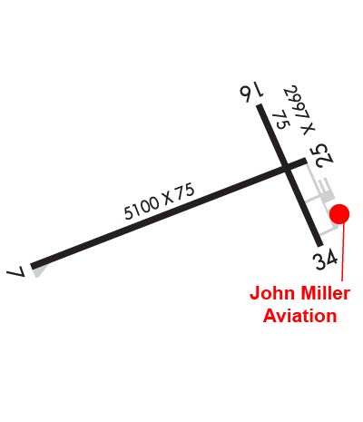
Runway Identifications Help
Runway Identification: 07/25 Length: 5100 ftWidth: 75 ftSurface: ASPHALT-GOOD CONDITIONEdge lights: Medium Intensity Treatment: NONE Runway: 07 Runway: 25 Mag heading: 70° Mag heading: 250° Rwy Slope: -.24% Down Rwy Slope: .24% Up Approach: Approach: Pattern: Left Traffic Pattern: Left Traffic Markings: NONPRECISION INSTRUMENT Markings: NONPRECISION INSTRUMENT Marking Condition: GOOD Marking Condition: GOOD Arresting Dev: Arresting Dev: Lat & Long: N4511.7 W08943.5 Lat. & Long.: N4512.1 W08942.4 Elev: 1318.2 ft. MSL Elev: 1306.2 ft. MSL TCH: 40 ft. AGL TCH: 40 ft. AGL Visual Glide Path: 3.00 degrees Visual Glide Path: 3.00 degrees Displaced Threshold: No Displaced Threshold: No Touchdown Zone: YES Touchdown Zone: YES Touchdown Elev.: 1318.2 feet Touchdown Elev.: 1310.5 feet Visual Glide Slope: 2-Light PAPI on LEFT side of Runway Visual Glide Slope: 2-Light PAPI on LEFT side of Runway RVR Equipment: RVR Equipment: RVV Equipment: NO RVV Equipment: NO Approach Lights: Approach Lights: REIL: YES REIL: YES Centerline Lights: NO Centerline Lights: NO Touchdown lights: NO Touchdown lights: NO Runway Category: Runway with a Non-precision Approach having visibility minimums greater than 3/4 mile Runway Category: Runway with a Non-precision Approach having visibility minimums greater than 3/4 mile Declared Distances: Declared Distances: Obstructions: TREES Obstructions: TREES Marked: NOT Marked/Lighted Marked: NOT Marked/Lighted Clearance slope: 25:1 Clearance slope: 23:1 Obstruction height: 55 feet AGL Obstruction height: 35 feet AGL Dist. from runway: 1600 feet Dist. from runway: 1025 feet Centerline offset: 230 right of centerline Centerline offset: 85 feet right of centerline Comments: Comments:
Runway Identification: 16/34 Length: 2997 ftWidth: 75 ftSurface: ASPHALT-FAIR CONDITIONEdge lights: Medium Intensity Treatment: NONE Runway: 16 Runway: 34 Mag heading: 158° Mag heading: 338° Rwy Slope: -.48% Down Rwy Slope: .48% Up Approach: Approach: Pattern: Left Traffic Pattern: Left Traffic Markings: BASIC Markings: BASIC Marking Condition: FAIR Marking Condition: FAIR Arresting Dev: Arresting Dev: Lat & Long: N4512.2 W08942.6 Lat. & Long.: N4511.8 W08942.3 Elev: 1317.8 ft. MSL Elev: 1303.4 ft. MSL TCH: TCH: Visual Glide Path: Visual Glide Path: Displaced Threshold: No Displaced Threshold: No Touchdown Zone: YES Touchdown Zone: YES Touchdown Elev.: 1317.8 feet Touchdown Elev.: 1317.8 feet Visual Glide Slope: Visual Glide Slope: RVR Equipment: RVR Equipment: RVV Equipment: NO RVV Equipment: NO Approach Lights: Approach Lights: REIL: NO REIL: NO Centerline Lights: NO Centerline Lights: NO Touchdown lights: NO Touchdown lights: NO Runway Category: Runway with a Visual Approach Runway Category: Runway with a Visual Approach Declared Distances: Declared Distances: Obstructions: Obstructions: TREES Marked: Marked: NOT Marked/Lighted Clearance slope: 20:1 Clearance slope: 18:1 Obstruction height: Obstruction height: 83 feet AGL Dist. from runway: Dist. from runway: 1775 feet Centerline offset: Centerline offset: 150 feet left of centerline Comments: Comments: