Current Weather/Notams (Metars, TAFs, Notams, NWS Forecast, PIREPS, and nearby weather)
Customs Information Send updates to Support@FltPlan.com
Customs Not Available
Database effective 05/16/2024
Airport Diagram might not be current. Facility Name: EL RENO RGNL City Name: EL RENO County: CANADIAN State abbrev: OK State Name: OKLAHOMA Ownership: PUBLICLY OWNED Use: OPEN TO THE PUBLIC Owner's Name: CITY OF EL RENO Address: PO BOX 700 EL RENO, OK 73036 Owner's Phone: 405-295-9343 Manager's Name: BAILEY FLAMING Address: PO BOX 700 EL RENO, OK 73036 Phone: 405-295-9343 FAA Region: SOUTHWEST FAA Field Office: AOK
Runway Identifications Help
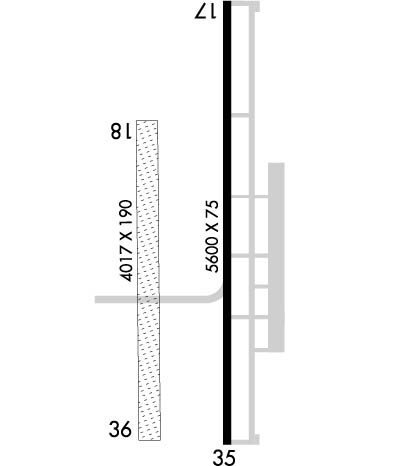
Runway Identification: 17/35 Length: 5600 ftWidth: 75 ftSurface: CONCRETE-GOOD CONDITIONEdge lights: Medium Intensity Treatment: NONE Runway: 17 Runway: 35 Mag heading: 176° Mag heading: 356° Rwy Slope: -.06% Down Rwy Slope: .06% Up Approach: Approach: Pattern: Left Traffic Pattern: Right Traffic Markings: NONPRECISION INSTRUMENT Markings: NONPRECISION INSTRUMENT Marking Condition: FAIR Marking Condition: FAIR Arresting Dev: Arresting Dev: Lat & Long: N3528.9 W09800.3 Lat. & Long.: N3527.9 W09800.3 Elev: 1420.4 ft. MSL Elev: 1416.9 ft. MSL TCH: 34 ft. AGL TCH: 34 ft. AGL Visual Glide Path: 2.00 degrees Visual Glide Path: 2.00 degrees Displaced Threshold: No Displaced Threshold: No Touchdown Zone: YES Touchdown Zone: YES Touchdown Elev.: 1420.4 feet Touchdown Elev.: 1417.0 feet Visual Glide Slope: 4-Light PAPI on LEFT side of Runway Visual Glide Slope: 4-Light PAPI on LEFT side of Runway RVR Equipment: RVR Equipment: RVV Equipment: NO RVV Equipment: NO Approach Lights: Approach Lights: REIL: YES REIL: YES Centerline Lights: NO Centerline Lights: NO Touchdown lights: NO Touchdown lights: NO Runway Category: Runway with a Non-precision Approach having visibility minimums greater than 3/4 mile Runway Category: Runway with a Non-precision Approach having visibility minimums greater than 3/4 mile Declared Distances: Declared Distances: Obstructions: PLINE Obstructions: ROAD Marked: MARKED Marked: NOT Marked/Lighted Clearance slope: 32:1 Clearance slope: 21:1 Obstruction height: 55 feet AGL Obstruction height: 12 feet AGL Dist. from runway: 1980 feet Dist. from runway: 460 feet Centerline offset: Centerline offset: Comments: Comments:
Runway Identification: 18/36 Length: 4017 ftWidth: 190 ftSurface: GRASS-FAIR CONDITIONEdge lights: Treatment: NONE Runway: 18 Runway: 36 Mag heading: 175° Mag heading: 355° Rwy Slope: .03% Up Rwy Slope: -.03% Down Approach: Approach: Pattern: Right Traffic Pattern: Left Traffic Markings: Markings: Marking Condition: Marking Condition: Arresting Dev: Arresting Dev: Lat & Long: N3528.6 W09800.5 Lat. & Long.: N3528.0 W09800.5 Elev: 1416.1 ft. MSL Elev: 1417.2 ft. MSL TCH: TCH: Visual Glide Path: Visual Glide Path: Displaced Threshold: No Displaced Threshold: No Touchdown Zone: YES Touchdown Zone: YES Touchdown Elev.: 1418.1 feet Touchdown Elev.: 1418.1 feet Visual Glide Slope: Visual Glide Slope: RVR Equipment: RVR Equipment: RVV Equipment: NO RVV Equipment: NO Approach Lights: Approach Lights: REIL: NO REIL: NO Centerline Lights: NO Centerline Lights: NO Touchdown lights: NO Touchdown lights: NO Runway Category: Runway with a Visual Approach Runway Category: Runway with a Visual Approach Declared Distances: Declared Distances: Obstructions: ROAD Obstructions: PLINE Marked: NOT Marked/Lighted Marked: NOT Marked/Lighted Clearance slope: 18:1 Clearance slope: 14:1 Obstruction height: 15 feet AGL Obstruction height: 25 feet AGL Dist. from runway: 280 feet Dist. from runway: 360 feet Centerline offset: 90 right of centerline Centerline offset: 95 feet left of centerline Comments: Comments: