Current Weather/Notams (Metars, TAFs, Notams, NWS Forecast, PIREPS, and nearby weather)
Customs Information Send updates to Support@FltPlan.com
Customs Not Available
Database effective 05/16/2024
Airport Diagram might not be current.
|
| Facility Name: | ROUNDUP |
| City Name: | ROUNDUP |
| County: | MUSSELSHELL |
| State abbrev: | MT |
| State Name: | MONTANA |
| | |
| Ownership: | PUBLICLY OWNED |
| Use: | OPEN TO THE PUBLIC |
| Owner's Name: | ROUNDUP & MUSSELSHELL COUNTY |
| Address: | 506 MAIN ST |
| | ROUNDUP, MT 59072 |
| Owner's Phone: | 406-323-1104 |
| | |
| Manager's Name: | KELLY GEBHARDT |
| Address: | 20 SKYLINE DRIVE |
| | ROUNDUP, MT 59072 |
| Phone: | 406-323-1564; OR 406-855-7354 CONTACT FOR SVCS |
| | |
| FAA Region: | NORTHWEST MOUNTAIN |
| FAA Field Office: | HLN |
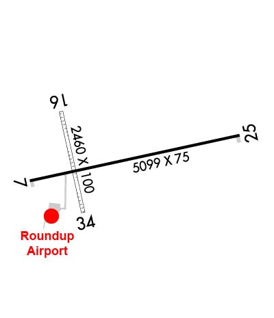
Runway Identifications
Runway Identification: 07/25Length: 5099 ft
Width: 75 ft
Surface: ASPHALT
Edge lights: Medium IntensityTreatment: NONE
| | Runway: 07 | | Runway: 25 |
| Mag heading: | 67° | Mag heading: | 247° |
| Rwy Slope: | -1.17% Down | Rwy Slope: | 1.17% Up |
| Approach: | | Approach: | |
| Pattern: | Left Traffic | Pattern: | Left Traffic; RY 25 RIGHT TFC FM 2200 TO 0700. |
| Markings: | NONPRECISION INSTRUMENT | Markings: | NONPRECISION INSTRUMENT |
| Marking Condition: | GOOD | Marking Condition: | GOOD |
| Arresting Dev: | | Arresting Dev: | |
| Lat & Long: | N4628.4 W10833.1 | Lat. & Long.: | N4628.6 W10831.9 |
| Elev: | 3490.3 ft. MSL | Elev: | 3430.8 ft. MSL |
| TCH: | 43 ft. AGL | TCH: | 42 ft. AGL |
| Visual Glide Path: | 4.00 degrees | Visual Glide Path: | 3.00 degrees |
| Displaced Threshold: | No | Displaced Threshold: | No |
| Touchdown Zone: | YES | Touchdown Zone: | YES |
| Touchdown Elev.: | 3490.3 feet | Touchdown Elev.: | 3453.3 feet |
| Visual Glide Slope: | 2-Light PAPI on LEFT side of Runway | Visual Glide Slope: | 2-Light PAPI on LEFT side of Runway |
| RVR Equipment: | | RVR Equipment: | |
| RVV Equipment: | NO | RVV Equipment: | NO |
| Approach Lights: | | Approach Lights: | |
| REIL: | NO | REIL: | NO |
| Centerline Lights: | NO | Centerline Lights: | NO |
| Touchdown lights: | NO | Touchdown lights: | NO |
| Runway Category: | Runway with a Non-precision Approach having visibility minimums greater than 3/4 mile | Runway Category: | Runway with a Non-precision Approach having visibility minimums greater than 3/4 mile |
| Declared Distances: | | Declared Distances: | |
| Obstructions: | GND | Obstructions: | |
| Marked: | NOT Marked/Lighted | Marked: | |
| Clearance slope: | 29:1 | Clearance slope: | 34:1 |
| Obstruction height: | 17 feet AGL | Obstruction height: | |
| Dist. from runway: | 700 feet | Dist. from runway: | |
| Centerline offset: | | Centerline offset: | |
| Comments: | | Comments: | |
Runway Identification: 16/34Length: 2460 ft
Width: 100 ft
Surface: GRASS-GOOD CONDITION
Edge lights: Treatment: NONE
| | Runway: 16 | | Runway: 34 |
| Mag heading: | 157° | Mag heading: | 337° |
| Rwy Slope: | .82% Up | Rwy Slope: | -.82% Down |
| Approach: | | Approach: | |
| Pattern: | Left Traffic | Pattern: | Left Traffic |
| Markings: | | Markings: | |
| Marking Condition: | RY 16/34 MKD WITH WHITE CONES FULL LENGTH; RED CONES MARK THR. | Marking Condition: | |
| Arresting Dev: | | Arresting Dev: | |
| Lat & Long: | N4628.7 W10832.9 | Lat. & Long.: | N4628.3 W10832.8 |
| Elev: | 3462.2 ft. MSL | Elev: | 3482.3 ft. MSL |
| TCH: | | TCH: | |
| Visual Glide Path: | | Visual Glide Path: | |
| Displaced Threshold: | No | Displaced Threshold: | No |
| Touchdown Zone: | YES | Touchdown Zone: | YES |
| Touchdown Elev.: | 3482.3 feet | Touchdown Elev.: | 3482.3 feet |
| Visual Glide Slope: | | Visual Glide Slope: | |
| RVR Equipment: | | RVR Equipment: | |
| RVV Equipment: | NO | RVV Equipment: | NO |
| Approach Lights: | | Approach Lights: | |
| REIL: | NO | REIL: | NO |
| Centerline Lights: | NO | Centerline Lights: | NO |
| Touchdown lights: | NO | Touchdown lights: | NO |
| Runway Category: | Runway with a Visual Approach | Runway Category: | Runway with a Visual Approach |
| Declared Distances: | | Declared Distances: | |