Current Weather/Notams (Metars, TAFs, Notams, NWS Forecast, PIREPS, and nearby weather)
Customs Information Send updates to Support@FltPlan.com
Customs Not Available
Database effective 04/18/2024
Airport Diagram might not be current.
|
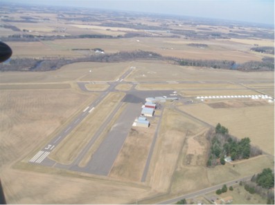
| Facility Name: | RICE LAKE RGNL/CARL'S FLD |
| City Name: | RICE LAKE |
| County: | BARRON |
| State abbrev: | WI |
| State Name: | WISCONSIN |
| | |
| Ownership: | PUBLICLY OWNED |
| Use: | OPEN TO THE PUBLIC |
| Owner's Name: | CITY OF RICE LAKE |
| Address: | CITY HALL |
| | RICE LAKE, WI 54868 |
| Owner's Phone: | 715-234-7800 |
| | |
| Manager's Name: | JOE ROBBINS |
| Address: | 1872 14 1/2 AVE |
| | CAMERON, WI 54822 |
| Phone: | (715) 458-4400 |
| | |
| FAA Region: | GREAT LAKES |
| FAA Field Office: | CHI |
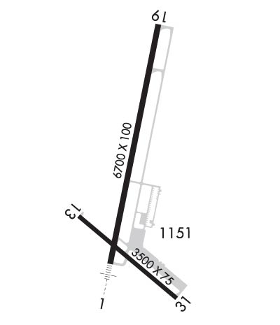
Runway Identifications
Runway Identification: 01/19Length: 6700 ft
Width: 100 ft
Surface: ASPHALT-FAIR CONDITION
Edge lights: High IntensityTreatment: NONE
| | Runway: 01 | | Runway: 19 |
| Mag heading: | 10° | Mag heading: | 190° |
| Rwy Slope: | .21% Up | Rwy Slope: | -.21% Down |
| Approach: | ILS | Approach: | |
| Pattern: | Right Traffic | Pattern: | Left Traffic |
| Markings: | PRECISION INSTRUMENT | Markings: | PRECISION INSTRUMENT |
| Marking Condition: | FAIR | Marking Condition: | FAIR |
| Arresting Dev: | | Arresting Dev: | |
| Lat & Long: | N4524.8 W09146.5 | Lat. & Long.: | N4525.9 W09146.2 |
| Elev: | 1095.0 ft. MSL | Elev: | 1109.1 ft. MSL |
| TCH: | 28 ft. AGL | TCH: | 38 ft. AGL |
| Visual Glide Path: | 3.00 degrees | Visual Glide Path: | 3.00 degrees |
| Displaced Threshold: | 200 feet | Displaced Threshold: | No |
| Touchdown Zone: | YES | Touchdown Zone: | YES |
| Touchdown Elev.: | 1102.1 feet | Touchdown Elev.: | 1109.2 feet |
| Visual Glide Slope: | 2-Light PAPI on LEFT side of Runway | Visual Glide Slope: | 4-Light PAPI on LEFT side of Runway |
| RVR Equipment: | | RVR Equipment: | |
| RVV Equipment: | NO | RVV Equipment: | NO |
| Approach Lights: | MALSR - 1,400 foot medium intensity approach lighting system with runway alignment indicator lights | Approach Lights: | |
| REIL: | NO | REIL: | YES |
| Centerline Lights: | NO | Centerline Lights: | NO |
| Touchdown lights: | NO | Touchdown lights: | NO |
| Runway Category: | Precision Instrument Runway | Runway Category: | D |
| Declared Distances: | | Declared Distances: | |
| Obstructions: | TREES | Obstructions: | |
| Marked: | NOT Marked/Lighted | Marked: | |
| Clearance slope: | 45:1; APCH RATIO 50:1 TO DSPLCD THR. | Clearance slope: | 34:1 |
| Obstruction height: | 68 feet AGL | Obstruction height: | |
| Dist. from runway: | 3300 feet | Dist. from runway: | |
| Centerline offset: | | Centerline offset: | |
| Comments: | | Comments: | |
Runway Identification: 13/31Length: 3500 ft
Width: 75 ft
Surface: ASPHALT-FAIR CONDITION
Edge lights: Medium IntensityTreatment: NONE
| | Runway: 13 | | Runway: 31 |
| Mag heading: | 130° | Mag heading: | 310° |
| Rwy Slope: | .21% Up | Rwy Slope: | -.21% Down |
| Approach: | | Approach: | |
| Pattern: | Left Traffic | Pattern: | Right Traffic |
| Markings: | NONPRECISION INSTRUMENT | Markings: | NONPRECISION INSTRUMENT |
| Marking Condition: | FAIR | Marking Condition: | FAIR |
| Arresting Dev: | | Arresting Dev: | |
| Lat & Long: | N4525.1 W09146.7 | Lat. & Long.: | N4524.7 W09146.1 |
| Elev: | 1092.1 ft. MSL | Elev: | 1099.5 ft. MSL |
| TCH: | 25 ft. AGL | TCH: | 40 ft. AGL |
| Visual Glide Path: | 3.75 degrees | Visual Glide Path: | 3.50 degrees |
| Displaced Threshold: | No | Displaced Threshold: | No |
| Touchdown Zone: | YES | Touchdown Zone: | YES |
| Touchdown Elev.: | 1098.3 feet | Touchdown Elev.: | 1099.6 feet |
| Visual Glide Slope: | 2-Light PAPI on LEFT side of Runway | Visual Glide Slope: | 2-Light PAPI on LEFT side of Runway |
| RVR Equipment: | | RVR Equipment: | |
| RVV Equipment: | NO | RVV Equipment: | NO |
| Approach Lights: | | Approach Lights: | |
| REIL: | YES | REIL: | YES |
| Centerline Lights: | NO | Centerline Lights: | NO |
| Touchdown lights: | NO | Touchdown lights: | NO |
| Runway Category: | Runway with a Visual Approach | Runway Category: | Runway with a Visual Approach |
| Declared Distances: | | Declared Distances: | |
| Obstructions: | TREES | Obstructions: | TREES |
| Marked: | NOT Marked/Lighted | Marked: | NOT Marked/Lighted |
| Clearance slope: | 6:1 | Clearance slope: | 15:1 |
| Obstruction height: | 22 feet AGL | Obstruction height: | 72 feet AGL |
| Dist. from runway: | 345 feet | Dist. from runway: | 1320 feet |
| Centerline offset: | 130 right of centerline | Centerline offset: | 210 feet left of centerline |
| Comments: | | Comments: | |