Current Weather/Notams (Metars, TAFs, Notams, NWS Forecast, PIREPS, and nearby weather)
Customs Information Send updates to Support@FltPlan.com
Customs Not Available
Database effective 05/16/2024
Airport Diagram might not be current.
|
| Facility Name: | ROSEAU MUNI/RUDY BILLBERG FLD |
| City Name: | ROSEAU |
| County: | ROSEAU |
| State abbrev: | MN |
| State Name: | MINNESOTA |
| | |
| Ownership: | PUBLICLY OWNED |
| Use: | OPEN TO THE PUBLIC |
| Owner's Name: | CITY OF ROSEAU |
| Address: | 121 CENTER ST E, STE 202, PO BOX 307 |
| | ROSEAU, MN 56751-0307 |
| Owner's Phone: | 218-463-1542 |
| | |
| Manager's Name: | TODD PETERSON |
| Address: | 121 CENTER ST E, PO BOX 307 |
| | ROSEAU, MN 56751-0307 |
| Phone: | 218-689-0047 |
| | |
| FAA Region: | GREAT LAKES |
| FAA Field Office: | DMA |
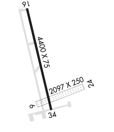
Runway Identifications
Runway Identification: 06/24Length: 2097 ft
Width: 250 ft
Surface: GRASS-GOOD CONDITION
Edge lights: Treatment: NONE
| | Runway: 06 | | Runway: 24 |
| Mag heading: | 67° | Mag heading: | 247° |
| Rwy Slope: | -.07% Down | Rwy Slope: | .07% Up |
| Approach: | | Approach: | |
| Pattern: | Left Traffic | Pattern: | Left Traffic |
| Markings: | NONE | Markings: | NONE |
| Marking Condition: | | Marking Condition: | |
| Arresting Dev: | | Arresting Dev: | |
| Lat & Long: | N4851.1 W09541.9 | Lat. & Long.: | N4851.3 W09541.4 |
| Elev: | 1057.8 ft. MSL | Elev: | 1056.3 ft. MSL |
| TCH: | | TCH: | |
| Visual Glide Path: | | Visual Glide Path: | |
| Displaced Threshold: | No | Displaced Threshold: | No |
| Touchdown Zone: | YES | Touchdown Zone: | YES |
| Touchdown Elev.: | 1060.0 feet | Touchdown Elev.: | 1060.0 feet |
| Visual Glide Slope: | | Visual Glide Slope: | |
| RVR Equipment: | | RVR Equipment: | |
| RVV Equipment: | NO | RVV Equipment: | NO |
| Approach Lights: | | Approach Lights: | |
| REIL: | NO | REIL: | NO |
| Centerline Lights: | NO | Centerline Lights: | NO |
| Touchdown lights: | NO | Touchdown lights: | NO |
| Runway Category: | Runway with a Visual Approach | Runway Category: | Runway with a Visual Approach |
| Declared Distances: | | Declared Distances: | |
Runway Identification: 16/34Length: 4400 ft
Width: 75 ft
Surface: ASPHALT-FAIR CONDITION
Edge lights: Medium IntensityTreatment: NONE
| | Runway: 16 | | Runway: 34 |
| Mag heading: | 164° | Mag heading: | 344° |
| Rwy Slope: | .32% Up | Rwy Slope: | -.32% Down |
| Approach: | | Approach: | |
| Pattern: | Left Traffic | Pattern: | Left Traffic |
| Markings: | NONPRECISION INSTRUMENT | Markings: | NONPRECISION INSTRUMENT |
| Marking Condition: | GOOD | Marking Condition: | GOOD |
| Arresting Dev: | | Arresting Dev: | |
| Lat & Long: | N4851.8 W09542.0 | Lat. & Long.: | N4851.1 W09541.8 |
| Elev: | 1046.0 ft. MSL | Elev: | 1060.0 ft. MSL |
| TCH: | 44 ft. AGL | TCH: | 44 ft. AGL |
| Visual Glide Path: | 3.00 degrees | Visual Glide Path: | 3.00 degrees |
| Displaced Threshold: | No | Displaced Threshold: | No |
| Touchdown Zone: | YES | Touchdown Zone: | YES |
| Touchdown Elev.: | 1055.3 feet | Touchdown Elev.: | 1060.3 feet |
| Visual Glide Slope: | 2-Light PAPI on LEFT side of Runway | Visual Glide Slope: | 2-Light PAPI on LEFT side of Runway |
| RVR Equipment: | | RVR Equipment: | |
| RVV Equipment: | NO | RVV Equipment: | NO |
| Approach Lights: | MALSF - 1,400 foot medium intensity approach lighting system with sequenced flashers | Approach Lights: | |
| REIL: | NO | REIL: | YES; REIL NSTD DUE TO PCL 7 CLICKS ON, NO 3 OR 5 CLICK OPRN. |
| Centerline Lights: | NO | Centerline Lights: | NO |
| Touchdown lights: | NO | Touchdown lights: | NO |
| Runway Category: | D | Runway Category: | D |
| Declared Distances: | | Declared Distances: | |
| Obstructions: | SEASONAL. | Obstructions: | |
| Marked: | NOT Marked/Lighted | Marked: | |
| Clearance slope: | 34:1 | Clearance slope: | 34:1 |
| Obstruction height: | | Obstruction height: | |
| Dist. from runway: | | Dist. from runway: | |
| Centerline offset: | | Centerline offset: | |
| Comments: | | Comments: | |

