Click here for more info on on SMS!

KROW

ROSWELL INTL AIR CENTER
ROSWELL
NM
Time Zone: Mountain
Lat: N 3318.0
Long: W 10431.8
Elev: 3671
Var: -10
Longest Runway: 13000
Clr Del: 132.87
Dept. ATIS: 128.45
Arr. ATIS: 128.45
Ground: 121.9
Tower: 118.5

FBO & Flight Services info for KROW

FBOs: Update your Fuel Prices

AVFLIGHTPh: 575-347-2054 Fax: 575-347-2431 Freq: 122.95
Service
Jet
100LL
SAF
MoGas
Full7.196.90    Last Update: 04/09/2024 12:35
PRICES GUARANTEED by FBO.
Self        
 Address: PO BOX 5700   ROSWELL, NM 88202
ASOSPh: 575-347-0040
-
-
 
If you are an FBO, call 1-203-262-1700 to update your info or email: FltPlan.Advertising@garmin.com
Advertise your FBO on FltPlan.com

Runway & Approach Info for KROW
Rwy
Length
Land Dist**
Approach*
  Rwy
Length
Land Dist**
Approach*
03
13000x150  13000'          
 
  
21
  13000x150  13000'          
ILS/DME
 109.90 - 215°  
17
10008x100  10008'          
 
  
35
  10008x100  10008'          
 
 * only ILS, LOC, LDA, and SDF approaches to a specific runway are shown
** For any Declared Landing Distance Available, please see A/FD or Approach plates
Runway Weight Capability (lbs.) Help
Runway IDSingle WheelDouble WheelDouble Tandem WheelDual Double Wheel
03/21100,000200,000400,000N/A
17/3577,000104,000165,000N/A
These numbers are Advisory and are not limits.   The Airport Manager should have more accurate Weight Limits
Approach Charts
Approaches    
Current Weather/Notams
Customs Information Send updates to Support@FltPlan.com
Customs Not Available
Database effective 04/18/2024
Airport Diagram of KROW
Airport Diagram might not be current.

Facility Name: ROSWELL AIR CENTER
City Name: ROSWELL
County: CHAVES
State abbrev: NM
State Name: NEW MEXICO
   
Ownership: PUBLICLY OWNED
Use: OPEN TO THE PUBLIC
Owner's Name: CITY OF ROSWELL
Address: 425 N RICHARDSON
 ROSWELL, NM 88201
Owner's Phone: 575-624-6700
  
Manager's Name: SCOTT STARK
Address: 1 JERRY SMITH CIRCLE
 ROSWELL, NM 88203
Phone: 575-347-5703
   
FAA Region: SOUTHWEST
FAA Field Office: LNM


Sunrise / Sunset times for ROSWELL AIR CENTER

DateSunriseSunset
04/17/24 Wednesday6:2519:31
04/18/24 Thursday6:2319:32
04/19/24 Friday6:2219:32
04/20/24 Saturday6:2119:33
04/21/24 Sunday6:2019:34
04/22/24 Monday6:1919:35
04/23/24 Tuesday6:1819:35
04/24/24 Wednesday6:1719:36
04/25/24 Thursday6:1619:37
04/26/24 Friday6:1419:38
04/27/24 Saturday6:1319:38
04/28/24 Sunday6:1219:39
04/29/24 Monday6:1119:40
04/30/24 Tuesday6:1019:41

Airport Facilities

Airport Attendance Schedule7 Days A Week 0600-2100; AFT HR - 575-347-2054 OR 575-626-3697.
Airport Status OPERATIONAL (This Status can change at any time - please check NOTAMS)
Airport Lighting ScheduleACTVT MALSR RWY 21; MIRL RWY 17/35 - CTAF. VASI RWY 03; PAPI RWY 17 & 35 - ON CONSLY. WHEN ATCT CLSD MIRL RWY 03/21 ON MED INTST.
Airport Storage AvailableTie Downs, Hanger
Extra Services AvailableAir Freight, Air Ambulance, Flight Instruction
Wind IndicatorYES - (lighted)
Control TowerYES
CTAF Frequency118.500
Unicom Frequency122.950
Rotating Beacon ColorWG
Segmented CircleYES
Landing FeeNO

Airport Inspection Data

Airport InspectedFEDERAL - performed by FAA AIRPORTS FIELD PERSONNEL
Inspection Date04/25/2019

Airport Services

Type of Fuel AvailableGrade 100LL, JET A (freeze point -40C), JET A-1 (icing inhibitor, freeze point -50C); -10AFT HR - 575-347-2054.
Airframe Repair ServiceMINOR
Power Plant Repair ServiceMINOR

Geographic Data

LatitudeN3318.0
LongitudeW10431.8 (ESTIMATED)
Arpt Elevation3671ft (SURVEYED)
Magnetic Variation10E
3 miles Sof ROSWELL
Traffic Pattern Altitude
Sectional ChartALBUQUERQUE

Aircraft Data

Operations (Reported)YearlyAvg. Daily
General Aviation Transient 818922
General Aviation Local 21756
Air Taxi 21696
Commerical 22976
Commuter 00
Military 1286035
Aircraft based on Field
General Aviation Singles 22
General Aviation Multi 9
Jet Aircraft 5
General Aviation Helicopters 2
Military Aircraft 0
Gliders 0
Ultralights 0

FAA Services

FSS on field NO
FSS tie-in ALBUQUERQUE
FSS Phone 1-800-WX-BRIEF
Who issues Notams ROW
Notam D service at airport YES
ARTCC Name ALBUQUERQUE

Federal Status

Airport CertificationAIRPORT RECEIVING SCHEDULED AIR CARRIER SERVICE FROM CARRIERS CERTIFICATED BY THE CIVIL AERONAUTICS BOARD
Aircraft Rescue & Firefighting IndexAIRPORT HAS A CERTIFICATE UNDER CFR PART 139
Airport of EntryNo
Custom Landing RightsYES
Joint Civil/MilitaryNo
Military Landing rightsYES

Federal Agreements

NATIONAL PLAN OF INTEGRATED AIRPORT SYSTEMS (NPIAS)
GRANT AGREEMENTS UNDER FAAP/ADAP/AIP
SURPLUS PROPERTY AGREEMENT UNDER PUBLIC LAW 289
ASSURANCES PURSUANT TO TITLE VI, CIVIL RIGHTS ACT OF 1964

Remarks

TO EXIT RAMP/FBO AREA AFT HR USE LGTD PEDESTRIAN GATE; TO ENTER GATE: 575-347-2054.
BIRDS ON & INVOF ARPT.
LRG ACFT LONG TERM STORAGE AVBL.
FOR CD IF UNA TO CTC ON FSS FREQ, CTC ALBUQUERQUE ARTCC AT 505-856-4561.
RWY 03/2 1 NSTD MIRL 75 FT FM RWY EDGE.
Airport Communications & Frequencies:
ATIS Frequencies:   Hours(local) of Operation: CONTINUOUS
128.45
306.2
ROSWELL Tower Frequencies:   Hours(local) of operation: 0600-2100   
118.5
233.7
ROSWELL Ground Frequencies:
121.9
348.6
Clearance Delivery Frequencies:
132.875
282.25
Emergency Frequencies:
121.5
243.0
CTAF Frequency:
118.500
Unicom Frequency:
122.950
Remarks
  • APCH/DEP SVC PRVDD BY ALBUQUERQUE ARTCC (ZAB) ON FREQS 132.65/257.6 (ROSWELL RCAG) WHEN ROSWELL APCH CTL (ROW) CLSD.
  • ROSWELL Primary Approach Frequencies:   Hours(local) of operation: 0600-2100   
    119.6 ;EAST OF V291
    120.35 ;WEST OF V291
    229.4 ;WEST OF V291
    239.0 ;EAST OF V291
    ROSWELL Primary Departure Frequencies:   Hours(local) of operation: 0600-2100   
    119.6 ;EAST OF V291
    120.35 ;WEST OF V291
    229.4 ;WEST OF V291
    239.0 ;EAST OF V291
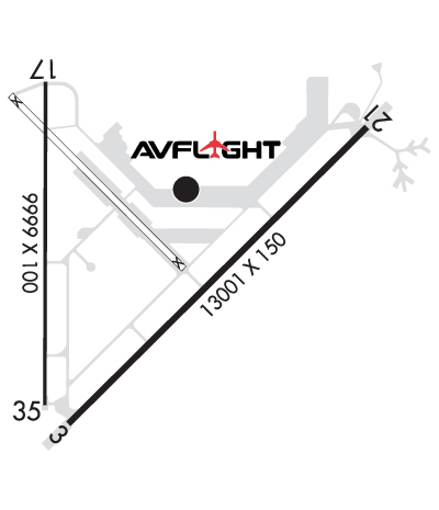
    Runway Identifications
    Runway Identification: 03/21
    Length: 13000 ft
    Width: 150 ft
    Surface: CONCRETE
    Edge lights: Medium Intensity

    Treatment: NONE
    Weight: PCN 115/R/C/W/T

     Runway: 03   Runway: 21
    Mag heading: 35°Mag heading: 215°
    Rwy Slope: -.33% DownRwy Slope: .33% Up
    Approach: Approach: ILS/DME
    Pattern: Right TrafficPattern: Left Traffic
    Markings: NONPRECISION INSTRUMENTMarkings: PRECISION INSTRUMENT
    Marking Condition: GOODMarking Condition: GOOD
    Arresting Dev: Arresting Dev:
    Lat & Long: N3317.2  W10432.2Lat. & Long.: N3318.7  W10430.4
    Elev: 3667.2 ft. MSLElev: 3623.7 ft. MSL
    TCH: 48 ft. AGLTCH:
    Visual Glide Path: 3.00 degreesVisual Glide Path:
    Displaced Threshold: NoDisplaced Threshold: No
    Touchdown Zone: YESTouchdown Zone: YES
    Touchdown Elev.: 3667.2 feetTouchdown Elev.: 3633.3 feet
    Visual Glide Slope: 6-BOX VASI ON LEFT SIDE OF RUNWAYVisual Glide Slope:
    RVR Equipment: RVR Equipment:
    RVV Equipment: NORVV Equipment: NO
    Approach Lights: Approach Lights: MALSR - 1,400 foot medium intensity approach lighting system with runway alignment indicator lights
    REIL: NOREIL: NO
    Centerline Lights: NOCenterline Lights: NO
    Touchdown lights: NOTouchdown lights: NO
    Runway Category: Runway with a Non-precision Approach having visibility minimums greater than 3/4 mileRunway Category: Precision Instrument Runway
    Declared Distances: TORA:13000' TODA:13000' ASDA:13000' LDA:13000'Declared Distances: TORA:13000' TODA:13000' ASDA:13000' LDA:13000'
    Runway Identification: 17/35
    Length: 10008 ft
    Width: 100 ft
    Surface: ASPHALT-GOOD CONDITION
    Edge lights: Medium Intensity

    Treatment: GROOVED
    Weight: PCN 15 /R/C/X/T

     Runway: 17   Runway: 35
    Mag heading: 170°Mag heading: 350°
    Rwy Slope: .09% UpRwy Slope: -.09% Down
    Approach: Approach:
    Pattern: Right TrafficPattern: Left Traffic
    Markings: PRECISION INSTRUMENTMarkings: PRECISION INSTRUMENT
    Marking Condition: GOODMarking Condition: GOOD
    Arresting Dev: Arresting Dev:
    Lat & Long: N3318.9  W10432.4Lat. & Long.: N3317.3  W10432.4
    Elev: 3662.4 ft. MSLElev: 3671.0 ft. MSL
    TCH: 49 ft. AGLTCH: 49 ft. AGL
    Visual Glide Path: 3.00 degreesVisual Glide Path: 3.00 degrees
    Displaced Threshold: NoDisplaced Threshold: No
    Touchdown Zone: YESTouchdown Zone: YES
    Touchdown Elev.: 3666.2 feetTouchdown Elev.: 3671.0 feet
    Visual Glide Slope: 4-Light PAPI on LEFT side of Runway; PAPI UNUSBL BYD 8 DEG RIGHT OF CNTRLN.Visual Glide Slope: 4-Light PAPI on LEFT side of Runway
    RVR Equipment: RVR Equipment:
    RVV Equipment: NORVV Equipment: NO
    Approach Lights: Approach Lights:
    REIL: NOREIL: NO
    Centerline Lights: NOCenterline Lights: NO
    Touchdown lights: NOTouchdown lights: NO
    Runway Category: Runway with a Visual ApproachRunway Category: Runway with a Non-precision Approach having visibility minimums greater than 3/4 mile
    Declared Distances: TORA:10008' TODA:10008' ASDA:10008' LDA:10008'Declared Distances: TORA:10008' TODA:10008' ASDA:10008' LDA:10008'
    C:34/P: