Current Weather/Notams (Metars, TAFs, Notams, NWS Forecast, PIREPS, and nearby weather)
Customs Information Send updates to Support@FltPlan.com
Customs Not Available
Database effective 04/18/2024
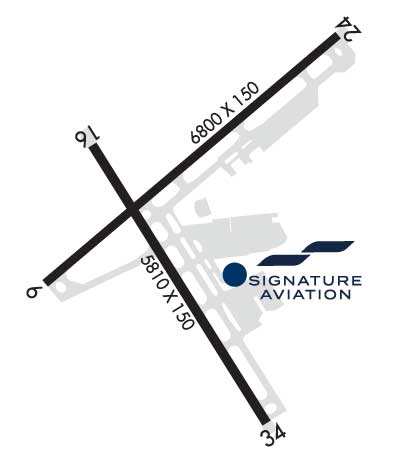
Airport Diagram might not be current. Facility Name: ROANOKE/BLACKSBURG RGNL (WOODRUM FLD) City Name: ROANOKE County: ROANOKE State abbrev: VA State Name: VIRGINIA Ownership: PUBLICLY OWNED Use: OPEN TO THE PUBLIC Owner's Name: ROANOKE BLACKSBURG RGNL/WOODRUM FIE Address: 5202 AVN DR. ROANOKE, VA 24012-1148 Owner's Phone: 540 362-1999 Manager's Name: MIKE STEWART Address: 5202 AVN DR. ROANOKE, VA 24012-1148 Phone: 540-362-1999 FAA Region: EASTERN FAA Field Office: DCA
Runway Identifications Help
Runway Identification: 06/24 Length: 6800 ftWidth: 150 ftSurface: ASPHALT-GOOD CONDITIONEdge lights: High Intensity Treatment: GROOVEDWeight: PCN 76 /F/B/X/T Runway: 06 Runway: 24 Mag heading: 57° Mag heading: 237° Rwy Slope: -.02% Down Rwy Slope: .02% Up Approach: LDA/DME Approach: Pattern: Left Traffic Pattern: Left Traffic Markings: PRECISION INSTRUMENT Markings: NONPRECISION INSTRUMENT Marking Condition: GOOD Marking Condition: GOOD Arresting Dev: Arresting Dev: Lat & Long: N3719.3 W07959.0 Lat. & Long.: N3720.1 W07958.0 Elev: 1152.0 ft. MSL Elev: 1150.7 ft. MSL TCH: 58 ft. AGL TCH: 58 ft. AGL Visual Glide Path: 3.00 degrees Visual Glide Path: 3.00 degrees Displaced Threshold: No Displaced Threshold: 790 feet Touchdown Zone: YES Touchdown Zone: YES Touchdown Elev.: 1175.2 feet Touchdown Elev.: 1170.3 feet Visual Glide Slope: 4-BOX VASI ON LEFT SIDE OF RUNWAY Visual Glide Slope: 4-Light PAPI on LEFT side of Runway; PAPI UNUSBL BYD 5 DEGS R OF CNTRLN DUE TO TRRN. RVR Equipment: RVR Equipment: RVV Equipment: NO RVV Equipment: NO Approach Lights: MALSR - 1,400 foot medium intensity approach lighting system with runway alignment indicator lights Approach Lights: REIL: YES REIL: YES Centerline Lights: NO Centerline Lights: NO Touchdown lights: NO Touchdown lights: NO Runway Category: D Runway Category: Runway with a Non-precision Approach having visibility minimums greater than 3/4 mile Declared Distances: TORA:6800' TODA:6800' ASDA:6800' LDA:6800' Declared Distances: TORA:6800' TODA:6800' ASDA:6800' LDA:6010'
Runway Identification: 16/34 Length: 5810 ftWidth: 150 ftSurface: ASPHALT-GOOD CONDITIONEdge lights: High Intensity Treatment: GROOVEDWeight: PCN 54 /F/A/X/T Runway: 16 Runway: 34 Mag heading: 156° Mag heading: 336° Rwy Slope: -.39% Down Rwy Slope: .39% Up Approach: Approach: ILS Pattern: Left Traffic Pattern: Left Traffic Markings: NONPRECISION INSTRUMENT Markings: PRECISION INSTRUMENT Marking Condition: GOOD Marking Condition: GOOD Arresting Dev: Arresting Dev: EMAS; ENGINEERED MATERIALS ARRESTING SYSTEM (EMAS) 299 FT IN LENGTH BY 169 FT IN WIDTH LCTD AT DER 34. Lat & Long: N3719.7 W07958.9 Lat. & Long.: N3718.9 W07958.2 Elev: 1165.6 ft. MSL Elev: 1142.9 ft. MSL TCH: TCH: 56 ft. AGL Visual Glide Path: Visual Glide Path: 3.00 degrees Displaced Threshold: No Displaced Threshold: No Touchdown Zone: YES Touchdown Zone: YES Touchdown Elev.: 1173.3 feet Touchdown Elev.: 1160.1 feet Visual Glide Slope: Visual Glide Slope: 4-Light PAPI on LEFT side of Runway RVR Equipment: RVR Equipment: RVV Equipment: NO RVV Equipment: NO Approach Lights: Approach Lights: MALSR - 1,400 foot medium intensity approach lighting system with runway alignment indicator lights REIL: NO REIL: NO Centerline Lights: NO Centerline Lights: NO Touchdown lights: NO Touchdown lights: NO Runway Category: Runway with a Visual Approach Runway Category: Precision Instrument Runway Declared Distances: TORA:5810' TODA:5810' ASDA:5810' LDA:5810' Declared Distances: TORA:5810' TODA:5810' ASDA:5810' LDA:5810' Obstructions: Obstructions: TOWER Marked: Marked: LIGHTED Clearance slope: 50:1 Clearance slope: 30:1 Obstruction height: Obstruction height: 837 feet AGL Dist. from runway: Dist. from runway: 26070 feet Centerline offset: Centerline offset: Comments: Comments: