
| ||||||||||||||||||||||||||||||||||||||||||||
| ||||||||||||||||||||||||||||||||||||||||||||
| ||||||||||||||||||||||||||||||||||||||||||||
| ||||||||||||||||||||||||||||||||||||||||||||
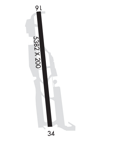
| Rwy | Rwy | |||||||
| 5382x200 | 5078' | 5382x200 | 5042' | |||||
| Runway ID | Single Wheel | Double Wheel | Double Tandem Wheel | Dual Double Wheel |
| 16/34 | 100,000 | 130,000 | 340,000 | N/A |
| These numbers are Advisory and are not limits. The Airport Manager should have more accurate Weight Limits | ||||
 Airport Diagram might not be current. | |
| Facility Name: | RENTON MUNI |
| City Name: | RENTON |
| County: | KING |
| State abbrev: | WA |
| State Name: | WASHINGTON |
| Ownership: | PUBLICLY OWNED |
| Use: | OPEN TO THE PUBLIC |
| Owner's Name: | CITY OF RENTON |
| Address: | 1055 SOUTH GRADY WAY |
| RENTON, WA 98055 | |
| Owner's Phone: | 425-430-6400 |
| Manager's Name: | WILLIAM ADAMS |
| Address: | 616 WEST PERIMETER ROAD, UNIT A; AIRPORT ADMINISTRATION OFFICE IN AIRPORT TRAFFIC CONTROL TOWER. |
| RENTON, WA 98057 | |
| Phone: | 206-775-6862 |
| FAA Region: | NORTHWEST MOUNTAIN |
| FAA Field Office: | SEA |

| Date | Sunrise | Sunset |
|---|---|---|
| 04/18/24 Thursday | 6:13 | 20:04 |
| 04/19/24 Friday | 6:11 | 20:05 |
| 04/20/24 Saturday | 6:09 | 20:07 |
| 04/21/24 Sunday | 6:08 | 20:08 |
| 04/22/24 Monday | 6:06 | 20:09 |
| 04/23/24 Tuesday | 6:04 | 20:11 |
| 04/24/24 Wednesday | 6:02 | 20:12 |
| 04/25/24 Thursday | 6:01 | 20:14 |
| 04/26/24 Friday | 5:59 | 20:15 |
| 04/27/24 Saturday | 5:57 | 20:16 |
| 04/28/24 Sunday | 5:55 | 20:18 |
| 04/29/24 Monday | 5:54 | 20:19 |
| 04/30/24 Tuesday | 5:52 | 20:21 |
| 05/01/24 Wednesday | 5:51 | 20:22 |
| Airport Attendance Schedule | 7 Days A Week 0700-DUSK |
| Airport Status | OPERATIONAL (This Status can change at any time - please check NOTAMS) |
| Airport Lighting Schedule | ACTVT REIL RWY 16 & 34; MIRL RWY 16/34 AND TWY LGTS - CTAF. |
| Airport Storage Available | Tie Downs |
| Extra Services Available | Avionics, Beaching Gear, Charter, Flight Instruction, Aircraft Rental |
| Wind Indicator | YES - (lighted) |
| Control Tower | YES |
| CTAF Frequency | 124.700 |
| Unicom Frequency | 122.950; ACFT REQUIRING SVCS CTC 122.85 OR 122.77. |
| Rotating Beacon Color | WG |
| Segmented Circle | NO |
| Landing Fee | NO |
| Airport Inspected | STATE - performed by STATE AERONAUTICAL PERSONNEL |
| Inspection Date | 06/29/2021 |
| Type of Fuel Available | Grade 100LL, JET A (freeze point -40C), JET A; -10SELF SERVE FUEL NOT AVBL. |
| Airframe Repair Service | MAJOR |
| Power Plant Repair Service | MAJOR |
| Latitude | N4729.6 |
| Longitude | W12212.9 (ESTIMATED) |
| Arpt Elevation | 32ft (SURVEYED) |
| Magnetic Variation | 17E |
| 0 miles NW | of RENTON |
| Traffic Pattern Altitude | 1218; TPA WEST OF THE FIELD IS 1218 FT AGL DUE TO TERRAIN IMMEDIATELY WEST OF THE ARPT. |
| Sectional Chart | SEATTLE |
| Operations (Reported) | Yearly | Avg. Daily |
|---|---|---|
| General Aviation Transient | 50032 | 137 |
| General Aviation Local | 79775 | 219 |
| Air Taxi | 2136 | 6 |
| Commerical | 148 | 0 |
| Commuter | 0 | 0 |
| Military | 372 | 1 |
| Aircraft based on Field | |
|---|---|
| General Aviation Singles | 248 |
| General Aviation Multi | 18 |
| Jet Aircraft | 7 |
| General Aviation Helicopters | 7 |
| Military Aircraft | 0 |
| Gliders | 0 |
| Ultralights | 0 |
| FSS on field | NO |
| FSS tie-in | SEATTLE |
| FSS Phone | 1-800-WX-BRIEF |
| Who issues Notams | RNT |
| Notam D service at airport | YES |
| ARTCC Name | SEATTLE |
| Airport Certification | |
| Aircraft Rescue & Firefighting Index | None |
| Airport of Entry | No |
| Custom Landing Rights | YES |
| Joint Civil/Military | No |
| Military Landing rights | YES |
| NATIONAL PLAN OF INTEGRATED AIRPORT SYSTEMS (NPIAS) |
| GRANT AGREEMENTS UNDER FAAP/ADAP/AIP |
| SURPLUS PROPERTY AGREEMENT UNDER PUBLIC LAW 289 |
| ASSURANCES PURSUANT TO TITLE VI, CIVIL RIGHTS ACT OF 1964 |
| RY 34 12 FT BLAST FENCE 155 FT FROM END OF RY. |
| TWY B BETWEEN TWY B3 AND TWY B5 CLSD TO ACFT WITH WING SPAN 50 FT OR OVER. |
| EMERG FREQ 121.5 NOT MNT AT TWR. |
| DRNG RNT TWR HRS OF OPR AND VMC WX, RNT TWR HAS CNTL OF THE WEST CHANNEL, OVER THE WATER, AT AND BLO 800 FT AGL. IF OPR IN THE WEST CHANNEL ABV 800 FT AGL OR OUTSIDE OF RNT TWR OPR HOURS, CTC BOEING TWR, 118.3, PRIOR TO OPR IN THE WEST CHANNEL. |
| FOR CD WHEN ATCT IS CLSD CTC SEATTLE APCH AT 206-214-4722. |
| NUMEROUS FLOCKS OF BIRDS INVOF ARPT & ALONG LAKE WASHINGTON SHORELINE AT ALL TIMES. |
| WEST TWY CLSD TO ACFT WITH WING SPAN 118 FT OR OVER. |
| FLIGHT NOTIFICATION SERVICE (ADCUS) AVBL. |
| BE ALERT FOR BOEING PRODUCTION ACFT BEING TOWED ACROSS THE RY DURG HRS ATCT CLOSED. |
| NOISE ABATEMENT PROCEDURES IN EFFECT CTC ADMIN 425-430-7471. |
| SEAPLANE BASE NW CORNER ARPT. |
Airport Communications & Frequencies:
| |||||||||||||||||||||||||||||||||||||||||||||||||||||||||||||||||||||||||||||||||||||||||||||||||||||||||||||||||||||||||||||||||||||||||||||||
| Runway: 16 | Runway: 34 | ||
| Mag heading: | 157° | Mag heading: | 337° |
| Rwy Slope: | .15% Up | Rwy Slope: | -.15% Down |
| Approach: | Approach: | ||
| Pattern: | Left Traffic | Pattern: | Right Traffic |
| Markings: | NONPRECISION INSTRUMENT | Markings: | NONPRECISION INSTRUMENT |
| Marking Condition: | GOOD | Marking Condition: | GOOD |
| Arresting Dev: | Arresting Dev: | ||
| Lat & Long: | N4730.0 W12213.0 | Lat. & Long.: | N4729.1 W12212.9 |
| Elev: | 24.1 ft. MSL | Elev: | 32.0 ft. MSL |
| TCH: | 50 ft. AGL | TCH: | 59 ft. AGL |
| Visual Glide Path: | 3.00 degrees | Visual Glide Path: | 3.75 degrees |
| Displaced Threshold: | 304 feet | Displaced Threshold: | 340 feet |
| Touchdown Zone: | YES | Touchdown Zone: | YES |
| Touchdown Elev.: | 26.1 feet | Touchdown Elev.: | 30.4 feet |
| Visual Glide Slope: | 2-Light PAPI on LEFT side of Runway | Visual Glide Slope: | 2-Light PAPI on LEFT side of Runway |
| RVR Equipment: | RVR Equipment: | ||
| RVV Equipment: | NO | RVV Equipment: | NO |
| Approach Lights: | Approach Lights: | ||
| REIL: | YES | REIL: | YES |
| Centerline Lights: | NO | Centerline Lights: | NO |
| Touchdown lights: | NO | Touchdown lights: | NO |
| Runway Category: | Runway with a Non-precision Approach having visibility minimums greater than 3/4 mile | Runway Category: | Runway with a Visual Approach |
| Declared Distances: | TORA:5382' TODA:5382' ASDA:5042' LDA:4742' | Declared Distances: | TORA:5382' TODA:5382' ASDA:5082' LDA:4742' |
| Obstructions: | TREES | Obstructions: | ROAD |
| Marked: | NOT Marked/Lighted | Marked: | NOT Marked/Lighted |
| Clearance slope: | 33:1 | Clearance slope: | APCH RATIO 13:1 AT DSPLCD THLD TO TREE AT 1323 FT, 442 FT L OF CTRLN; 17:1 AT DSPLCD THLD TO TREE AT 933 FT, 180 FT L OF CTRLN; 26:1 TO 20 FT BLAST FENCE 530 FT FM DSPLCD THLD. |
| Obstruction height: | 290 feet AGL | Obstruction height: | 15 feet AGL |
| Dist. from runway: | 10000 feet; 10,000' FM THR. | Dist. from runway: | 200 feet |
| Centerline offset: | Centerline offset: | ||
| Comments: | Comments: |