
| ||||||||||||||||||||||||||||||||||||||||||||||||||||||||||||||||||||
| ||||||||||||||||||||||||||||||||||||||||||||||||||||||||||||||||||||
| ||||||||||||||||||||||||||||||||||||||||||||||||||||||||||||||||||||
| ||||||||||||||||||||||||||||||||||||||||||||||||||||||||||||||||||||
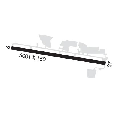
| Rwy | Rwy | |||||||
| 5001x150 | 5001' | 5001x150 | 5001' | |||||
| Runway ID | Single Wheel | Double Wheel | Double Tandem Wheel | Dual Double Wheel |
| 09/27 | 75,000 | 95,000 | 170,000 | N/A |
| H1 | N/A | N/A | N/A | N/A |
| These numbers are Advisory and are not limits. The Airport Manager should have more accurate Weight Limits | ||||
 Airport Diagram might not be current. | |
| Facility Name: | RAMONA |
| City Name: | RAMONA |
| County: | SAN DIEGO |
| State abbrev: | CA |
| State Name: | CALIFORNIA |
| Ownership: | PUBLICLY OWNED |
| Use: | OPEN TO THE PUBLIC |
| Owner's Name: | COUNTY OF SAN DIEGO |
| Address: | 1960 JOE CROSSON DRIVE |
| EL CAJON, CA 92020-1235 | |
| Owner's Phone: | 619-956-4800 |
| Manager's Name: | MEADOW CHASE |
| Address: | 2926 MONTECITO ROAD |
| RAMONA, CA 92065 | |
| Phone: | 760-788-3366; ARPT MGR: CAN ALSO BE REACHED AT FALLBROOK COMMUNITY AIRPARK 760-723-8395. |
| FAA Region: | WESTERN-PACIFIC |
| FAA Field Office: | LAX |
| Date | Sunrise | Sunset |
|---|---|---|
| 04/18/24 Thursday | 6:13 | 19:21 |
| 04/19/24 Friday | 6:12 | 19:22 |
| 04/20/24 Saturday | 6:11 | 19:22 |
| 04/21/24 Sunday | 6:10 | 19:23 |
| 04/22/24 Monday | 6:09 | 19:24 |
| 04/23/24 Tuesday | 6:08 | 19:25 |
| 04/24/24 Wednesday | 6:06 | 19:25 |
| 04/25/24 Thursday | 6:05 | 19:26 |
| 04/26/24 Friday | 6:04 | 19:27 |
| 04/27/24 Saturday | 6:03 | 19:28 |
| 04/28/24 Sunday | 6:02 | 19:28 |
| 04/29/24 Monday | 6:01 | 19:29 |
| 04/30/24 Tuesday | 6:00 | 19:30 |
| 05/01/24 Wednesday | 5:59 | 19:31 |
| Airport Attendance Schedule | 7 Days A Week 0800-2000 |
| Airport Status | OPERATIONAL (This Status can change at any time - please check NOTAMS) |
| Airport Lighting Schedule | ACTVT REIL RWY 27; MIRL RWY 09/27; TWY LGTS - CTAF. PAPI RWY 09 & 27 OPER 24 HRS. |
| Airport Storage Available | Tie Downs |
| Extra Services Available | Flight Instruction, Aircraft Rental, Aircraft Sales |
| Wind Indicator | YES - (lighted) |
| Control Tower | YES |
| CTAF Frequency | 119.875 |
| Unicom Frequency | 122.950 |
| Rotating Beacon Color | WG |
| Segmented Circle | YES |
| Landing Fee | NO |
| Airport Inspected | STATE - performed by STATE AERONAUTICAL PERSONNEL |
| Inspection Date | 09/14/2021 |
| Type of Fuel Available | Grade 100LL, JET A (freeze point -40C) |
| Airframe Repair Service | MAJOR |
| Power Plant Repair Service | MAJOR |
| Latitude | N3302.4 |
| Longitude | W11654.9 (ESTIMATED) |
| Arpt Elevation | 1394ft (SURVEYED) |
| Magnetic Variation | 12E |
| 2 miles W | of RAMONA |
| Traffic Pattern Altitude | 1000 FT SNGL ENG, 1500 FT MULT ENG. |
| Sectional Chart | LOS ANGELES |
| Operations (Reported) | Yearly | Avg. Daily |
|---|---|---|
| General Aviation Transient | 50018 | 137 |
| General Aviation Local | 94236 | 258 |
| Air Taxi | 0 | 0 |
| Commerical | 0 | 0 |
| Commuter | 0 | 0 |
| Military | 725 | 2 |
| Aircraft based on Field | |
|---|---|
| General Aviation Singles | 121 |
| General Aviation Multi | 10 |
| Jet Aircraft | 1 |
| General Aviation Helicopters | 3 |
| Military Aircraft | 0 |
| Gliders | 0 |
| Ultralights | 2 |
| FSS on field | NO |
| FSS tie-in | SAN DIEGO |
| FSS Phone | 1-800-WX-BRIEF |
| Who issues Notams | RNM |
| Notam D service at airport | YES |
| ARTCC Name | LOS ANGELES |
| Airport Certification | |
| Aircraft Rescue & Firefighting Index | None |
| Airport of Entry | No |
| Custom Landing Rights | No |
| Joint Civil/Military | No |
| Military Landing rights | YES |
| NATIONAL PLAN OF INTEGRATED AIRPORT SYSTEMS (NPIAS) |
| GRANT AGREEMENTS UNDER FAAP/ADAP/AIP |
| SURPLUS PROPERTY AGREEMENT UNDER PUBLIC LAW 289 |
| ASSURANCES PURSUANT TO TITLE VI, CIVIL RIGHTS ACT OF 1964 |
| THIS AIRPORT HAS BEEN SURVEYED BY THE NATIONAL GEODETIC SURVEY. |
| HELIPAD PRKG N OF RWY NOT OPEN TO PUB. |
| WHEN TWR CLSD ACFT MUST SELF-ANNOUNCE ON CTAF PRIOR TO LDG OR TKOF. |
| PPR FOR ALL MIL ACFT CTC AMGR. |
| COPTER SKID LNDGS ON RWY AND TWY PROHIBITED. |
| HEL OPS TO HELIPAD S OF RWY RSTRD TO 6000 LBS OR LESS. |
| REPETITIVE COPTER TRG CONDUCTED ON HELIPAD S OF RWY AND TWY A W OF TWR. |
| HELIPAD S OF RWY UNLGTD. |
| HELIPAD S OF RWY DAYTIME VFR USE ONLY. |
| FOR CD WHEN ATCT CLSD CTC SOCAL APCH AT 800-448-3724. |
| WEST TSNT RAMP ADJ TO ATCT RSTRD TO ACFT LESS THAN 12500 LBS. |
| VOLUNTARY JET CURFEW 2200-0700. NOISE SENSITIVE AREA NE-SE. NOISE ABATEMENT: TKOF CLIMB ON RWY HDG UNTIL 1900 FT MSL. |
| FIRE FIGHTING ACFT ON AND IN THE VICINITY OF ARPT. |
| AIR TANKERS IN VCNTY YEAR-ROUND FRQLY FLY NONSTD PAT ENTRIES. |
| RWY 27 CALM WIND RWY. |
| FOR FIRE FIGHTING ACTIVITY CALL AMGR. |
| BE ALERT FOR BIRDS YEAR ROUND, VARIOUS SIZE AND SPECIES. OCNL COYOTE ON OR IN THE VICINITY OF RWY AND TWY. |
Airport Communications & Frequencies:
| ||||||||||||||||||||||||||||||||||
| Runway: 09 | Runway: 27 | ||
| Mag heading: | 87° | Mag heading: | 267° |
| Rwy Slope: | .17% Up | Rwy Slope: | -.17% Down |
| Approach: | Approach: | ||
| Pattern: | Left Traffic | Pattern: | Left Traffic |
| Markings: | NONPRECISION INSTRUMENT | Markings: | NONPRECISION INSTRUMENT |
| Marking Condition: | GOOD | Marking Condition: | GOOD |
| Arresting Dev: | Arresting Dev: | ||
| Lat & Long: | N3302.4 W11655.4 | Lat. & Long.: | N3302.3 W11654.4 |
| Elev: | 1385.8 ft. MSL | Elev: | 1394.5 ft. MSL |
| TCH: | 51 ft. AGL | TCH: | 32 ft. AGL |
| Visual Glide Path: | 3.50 degrees | Visual Glide Path: | 3.50 degrees |
| Displaced Threshold: | No | Displaced Threshold: | No |
| Touchdown Zone: | YES | Touchdown Zone: | YES |
| Touchdown Elev.: | 1388.6 feet | Touchdown Elev.: | 1394.6 feet |
| Visual Glide Slope: | 2-Light PAPI on LEFT side of Runway; UNUSBL BYD 3.0 NM DUE TO TRRN. | Visual Glide Slope: | 2-Light PAPI on LEFT side of Runway |
| RVR Equipment: | RVR Equipment: | ||
| RVV Equipment: | NO | RVV Equipment: | NO |
| Approach Lights: | Approach Lights: | ||
| REIL: | NO | REIL: | YES |
| Centerline Lights: | NO | Centerline Lights: | NO |
| Touchdown lights: | NO | Touchdown lights: | NO |
| Runway Category: | Runway with a Non-precision Approach having visibility minimums greater than 3/4 mile | Runway Category: | Runway with a Visual Approach |
| Declared Distances: | Declared Distances: |


