Click here for more info on on SMS!

KRNH

NEW RICHMOND RGNL
NEW RICHMOND
WI
Time Zone: Central
Lat: N 4508.9
Long: W 09232.4
Elev: 998
Var: -02
Longest Runway: 5507
AWOS: 120.0
CTAF: 122.97

FBO & Flight Services info for KRNH

FBOs: Update your Fuel Prices

EAST METRO AVPh: 715-246-5338 Fax: 715-246-9023 Freq: 122.97
Service
Jet
100LL
SAF
MoGas
Fuel Avail: 24/7 SS, 6a-10p full serve w/no call out fee
Full5.996.04    Last Update: 04/22/2024 09:46

Self  5.54    
 Address: 625 WEST HANGAR ROAD, HANGAR 11-12,   NEW RICHMOND, WI 54017
AWOSPh: 715-246-3202
-
Freq: 120.0  
If you are an FBO, call 1-203-262-1700 to update your info or email: FltPlan.Advertising@garmin.com
Advertise your FBO on FltPlan.com

Runway & Approach Info for KRNH
Rwy
Length
Land Dist**
Approach*
  Rwy
Length
Land Dist**
Approach*
04
2050x75  2050'          
 
  
22
  2050x75  2050'          
 
14
5507x75  5507'          
 
  
32
  5507x75  5507'          
 
 * only ILS, LOC, LDA, and SDF approaches to a specific runway are shown
** For any Declared Landing Distance Available, please see A/FD or Approach plates
Runway Weight Capability (lbs.) Help
Runway IDSingle WheelDouble WheelDouble Tandem WheelDual Double Wheel
04/22N/AN/AN/AN/A
14/3230,00060,000N/AN/A
These numbers are Advisory and are not limits.   The Airport Manager should have more accurate Weight Limits
Approach Charts
Approaches    
Current Weather/Notams
Customs Information Send updates to Support@FltPlan.com
Customs Not Available
Database effective 05/16/2024
Airport Diagram of KRNH
Airport Diagram might not be current.

Facility Name: NEW RICHMOND RGNL
City Name: NEW RICHMOND
County: ST CROIX
State abbrev: WI
State Name: WISCONSIN
   
Ownership: PUBLICLY OWNED
Use: OPEN TO THE PUBLIC
Owner's Name: CITY OF NEW RICHMOND
Address: 156 E FIRST ST
 NEW RICHMOND, WI 54017
Owner's Phone: 715-246-4268
  
Manager's Name: MIKE DEMULLING
Address: 156 E FIRST STREET; EMAIL ADDRESS: MIKE@NRAIRPORT.COM (ALL LOWER CASE)
 NEW RICHMOND, WI 54017
Phone: 715-246-7735
   
FAA Region: GREAT LAKES
FAA Field Office: CHI


Sunrise / Sunset times for NEW RICHMOND RGNL

DateSunriseSunset
04/23/24 Tuesday6:1020:07
04/24/24 Wednesday6:0920:08
04/25/24 Thursday6:0720:10
04/26/24 Friday6:0620:11
04/27/24 Saturday6:0420:12
04/28/24 Sunday6:0220:13
04/29/24 Monday6:0120:15
04/30/24 Tuesday5:5920:16
05/01/24 Wednesday5:5820:17
05/02/24 Thursday5:5620:18
05/03/24 Friday5:5520:20
05/04/24 Saturday5:5420:21
05/05/24 Sunday5:5220:22
05/06/24 Monday5:5120:23

Airport Facilities

Airport Attendance ScheduleCONTINUOUS
Airport Status OPERATIONAL (This Status can change at any time - please check NOTAMS)
Airport Lighting ScheduleMIRL RWY 14/32 PRESET ON LOW INTST; TO INCR INTST & ACTVT REIL RWY 14 & 32; PAPI 14 & 32 - CTAF.
Airport Storage AvailableTie Downs, Hanger
Extra Services AvailableCharter, Flight Instruction, Aircraft Rental, Aircraft Sales
Wind IndicatorYES - (lighted)
Control TowerNO
CTAF Frequency122.975
Unicom Frequency122.975
Rotating Beacon ColorWG
Segmented CircleYES
Landing FeeNO

Airport Inspection Data

Airport InspectedSTATE - performed by STATE AERONAUTICAL PERSONNEL
Inspection Date07/30/2021

Airport Services

Type of Fuel AvailableGrade 100LL, JET A (freeze point -40C)
Airframe Repair ServiceMAJOR
Power Plant Repair ServiceMAJOR

Geographic Data

LatitudeN4508.9
LongitudeW09232.4 (ESTIMATED)
Arpt Elevation997ft (SURVEYED)
Magnetic Variation02E
2 miles Nof NEW RICHMOND
Traffic Pattern Altitude
Sectional ChartGREEN BAY

Aircraft Data

Operations (Reported)YearlyAvg. Daily
General Aviation Transient 2000055
General Aviation Local 2200060
Air Taxi 20005
Commerical 00
Commuter 00
Military 5001
Aircraft based on Field
General Aviation Singles 195
General Aviation Multi 24
Jet Aircraft 7
General Aviation Helicopters 4
Military Aircraft 6
Gliders 1
Ultralights 5

FAA Services

FSS on field NO
FSS tie-in GREEN BAY
FSS Phone 1-800-WX-BRIEF
Who issues Notams RNH
Notam D service at airport YES
ARTCC Name MINNEAPOLIS

Federal Status

Airport Certification
Aircraft Rescue & Firefighting IndexNone
Airport of EntryNo
Custom Landing RightsNo
Joint Civil/MilitaryNo
Military Landing rightsYES

Federal Agreements

NATIONAL PLAN OF INTEGRATED AIRPORT SYSTEMS (NPIAS)
GRANT AGREEMENTS UNDER FAAP/ADAP/AIP
ASSURANCES PURSUANT TO TITLE VI, CIVIL RIGHTS ACT OF 1964

Remarks

GCO AVBL ON FREQ 121.725 THRU MINNEAPOLIS APCH CTL.
AUTOMOBILE AND PEDESTRIAN ACCESS ONTO ARPT PROPERTY RESTRICTED BY SECURITY FENCING AND GATES FM 2200-0600. CTC AMGR 715-246-7735 FOR ACCESS INSTRUCTIONS.
24-HR SELF SVC FUEL AVBL FOR CREDIT CARD USERS OR CALL 715-246-5338.
FOR CD CTC MINNEAPOLIS APCH AT 612-726-9086.
DEER & BIRDS ON & INVOF ARPT.
AEROBATIC PRACTICE AREA 4 NM NE OF ARPT.
ULTRALIGHT ACTIVITY ON & INVOF ARPT.
SEAPLANE TRAFFIC ADJACENT TO SOUTH SIDE OF ARPT.
TURBO-JET TOUCH & GO NOT AUTHORIZED.
BRIGHT LGTS FM BALL FIELDS 1/2 MI SOUTH DURG EVENINGS MAY THRU SEP.
RWY 04/2 2 MARKED WITH WHITE CONES. OPEN TO SKI EQUIPPED ACFT WINTER MONTHS.
Airport Communications & Frequencies:
CTAF Frequency:
122.975
Unicom Frequency:
122.975
MINNEAPOLIS Primary Approach Frequencies:  
121.2
335.65
MINNEAPOLIS Primary Departure Frequencies:  
121.2
335.65
Runway Identifications
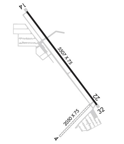
Runway Identification: 04/22
Length: 2050 ft
Width: 75 ft
Surface: GRASS-FAIR CONDITION
Edge lights:

Treatment: NONE

 Runway: 04   Runway: 22
Mag heading: 42°Mag heading: 222°
Rwy Slope: .16% UpRwy Slope: -.16% Down
Approach: Approach:
Pattern: Left TrafficPattern: Left Traffic
Markings: NONEMarkings: NONE
Marking Condition: Marking Condition:
Arresting Dev: Arresting Dev:
Lat & Long: N4508.4  W09232.4Lat. & Long.: N4508.6  W09232.1
Elev: 989.9 ft. MSLElev: 993.1 ft. MSL
TCH: TCH:
Visual Glide Path: Visual Glide Path:
Displaced Threshold: NoDisplaced Threshold: No
Touchdown Zone: YESTouchdown Zone: YES
Touchdown Elev.: 993.1 feetTouchdown Elev.: 993.1 feet
Visual Glide Slope: Visual Glide Slope:
RVR Equipment: RVR Equipment:
RVV Equipment: NORVV Equipment: NO
Approach Lights: Approach Lights:
REIL: NOREIL: NO
Centerline Lights: NOCenterline Lights: NO
Touchdown lights: NOTouchdown lights: NO
Runway Category: Runway with a Visual ApproachRunway Category: Runway with a Visual Approach
Declared Distances: Declared Distances:
Runway Identification: 14/32
Length: 5507 ft
Width: 75 ft
Surface: ASPHALT-GOOD CONDITION
Edge lights: Medium Intensity

Treatment: NONE

 Runway: 14   Runway: 32
Mag heading: 141°Mag heading: 321°
Rwy Slope: -.02% DownRwy Slope: .02% Up
Approach: Approach:
Pattern: Left TrafficPattern: Left Traffic
Markings: NONPRECISION INSTRUMENTMarkings: NONPRECISION INSTRUMENT
Marking Condition: GOODMarking Condition: GOOD
Arresting Dev: Arresting Dev:
Lat & Long: N4509.4  W09232.8Lat. & Long.: N4508.6  W09232.0
Elev: 997.5 ft. MSLElev: 996.3 ft. MSL
TCH: 40 ft. AGLTCH: 20 ft. AGL
Visual Glide Path: 3.00 degreesVisual Glide Path: 3.00 degrees
Displaced Threshold: NoDisplaced Threshold: No
Touchdown Zone: YESTouchdown Zone: YES
Touchdown Elev.: 997.9 feetTouchdown Elev.: 996.4 feet
Visual Glide Slope: 4-Light PAPI on LEFT side of RunwayVisual Glide Slope: 4-Light PAPI on LEFT side of Runway; PAPI RWY 32 UNUSBL BYD 4 DEG R OF COURSE.
RVR Equipment: RVR Equipment:
RVV Equipment: NORVV Equipment: NO
Approach Lights: Approach Lights:
REIL: YESREIL: YES
Centerline Lights: NOCenterline Lights: NO
Touchdown lights: NOTouchdown lights: NO
Runway Category: Runway with a Non-precision Approach having visibility minimums greater than 3/4 mileRunway Category: Runway with a Non-precision Approach having visibility minimums greater than 3/4 mile
Declared Distances: Declared Distances:
Obstructions: TREEObstructions:
Marked: NOT Marked/LightedMarked:
Clearance slope: 20:1Clearance slope: 34:1
Obstruction height: 65 feet AGLObstruction height:
Dist. from runway: 1500 feetDist. from runway:
Centerline offset: 230 left of centerlineCenterline offset:
Comments: Comments:
C:15/P: