Click here for more info on on SMS!

KRNC

WARREN COUNTY MEMORIAL
MC MINNVILLE
TN
Time Zone: Central
Lat: N 3541.9
Long: W 08550.6
Elev: 1032
Var: +02
Longest Runway: 5000
Clr Del: 121.72 GCO
AWOS: 135.52
CTAF: 123.05

FBO & Flight Services info for KRNC

FBOs: Update your Fuel Prices

WARREN COUNTY APPh: 931-668-7050 Fax: 931-668-2651 Freq: 122.8
Service
Jet
100LL
SAF
MoGas
Fuel Avail: Fuel Available 24/7 Closed Thanksgiving and Christmas Days
Full4.69      Last Update: 04/18/2024 09:00
PRICES GUARANTEED by FBO.
Self4.695.23    
 Address: 4187 NASHVILLE HWY   MCMINNVILLE, TN 37110
AWOSPh: 931-668-7056
-
Freq: 135.52  
If you are an FBO, call 1-203-262-1700 to update your info or email: FltPlan.Advertising@garmin.com
Advertise your FBO on FltPlan.com

Runway & Approach Info for KRNC
Rwy
Length
Land Dist**
Approach*
  Rwy
Length
Land Dist**
Approach*
05
5000x100  5000'          
 
  
23
  5000x100  5000'          
 
 * only ILS, LOC, LDA, and SDF approaches to a specific runway are shown
** For any Declared Landing Distance Available, please see A/FD or Approach plates
Runway Weight Capability (lbs.) Help
Runway IDSingle WheelDouble WheelDouble Tandem WheelDual Double Wheel
05/2329,00048,000N/AN/A
These numbers are Advisory and are not limits.   The Airport Manager should have more accurate Weight Limits
Approach Charts
Approaches    
Current Weather/Notams
Customs Information Send updates to Support@FltPlan.com
Customs Not Available
Database effective 04/18/2024
Airport Diagram of KRNC
Airport Diagram might not be current.

Facility Name: WARREN COUNTY MEML
City Name: MC MINNVILLE
County: WARREN
State abbrev: TN
State Name: TENNESSEE
   
Ownership: PUBLICLY OWNED
Use: OPEN TO THE PUBLIC
Owner's Name: WARREN COUNTY
Address: WARREN COUNTY COURTHOUSE, 201 LOCUST STREET
 MCMINNVILLE, TN 37110
Owner's Phone: 931-473-2505
  
Manager's Name: JIM DYER
Address: 48 WEST AIRPORT ROAD
 MC MINNVILLE, TN 37110
Phone: 931-668-7050
   
FAA Region: SOUTHERN
FAA Field Office: MEM


Sunrise / Sunset times for WARREN COUNTY MEML

DateSunriseSunset
04/19/24 Friday6:0519:21
04/20/24 Saturday6:0319:22
04/21/24 Sunday6:0219:22
04/22/24 Monday6:0119:23
04/23/24 Tuesday6:0019:24
04/24/24 Wednesday5:5819:25
04/25/24 Thursday5:5719:26
04/26/24 Friday5:5619:27
04/27/24 Saturday5:5519:27
04/28/24 Sunday5:5419:28
04/29/24 Monday5:5319:29
04/30/24 Tuesday5:5219:30
05/01/24 Wednesday5:5119:31
05/02/24 Thursday5:4919:32

Airport Facilities

Airport Attendance Schedule7 Days A Week 0800-1700; AFT HR SVC - 931-607-2629; CLSD THANKSGIVING & CHRISTMAS.
Airport Status OPERATIONAL (This Status can change at any time - please check NOTAMS)
Airport Lighting ScheduleACTVT REIL RWY 05 & 23; PAPI RWY 05 & 23; MIRL RWY 05/23 - CTAF. MIRL RWY 05/23 PRESET LOW INTST; INCR INTST - CTAF.
Airport Storage AvailableTie Downs, Hanger
Extra Services AvailableNONE
Wind IndicatorYES - (lighted)
Control TowerNO
CTAF Frequency123.050
Unicom Frequency123.050
Rotating Beacon ColorWG
Segmented CircleYES
Landing FeeNO

Airport Inspection Data

Airport InspectedSTATE - performed by STATE AERONAUTICAL PERSONNEL
Inspection Date07/03/2023

Airport Services

Type of Fuel AvailableGrade 100LL, JET A
Airframe Repair ServiceMAJOR
Power Plant Repair ServiceMAJOR

Geographic Data

LatitudeN3541.9
LongitudeW08550.6 (ESTIMATED)
Arpt Elevation1031ft (SURVEYED)
Magnetic Variation02W
3 miles Wof MC MINNVILLE
Traffic Pattern Altitude
Sectional ChartATLANTA

Aircraft Data

Operations (Reported)YearlyAvg. Daily
General Aviation Transient 750021
General Aviation Local 1700047
Air Taxi 00
Commerical 00
Commuter 00
Military 300
Aircraft based on Field
General Aviation Singles 36
General Aviation Multi 6
Jet Aircraft 1
General Aviation Helicopters 0
Military Aircraft 0
Gliders 0
Ultralights 0

FAA Services

FSS on field NO
FSS tie-in NASHVILLE
FSS Phone 1-800-WX-BRIEF
Who issues Notams BNA
Notam D service at airport YES
ARTCC Name MEMPHIS

Federal Status

Airport Certification
Aircraft Rescue & Firefighting IndexNone
Airport of EntryNo
Custom Landing RightsNo
Joint Civil/MilitaryNo
Military Landing rightsYES

Federal Agreements

NATIONAL PLAN OF INTEGRATED AIRPORT SYSTEMS (NPIAS)
GRANT AGREEMENTS UNDER FAAP/ADAP/AIP
ASSURANCES PURSUANT TO TITLE VI, CIVIL RIGHTS ACT OF 1964

Remarks

FOR CD CTC MEMPHIS ARTCC AT 901-368-8453/8449.
Airport Communications & Frequencies:
CTAF Frequency:
123.050
Unicom Frequency:
123.050
Remarks
  • APCH/DEP SVC PRVDD BY MEMPHIS ARTCC ON FREQS 128.15/323.125 (SHELBYVILLE RCAG).
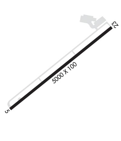
  • Runway Identifications
    Runway Identification: 05/23
    Length: 5000 ft
    Width: 100 ft
    Surface: ASPHALT-GOOD CONDITION
    Edge lights: Medium Intensity

    Treatment: NONE
    Weight: PCN 39 /F/C/X/T

     Runway: 05   Runway: 23
    Mag heading: 53°Mag heading: 233°
    Rwy Slope: -.11% DownRwy Slope: .11% Up
    Approach: Approach:
    Pattern: Left TrafficPattern: Left Traffic
    Markings: NONPRECISION INSTRUMENTMarkings: NONPRECISION INSTRUMENT
    Marking Condition: GOODMarking Condition: GOOD
    Arresting Dev: Arresting Dev:
    Lat & Long: N3541.7  W08551.0Lat. & Long.: N3542.2  W08550.2
    Elev: 1031.9 ft. MSLElev: 1026.4 ft. MSL
    TCH: 35 ft. AGLTCH: 18 ft. AGL
    Visual Glide Path: 3.50 degreesVisual Glide Path: 3.00 degrees
    Displaced Threshold: NoDisplaced Threshold: No
    Touchdown Zone: YESTouchdown Zone: YES
    Touchdown Elev.: 1031.9 feetTouchdown Elev.: 1026.4 feet
    Visual Glide Slope: 4-Light PAPI on LEFT side of Runway; PAPI UNUSBL BYD 7 DEGS LEFT OF CNTRLN.Visual Glide Slope: 4-Light PAPI on LEFT side of Runway
    RVR Equipment: RVR Equipment:
    RVV Equipment: NORVV Equipment: NO
    Approach Lights: Approach Lights:
    REIL: YESREIL: YES
    Centerline Lights: NOCenterline Lights: NO
    Touchdown lights: NOTouchdown lights: NO
    Runway Category: Runway with a Non-precision Approach having visibility minimums greater than 3/4 mileRunway Category: Runway with a Non-precision Approach having visibility minimums greater than 3/4 mile
    Declared Distances: Declared Distances:
    Obstructions: TREESObstructions:
    Marked: NOT Marked/LightedMarked:
    Clearance slope: 14:1Clearance slope: 34:1; OBSTN CLNC SLOPE 40:1 AT DTHR.
    Obstruction height: 107 feet AGLObstruction height:
    Dist. from runway: 1797 feetDist. from runway:
    Centerline offset: 349 right of centerlineCenterline offset:
    Comments: Comments:
    C:5/P: