Current Weather/Notams (Metars, TAFs, Notams, NWS Forecast, PIREPS, and nearby weather)
Customs Information Send updates to Support@FltPlan.com
Customs Not Available
Database effective 04/18/2024
Airport Diagram might not be current.
|
| Facility Name: | RICHARD B RUSSELL RGNL - J H TOWERS FLD |
| City Name: | ROME |
| County: | FLOYD |
| State abbrev: | GA |
| State Name: | GEORGIA |
| | |
| Ownership: | PUBLICLY OWNED |
| Use: | OPEN TO THE PUBLIC |
| Owner's Name: | FLOYD COUNTY |
| Address: | PO BOX 946 |
| | ROME, GA 30161 |
| Owner's Phone: | 706-295-7835 |
| | |
| Manager's Name: | JOHN CARROLL |
| Address: | 304 RUSSELL FIELD RD NE |
| | ROME, GA 30161 |
| Phone: | 706-295-7835 |
| | |
| FAA Region: | SOUTHERN |
| FAA Field Office: | ATL |
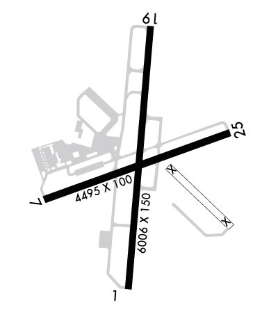
Runway Identifications
Runway Identification: 01/19Length: 6006 ft
Width: 150 ft
Surface: ASPHALT-GOOD CONDITION
Edge lights: High IntensityTreatment: GROOVED
| | Runway: 01 | | Runway: 19 |
| Mag heading: | 7° | Mag heading: | 187° |
| Rwy Slope: | -.13% Down | Rwy Slope: | .13% Up |
| Approach: | ILS/DME | Approach: | |
| Pattern: | Left Traffic | Pattern: | Left Traffic |
| Markings: | PRECISION INSTRUMENT | Markings: | PRECISION INSTRUMENT |
| Marking Condition: | FAIR | Marking Condition: | FAIR |
| Arresting Dev: | | Arresting Dev: | |
| Lat & Long: | N3420.6 W08509.6 | Lat. & Long.: | N3421.6 W08509.5 |
| Elev: | 632.3 ft. MSL | Elev: | 624.4 ft. MSL |
| TCH: | 46 ft. AGL | TCH: | 45 ft. AGL |
| Visual Glide Path: | 3.00 degrees | Visual Glide Path: | 3.00 degrees |
| Displaced Threshold: | No | Displaced Threshold: | No |
| Touchdown Zone: | YES | Touchdown Zone: | YES |
| Touchdown Elev.: | 635.8 feet | Touchdown Elev.: | 634.8 feet |
| Visual Glide Slope: | 4-Light PAPI on LEFT side of Runway | Visual Glide Slope: | 4-Light PAPI on LEFT side of Runway |
| RVR Equipment: | | RVR Equipment: | |
| RVV Equipment: | NO | RVV Equipment: | NO |
| Approach Lights: | MALSR - 1,400 foot medium intensity approach lighting system with runway alignment indicator lights | Approach Lights: | |
| REIL: | NO | REIL: | NO |
| Centerline Lights: | NO | Centerline Lights: | NO |
| Touchdown lights: | NO | Touchdown lights: | NO |
| Runway Category: | Precision Instrument Runway | Runway Category: | Runway with a Non-precision Approach having visibility minimums greater than 3/4 mile |
| Declared Distances: | | Declared Distances: | |
| Obstructions: | TREES | Obstructions: | TREES |
| Marked: | NOT Marked/Lighted | Marked: | NOT Marked/Lighted |
| Clearance slope: | 25:1 | Clearance slope: | 32:1 |
| Obstruction height: | 106 feet AGL | Obstruction height: | 136 feet AGL |
| Dist. from runway: | 2867 feet | Dist. from runway: | 4562 feet |
| Centerline offset: | 666 right of centerline | Centerline offset: | 340 feet right of centerline |
| Comments: | | Comments: | |
Runway Identification: 07/25Length: 4495 ft
Width: 100 ft
Surface: ASPHALT
Edge lights: Treatment: NONE
| | Runway: 07 | | Runway: 25 |
| Mag heading: | 72° | Mag heading: | 252° |
| Rwy Slope: | -.40% Down | Rwy Slope: | .40% Up |
| Approach: | | Approach: | |
| Pattern: | Left Traffic | Pattern: | Left Traffic |
| Markings: | NONPRECISION INSTRUMENT | Markings: | NONPRECISION INSTRUMENT |
| Marking Condition: | GOOD | Marking Condition: | GOOD |
| Arresting Dev: | | Arresting Dev: | |
| Lat & Long: | N3420.9 W08509.9 | Lat. & Long.: | N3421.2 W08509.1 |
| Elev: | 644.1 ft. MSL | Elev: | 626.0 ft. MSL |
| TCH: | | TCH: | |
| Visual Glide Path: | | Visual Glide Path: | |
| Displaced Threshold: | 115 feet | Displaced Threshold: | No |
| Touchdown Zone: | YES | Touchdown Zone: | YES |
| Touchdown Elev.: | 643.8 feet | Touchdown Elev.: | 638.1 feet |
| Visual Glide Slope: | | Visual Glide Slope: | |
| RVR Equipment: | | RVR Equipment: | |
| RVV Equipment: | NO | RVV Equipment: | NO |
| Approach Lights: | | Approach Lights: | |
| REIL: | NO | REIL: | NO |
| Centerline Lights: | NO | Centerline Lights: | NO |
| Touchdown lights: | NO | Touchdown lights: | NO |
| Runway Category: | Runway with a Non-precision Approach having visibility minimums greater than 3/4 mile | Runway Category: | Runway with a Non-precision Approach having visibility minimums greater than 3/4 mile |
| Declared Distances: | TORA:4495' TODA:4495' ASDA:4495' LDA:4380' | Declared Distances: | TORA:4495' TODA:4495' ASDA:4495' LDA:4495' |
| Obstructions: | ROAD | Obstructions: | TREE |
| Marked: | NOT Marked/Lighted | Marked: | NOT Marked/Lighted |
| Clearance slope: | 4:1; RWY 07 - APCH RATIO 13:1 AT DSPLCD THLD; 67 FT TREES 1071 FT FM DSPLCD THLD 350 FT L. | Clearance slope: | 15:1 |
| Obstruction height: | 15 feet AGL | Obstruction height: | 51 feet AGL |
| Dist. from runway: | 260 feet | Dist. from runway: | 975 feet |
| Centerline offset: | 300 right of centerline | Centerline offset: | 361 feet left of centerline |
| Comments: | | Comments: | |

