Click here for more info on on SMS!

KRKD

KNOX COUNTY RGNL
ROCKLAND
ME
Time Zone: Eastern
Lat: N 4403.6
Long: W 06906.0
Elev: 55
Var: +18
Longest Runway: 5412
Clr Del: 123.8
AWOS: 119.02
CTAF: 123.05

FBO & Flight Services info for KRKD

FBOs: Update your Fuel Prices
A full service FBO offering 24 Hour on request fueling-Jet A & 100LL; Maintenance; Heated hangar space; Large passenger lounge; Pilots lounge; Snooze rooms; Courtesy car; Catering; Lav service; De-icing service; Complimentary coffee, ice, & internet access; On-site car rental; Free Lobsters with minimum fuel purchase (Advance notice requested.)
Ph: 207-594-2171 Fax: 207-594-2172 Freq: 129.72WebsiteE-Mail
                                   
Service
Jet
100LL
SAF
MoGas
Fuel Avail: PRIST+ $0.07/gal.
Full6.066.34    Last Update: 04/08/2024 09:57

Self        
Misc. Info: Address: 19 TERMINAL LANE,   OWLS HEAD, ME 04854

AWOSPh: 207-594-7946
-
Freq: 119.02  
If you are an FBO, call 1-203-262-1700 to update your info or email: FltPlan.Advertising@garmin.com
Advertise your FBO on FltPlan.com

Runway & Approach Info for KRKD
Rwy
Length
Land Dist**
Approach*
  Rwy
Length
Land Dist**
Approach*
03
4000x100  4000'          
 
  
21
  4000x100  4000'          
 
13
5412x100  5012'          
ILS/DME
 111.70 - 128°  
  
31
  5412x100  5412'          
 
 * only ILS, LOC, LDA, and SDF approaches to a specific runway are shown
** For any Declared Landing Distance Available, please see A/FD or Approach plates
Runway Weight Capability (lbs.) Help
Runway IDSingle WheelDouble WheelDouble Tandem WheelDual Double Wheel
03/2165,00080,000N/AN/A
13/3165,00080,000N/AN/A
These numbers are Advisory and are not limits.   The Airport Manager should have more accurate Weight Limits
Approach Charts
Approaches    
Current Weather/Notams
Customs Information Send updates to Support@FltPlan.com
Customs Not Available
Database effective 04/18/2024
Airport Diagram of KRKD
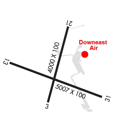
Airport Diagram might not be current.

Facility Name: KNOX COUNTY RGNL
City Name: ROCKLAND
County: KNOX
State abbrev: ME
State Name: MAINE
   
Ownership: PUBLICLY OWNED
Use: OPEN TO THE PUBLIC
Owner's Name: KNOX COUNTY
Address: 62 UNION ST
 ROCKLAND, ME 04841
Owner's Phone: 207-594-0420
  
Manager's Name: JEREMY SHAW
Address: 5 AIRPORT RD
 OWLS HEAD, ME 04854
Phone: 207-594-4131
   
FAA Region: NEW ENGLAND
FAA Field Office: NONE


Sunrise / Sunset times for KNOX COUNTY RGNL

DateSunriseSunset
04/18/24 Thursday5:4719:25
04/19/24 Friday5:4519:26
04/20/24 Saturday5:4419:27
04/21/24 Sunday5:4219:29
04/22/24 Monday5:4019:30
04/23/24 Tuesday5:3919:31
04/24/24 Wednesday5:3719:32
04/25/24 Thursday5:3619:33
04/26/24 Friday5:3419:35
04/27/24 Saturday5:3319:36
04/28/24 Sunday5:3119:37
04/29/24 Monday5:3019:38
04/30/24 Tuesday5:2819:39
05/01/24 Wednesday5:2719:41

Airport Facilities

Airport Attendance ScheduleMON-FRI 0600-1700; ARPT MAY BE UNATNDD FM 2200-0600.
Airport Status OPERATIONAL (This Status can change at any time - please check NOTAMS)
Airport Lighting ScheduleACTVT MALSR RWY 13; REIL RWY 03 & 31; PAPI RWY 03, 13 & 31; HIRL RWY 13/31; MIRL RWY 03/21 - CTAF.
Airport Storage AvailableTie Downs, Hanger
Extra Services AvailableAir Freight, Charter, Flight Instruction, Aircraft Rental
Wind IndicatorYES - (lighted)
Control TowerNO
CTAF Frequency123.050
Unicom Frequency123.050
Rotating Beacon ColorWG
Segmented CircleYES
Landing FeeNO

Airport Inspection Data

Airport InspectedSTATE - performed by PRIVATE CONTRACT PERSONNEL
Inspection Date08/17/2023

Airport Services

Type of Fuel AvailableGrade 100LL, JET A (freeze point -40C)
Airframe Repair ServiceMAJOR
Power Plant Repair ServiceMAJOR

Geographic Data

LatitudeN4403.6
LongitudeW06906.0 (ESTIMATED)
Arpt Elevation55ft (SURVEYED)
Magnetic Variation18W
3 miles Sof ROCKLAND
Traffic Pattern Altitude
Sectional ChartMONTREAL

Aircraft Data

Operations (Reported)YearlyAvg. Daily
General Aviation Transient 601116
General Aviation Local 414011
Air Taxi 479113
Commerical 25967
Commuter 00
Military 460
Aircraft based on Field
General Aviation Singles 54
General Aviation Multi 1
Jet Aircraft 2
General Aviation Helicopters 0
Military Aircraft 0
Gliders 1
Ultralights 0

FAA Services

FSS on field NO
FSS tie-in BANGOR
FSS Phone 1-800-WX-BRIEF
Who issues Notams RKD
Notam D service at airport YES
ARTCC Name BOSTON

Federal Status

Airport Certification
Aircraft Rescue & Firefighting IndexNone
Airport of EntryNo
Custom Landing RightsNo
Joint Civil/MilitaryNo
Military Landing rightsYES

Federal Agreements

NATIONAL PLAN OF INTEGRATED AIRPORT SYSTEMS (NPIAS)
GRANT AGREEMENTS UNDER FAAP/ADAP/AIP
SURPLUS PROPERTY AGREEMENT UNDER PUBLIC LAW 289
SURPLUS PROPERTY AGREEMENT UNDER REGULATION 16-WAA
ASSURANCES PURSUANT TO TITLE VI, CIVIL RIGHTS ACT OF 1964
AGREEMENT UNDER DLAND OR DCLA HAS EXPIRED.

Remarks

DEER & SEAGULLS ON & INVOF ARPT.
VOLUNTARY NGT CUFREW IN EFCT 2230-0600.
NOISE ABATEMENT PROCS IN EFCT, CALL 207-596-0617 OR VISIT WEBSITE FOR SPECIFIC INSTRUCTIONS.
FOR CD WHEN APCH CLSD CTC BOSTON ARTCC AT 603-879-6859.
Airport Communications & Frequencies:
Clearance Delivery Frequencies:
123.8
CTAF Frequency:
123.050
Unicom Frequency:
123.050
Remarks
  • APCH/DEP SVC PRVDD BY BOSTON ARTCC ON FREQS 128.2/263.05 (112-292) (WATERBORO RCAG); FREQS 124.25/290.50 (293-111) (BANGOR RCAG) WHEN PORTLAND APCH CTL CLSD.
  • PORTLAND Primary Approach Frequencies:  
    120.4
    299.2
    PORTLAND Primary Departure Frequencies:  
    120.4
    299.2
    Runway Identifications
    Runway Identification: 03/21
    Length: 4000 ft
    Width: 100 ft
    Surface: ASPHALT-GOOD CONDITION
    Edge lights: Medium Intensity

    Treatment: NONE

     Runway: 03   Runway: 21
    Mag heading: 31°Mag heading: 211°
    Rwy Slope: .12% UpRwy Slope: -.12% Down
    Approach: Approach:
    Pattern: Left TrafficPattern: Left Traffic
    Markings: NONPRECISION INSTRUMENTMarkings: NONPRECISION INSTRUMENT
    Marking Condition: GOODMarking Condition: GOOD
    Arresting Dev: Arresting Dev:
    Lat & Long: N4403.4  W06906.0Lat. & Long.: N4404.0  W06905.8
    Elev: 50.2 ft. MSLElev: 55.1 ft. MSL
    TCH: 34 ft. AGLTCH:
    Visual Glide Path: 3.00 degreesVisual Glide Path:
    Displaced Threshold: NoDisplaced Threshold: No
    Touchdown Zone: YESTouchdown Zone: YES
    Touchdown Elev.: 54.2 feetTouchdown Elev.: 55.1 feet
    Visual Glide Slope: 4-Light PAPI on LEFT side of RunwayVisual Glide Slope:
    RVR Equipment: RVR Equipment:
    RVV Equipment: NORVV Equipment: NO
    Approach Lights: Approach Lights:
    REIL: YESREIL: NO
    Centerline Lights: NOCenterline Lights: NO
    Touchdown lights: NOTouchdown lights: NO
    Runway Category: Runway with a Non-precision Approach having visibility minimums greater than 3/4 mileRunway Category: Runway with a Visual Approach
    Declared Distances: TORA:4000' TODA:4000' ASDA:4000' LDA:4000'Declared Distances: TORA:4000' TODA:4000' ASDA:4000' LDA:4000'
    Obstructions: TREESObstructions: TREES
    Marked: NOT Marked/LightedMarked: NOT Marked/Lighted
    Clearance slope: 6:1Clearance slope: 6:1
    Obstruction height: 26 feet AGLObstruction height: 50 feet AGL
    Dist. from runway: 357 feetDist. from runway: 525 feet
    Centerline offset: 270 right of centerlineCenterline offset: 250 feet left of centerline
    Comments: Comments:
    Runway Identification: 13/31
    Length: 5412 ft
    Width: 100 ft
    Surface: ASPHALT
    Edge lights: High Intensity

    Treatment: GROOVED

     Runway: 13   Runway: 31
    Mag heading: 129°Mag heading: 309°
    Rwy Slope: .17% UpRwy Slope: -.17% Down
    Approach: ILS/DMEApproach:
    Pattern: Left TrafficPattern: Left Traffic
    Markings: PRECISION INSTRUMENTMarkings: PRECISION INSTRUMENT
    Marking Condition: GOODMarking Condition: GOOD
    Arresting Dev: Arresting Dev:
    Lat & Long: N4403.7  W06906.6Lat. & Long.: N4403.4  W06905.4
    Elev: 45.6 ft. MSLElev: 54.7 ft. MSL
    TCH: 51 ft. AGLTCH: 50 ft. AGL
    Visual Glide Path: 3.00 degreesVisual Glide Path: 3.00 degrees
    Displaced Threshold: 400 feetDisplaced Threshold: No
    Touchdown Zone: YESTouchdown Zone: YES
    Touchdown Elev.: 53.5 feetTouchdown Elev.: 55.4 feet
    Visual Glide Slope: 4-Light PAPI on RIGHT side of RunwayVisual Glide Slope: 4-Light PAPI on LEFT side of Runway
    RVR Equipment: RVR Equipment:
    RVV Equipment: NORVV Equipment: NO
    Approach Lights: MALSR - 1,400 foot medium intensity approach lighting system with runway alignment indicator lightsApproach Lights:
    REIL: NOREIL: YES
    Centerline Lights: NOCenterline Lights: NO
    Touchdown lights: NOTouchdown lights: NO
    Runway Category: Precision Instrument RunwayRunway Category: Runway with a Non-precision Approach having visibility minimums greater than 3/4 mile
    Declared Distances: TORA:5412' TODA:5412' ASDA:5412' LDA:5012'Declared Distances: TORA:5412' TODA:5412' ASDA:5412' LDA:5412'
    Obstructions: Obstructions: TREES
    Marked: Marked: NOT Marked/Lighted
    Clearance slope: 50:1Clearance slope: 6:1
    Obstruction height: Obstruction height: 40 feet AGL
    Dist. from runway: Dist. from runway: 450 feet
    Centerline offset: Centerline offset: 475 feet right of centerline
    Comments: Comments:
    C:29/P: