
| ||||||||||||||||||||||||||||||||||||||||||||
| ||||||||||||||||||||||||||||||||||||||||||||
| ||||||||||||||||||||||||||||||||||||||||||||
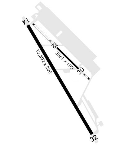
| Rwy | Rwy | |||||||
| 3061x100 | 3061' | 3061x100 | 3061' | |||||
| 13302x200 | 13302' | 13302x200 | 13302' | 110.10 - 315° | ||||
| Runway ID | Single Wheel | Double Wheel | Double Tandem Wheel | Dual Double Wheel |
| 12/30 | N/A | N/A | N/A | N/A |
| 14/32 | N/A | N/A | N/A | N/A |
| These numbers are Advisory and are not limits. The Airport Manager should have more accurate Weight Limits | ||||
 Airport Diagram might not be current. | |
| Facility Name: | MARCH ARB |
| City Name: | RIVERSIDE |
| County: | RIVERSIDE |
| State abbrev: | CA |
| State Name: | CALIFORNIA |
| Ownership: | AIR FORCE OWNED |
| Use: | OPEN TO THE PUBLIC |
| Owner's Name: | UNITED STATES AIR FORCE |
| Address: | 2685 GRAEBER STREET, BLDG 395 |
| MARCH ARB, CA 92518 | |
| Owner's Phone: | 951-655-4053 |
| Manager's Name: | BART W. DARNELL |
| Address: | 2685 GRAEBER STREET, BLDG 395 |
| MARCH ARB, CA 92518 | |
| Phone: | 951-655-4053 |
| FAA Region: | WESTERN-PACIFIC |
| FAA Field Office: | LAX |
| Date | Sunrise | Sunset |
|---|---|---|
| 04/18/24 Thursday | 6:14 | 19:23 |
| 04/19/24 Friday | 6:12 | 19:24 |
| 04/20/24 Saturday | 6:11 | 19:25 |
| 04/21/24 Sunday | 6:10 | 19:26 |
| 04/22/24 Monday | 6:09 | 19:26 |
| 04/23/24 Tuesday | 6:08 | 19:27 |
| 04/24/24 Wednesday | 6:07 | 19:28 |
| 04/25/24 Thursday | 6:06 | 19:29 |
| 04/26/24 Friday | 6:04 | 19:29 |
| 04/27/24 Saturday | 6:03 | 19:30 |
| 04/28/24 Sunday | 6:02 | 19:31 |
| 04/29/24 Monday | 6:01 | 19:32 |
| 04/30/24 Tuesday | 6:00 | 19:33 |
| 05/01/24 Wednesday | 5:59 | 19:33 |
| Airport Attendance Schedule | 7 Days A Week 0700-2300; OPR H24; OPS FM 0700-1500Z++ RQR 452 OG/CC APVL, EXC FOR KRIV BASED ALERT MSN. |
| Airport Status | OPERATIONAL (This Status can change at any time - please check NOTAMS) |
| Airport Lighting Schedule | |
| Airport Storage Available | NONE |
| Extra Services Available | Cargo Handling, Charter |
| Wind Indicator | NONE |
| Control Tower | YES |
| CTAF Frequency | |
| Unicom Frequency | |
| Rotating Beacon Color | WG |
| Segmented Circle | NO |
| Landing Fee | NO |
| Airport Inspected | No Inspection Data Available performed by the OWNER |
| Inspection Date | 09/09/1976 |
| Type of Fuel Available | Grade 100LL, JET A (freeze point -40C)A++; -10FULL SVC AVBL AT FBO; SELF-SERVE UNAVBL. |
| Airframe Repair Service | MAJOR |
| Power Plant Repair Service | MAJOR |
| Latitude | N3352.9 |
| Longitude | W11715.5 (ESTIMATED) |
| Arpt Elevation | 1536ft (SURVEYED) |
| Magnetic Variation | 14E |
| 6 miles SE | of RIVERSIDE |
| Traffic Pattern Altitude | TFC PAT - RECTANGULAR 3000', OVERHEAD 3500'. |
| Sectional Chart | LOS ANGELES |
| Operations (Reported) | Yearly | Avg. Daily |
|---|---|---|
| General Aviation Transient | 0 | 0 |
| General Aviation Local | 0 | 0 |
| Air Taxi | 0 | 0 |
| Commerical | 0 | 0 |
| Commuter | 0 | 0 |
| Military | 0 | 0 |
| Aircraft based on Field | |
|---|---|
| General Aviation Singles | 2 |
| General Aviation Multi | 0 |
| Jet Aircraft | 0 |
| General Aviation Helicopters | 0 |
| Military Aircraft | 0 |
| Gliders | 0 |
| Ultralights | 0 |
| FSS on field | NO |
| FSS tie-in | RIVERSIDE |
| FSS Phone | 1-800-WX-BRIEF |
| Who issues Notams | RIV |
| Notam D service at airport | YES |
| ARTCC Name | LOS ANGELES |
| Airport Certification | |
| Aircraft Rescue & Firefighting Index | None |
| Airport of Entry | YES |
| Custom Landing Rights | No |
| Joint Civil/Military | YES |
| Military Landing rights | No |
| NATIONAL PLAN OF INTEGRATED AIRPORT SYSTEMS (NPIAS) |
| CAUTION: NSTD RWY MRK-LANDING ZONE (LZ) MARK (3500X90 PAINTED ON RWY 32 FOR BASE ASGN C17 ACFT ONLY). |
| TSNT ACFT NO PRACTICE APCH 2100-0700. |
| GEN AVN OPS PMTD DUR FBO BUS HRS. FBO BUS HRS 1400-0600Z++ MON-FRI, OPEN SAT-SUN (IF REQ PRIOR TO CLOSE OF BUS FRI) AND WILL HONOR MEDICAL REQ MADE AT ANY TIME, CALL 951-247-2111. |
| USE EXTREME CAUTION FOR EXTV UAS OPS IN VCNTY. |
| NONSTANDARD TACAN CHECKPOINT SIGNS LCTD AT RWY A AND TWY F. |
| MIL |
| MIL |
| CSTMS/AG/IMG - CTC AFLD MGMT OPS DSN 447-4404/2422, C951-655-4404/2422 AT LEAST 24 HR PN TO ARR RQR. LTD SVC, NO RESIDENT CSTMS AGENT, BUT ON CALL H24, DRIVING FR ONTARIO INTL. NO-NTC ACFT THAT RQR CSTMS EXP MIN 2 HR DELAY. CSTMS RQR FOLLOWING FORMS FOR ARR ACFT - CBP FORM 7507 GENERAL DECLARATION, CBP FORM 6059B CUSTOMS DECLARATION FR ALL PERS ONBOARD LCTD HTTPS://WWW.CBP.GOV/NEWSROOM/PUBLICATIONS/FORMS, PAX/CARGO MANIFEST AS APPLICABLE. AIRCREW, PAX, CARGO RQR TO REMAIN IN ACFT TIL RELEASED BY CSTMS. APV LDG RIGHTS AND OVFT EXM REQ. NOT A PORT OF ENTRY, IMG SVC EXTREMELY LTD, CASE-BY-CASE BASIS. CTC PTD 2 HR PRIOR TO LDG VIA DRCT A/G COM OR FONE PATCH. |
| SERVICE - OIL: JOAP AVBL ONLY ON RESERVE WKEND. O-148. |
| CAUTION: EXTV GLIDER, SKYDIVING, BALLOONIST AND ULTRALIGHT ACT AT PERRIS ARPT, 7 NM S OF MARCH. |
| RSTD: V-22 OPS RSTD TO RWY 14/32. HELIPAD AND RWY 12/30 ARE UNSUITABLE FOR V-22 OPS DUE TO RWY IN VERY POOR COND AND FOD POTENTIAL. |
| CAUTION: HEAVY MILITARY FLIGHT TRAINING. |
| JOINT USE AIRPORT - OWNED AND OPERATED BY US AIR FORCE/ NO CIVIL TOUCH AND GO OPS OR MANEUVERS. |
| AIRFIELD USE AGREEMENT WITH CIVIL ARPT AUTH (MARCH INLAND PORT ARPT AUTH) MILITARY, CIVIL COMMERCIAL AND GENERAL AVIATION(GA) USES. |
| GA OPS - PPR AND/OR LANDING PERMIT NOT REQ FOR USE OF CIVIL APRON AND RAMPS/FBO INF. -FREEMAN HOLDINGS 951-247-2111 / FREQS 130.075. |
| RY 12/30 CLSD TO PUBLIC DUE TO MUNITIONS AND EXPLOSIVES OPS IN CLOSE PROXIMITY OF RY 12/30 PER UFC & DOD REGULATIONS. |
| TRANSPORTATION LIMITED, PRIOR COORDINATION REQUIRED, CTC DSN 447-7787 WKND. |
| RWY 12/3 0 RY 12/30 CLSD TO PUBLIC-USE ONLY. |
| RWY 12/3 0 RWY 12/30 IS A SRY RWY, USED FOR MIL OPS AND MNTND BY THE MIL. IT IS IN VERY POOR COND. |
Airport Communications & Frequencies:
| |||||||||||||||||||||||||||||||||||||||||||||||||||||||
| Runway: 12 | Runway: 30 | ||
| Mag heading: | 121° | Mag heading: | 301° |
| Rwy Slope: | -.39% Down | Rwy Slope: | .39% Up |
| Approach: | Approach: | ||
| Pattern: | Left Traffic | Pattern: | Left Traffic |
| Markings: | Markings: | ||
| Marking Condition: | Marking Condition: | ||
| Arresting Dev: | Arresting Dev: | ||
| Lat & Long: | N3353.4 W11715.6 | Lat. & Long.: | N3353.1 W11715.2 |
| Elev: | 1519.1 ft. MSL | Elev: | 1507.1 ft. MSL |
| TCH: | TCH: | ||
| Visual Glide Path: | Visual Glide Path: | ||
| Displaced Threshold: | No | Displaced Threshold: | No |
| Touchdown Zone: | YES | Touchdown Zone: | YES |
| Touchdown Elev.: | 1519.1 feet | Touchdown Elev.: | 1519.1 feet |
| Visual Glide Slope: | Visual Glide Slope: | ||
| RVR Equipment: | RVR Equipment: | ||
| RVV Equipment: | NO | RVV Equipment: | NO |
| Approach Lights: | Approach Lights: | ||
| REIL: | NO | REIL: | NO |
| Centerline Lights: | NO | Centerline Lights: | NO |
| Touchdown lights: | NO | Touchdown lights: | NO |
| Runway Category: | Runway with a Visual Approach | Runway Category: | Runway with a Visual Approach |
| Declared Distances: | Declared Distances: |
| Runway: 14 | Runway: 32 | ||
| Mag heading: | 135° | Mag heading: | 315° |
| Rwy Slope: | -.35% Down | Rwy Slope: | .35% Up |
| Approach: | Approach: | ILS | |
| Pattern: | Left Traffic | Pattern: | Left Traffic |
| Markings: | BASIC | Markings: | PRECISION INSTRUMENT |
| Marking Condition: | GOOD | Marking Condition: | GOOD |
| Arresting Dev: | BAK-12; TYPE-H BAK-12B(B) (1500') | Arresting Dev: | BAK-12; TYPE-H BAK-12B(B) (1500') |
| Lat & Long: | N3353.8 W11716.2 | Lat. & Long.: | N3351.9 W11714.9 |
| Elev: | 1535.5 ft. MSL | Elev: | 1488.3 ft. MSL |
| TCH: | 56 ft. AGL | TCH: | 59 ft. AGL |
| Visual Glide Path: | 2.59 degrees | Visual Glide Path: | 3.00 degrees |
| Displaced Threshold: | No | Displaced Threshold: | No |
| Touchdown Zone: | YES | Touchdown Zone: | YES |
| Touchdown Elev.: | 1536.0 feet | Touchdown Elev.: | 1497.0 feet |
| Visual Glide Slope: | 4-Light PAPI on LEFT side of Runway | Visual Glide Slope: | 4-Light PAPI on LEFT side of Runway |
| RVR Equipment: | TOUCHDOWN-MIDFIELD-ROLLOUT | RVR Equipment: | TOUCHDOWN-MIDFIELD-ROLLOUT |
| RVV Equipment: | NO | RVV Equipment: | NO |
| Approach Lights: | Approach Lights: | ALSF1 - standard 2,400 foot high intensity approach lighting system with sequenced flashers, Category I | |
| REIL: | NO | REIL: | NO |
| Centerline Lights: | NO | Centerline Lights: | NO |
| Touchdown lights: | NO | Touchdown lights: | NO |
| Runway Category: | Runway with a Non-precision Approach having visibility minimums greater than 3/4 mile | Runway Category: | Precision Instrument Runway |
| Declared Distances: | Declared Distances: |
