Current Weather/Notams (Metars, TAFs, Notams, NWS Forecast, PIREPS, and nearby weather)
Customs Information Send updates to Support@FltPlan.com
Customs Not Available
Database effective 05/16/2024
Airport Diagram might not be current.
|
| Facility Name: | RICHMOND MUNI |
| City Name: | RICHMOND |
| County: | WAYNE |
| State abbrev: | IN |
| State Name: | INDIANA |
| | |
| Ownership: | PUBLICLY OWNED |
| Use: | OPEN TO THE PUBLIC |
| Owner's Name: | RICHMOND BOAC |
| Address: | 5169 SR 227 S. |
| | RICHMOND, IN 47375 |
| Owner's Phone: | 765-983-7296 |
| | |
| Manager's Name: | RODNEY MAYSE |
| Address: | 5169 SR 227 S. |
| | RICHMOND, IN 47374 |
| Phone: | 765-983-7296; AFT HR 765-993-4139. |
| | |
| FAA Region: | GREAT LAKES |
| FAA Field Office: | CHI |
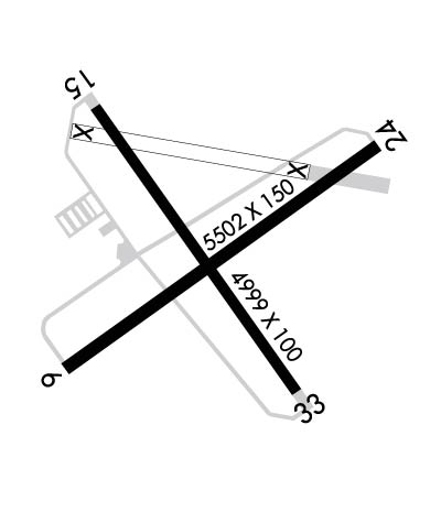
Runway Identifications
Runway Identification: 06/24Length: 5502 ft
Width: 150 ft
Surface: ASPHALT
Edge lights: Medium IntensityTreatment: GROOVED
| | Runway: 06 | | Runway: 24 |
| Mag heading: | 58° | Mag heading: | 238° |
| Rwy Slope: | .06% Up | Rwy Slope: | -.06% Down |
| Approach: | | Approach: | LOC/GS |
| Pattern: | Left Traffic | Pattern: | Left Traffic |
| Markings: | PRECISION INSTRUMENT | Markings: | PRECISION INSTRUMENT |
| Marking Condition: | GOOD | Marking Condition: | GOOD |
| Arresting Dev: | | Arresting Dev: | |
| Lat & Long: | N3945.1 W08451.0 | Lat. & Long.: | N3945.6 W08450.0 |
| Elev: | 1134.7 ft. MSL | Elev: | 1138.2 ft. MSL |
| TCH: | 26 ft. AGL | TCH: | 47 ft. AGL |
| Visual Glide Path: | 3.00 degrees | Visual Glide Path: | 3.00 degrees |
| Displaced Threshold: | 300 feet | Displaced Threshold: | No |
| Touchdown Zone: | YES | Touchdown Zone: | YES |
| Touchdown Elev.: | 1136.2 feet | Touchdown Elev.: | 1139.3 feet |
| Visual Glide Slope: | 4-Light PAPI on LEFT side of Runway | Visual Glide Slope: | 4-Light PAPI on LEFT side of Runway |
| RVR Equipment: | | RVR Equipment: | |
| RVV Equipment: | NO | RVV Equipment: | NO |
| Approach Lights: | | Approach Lights: | |
| REIL: | YES | REIL: | YES |
| Centerline Lights: | NO | Centerline Lights: | NO |
| Touchdown lights: | NO | Touchdown lights: | NO |
| Runway Category: | Runway with a Non-precision Approach having visibility minimums greater than 3/4 mile | Runway Category: | Precision Instrument Runway |
| Declared Distances: | TORA:5500' TODA:5500' ASDA:5500' LDA:5200' | Declared Distances: | TORA:5500' TODA:5500' ASDA:5500' LDA:5500' |
| Obstructions: | ROAD | Obstructions: | TREES |
| Marked: | NOT Marked/Lighted | Marked: | NOT Marked/Lighted |
| Clearance slope: | 6:1; APCH RATIO 34:1 TO DTHR. | Clearance slope: | 21:1; APCH RATIO 24:1 TO THR. |
| Obstruction height: | 18 feet AGL | Obstruction height: | 72 feet AGL |
| Dist. from runway: | 320 feet | Dist. from runway: | 1740 feet |
| Centerline offset: | 510 left of centerline | Centerline offset: | 730 feet right of centerline |
| Comments: | | Comments: | 10 FT CROPS 110 FT L & R OF RWY END CNTRLN. |
Runway Identification: 15/33Length: 4999 ft
Width: 100 ft
Surface: ASPHALT-FAIR CONDITION
Edge lights: Medium IntensityTreatment: NONE
| | Runway: 15 | | Runway: 33 |
| Mag heading: | 148° | Mag heading: | 328° |
| Rwy Slope: | .26% Up | Rwy Slope: | -.26% Down |
| Approach: | | Approach: | |
| Pattern: | Left Traffic | Pattern: | Left Traffic |
| Markings: | NONPRECISION INSTRUMENT | Markings: | NONPRECISION INSTRUMENT |
| Marking Condition: | GOOD | Marking Condition: | GOOD |
| Arresting Dev: | | Arresting Dev: | |
| Lat & Long: | N3945.7 W08450.9 | Lat. & Long.: | N3945.0 W08450.3 |
| Elev: | 1126.7 ft. MSL | Elev: | 1139.8 ft. MSL |
| TCH: | | TCH: | |
| Visual Glide Path: | | Visual Glide Path: | |
| Displaced Threshold: | No | Displaced Threshold: | No |
| Touchdown Zone: | YES | Touchdown Zone: | YES |
| Touchdown Elev.: | 1136.1 feet | Touchdown Elev.: | 1139.8 feet |
| Visual Glide Slope: | | Visual Glide Slope: | |
| RVR Equipment: | | RVR Equipment: | |
| RVV Equipment: | NO | RVV Equipment: | NO |
| Approach Lights: | | Approach Lights: | |
| REIL: | NO | REIL: | NO |
| Centerline Lights: | NO | Centerline Lights: | NO |
| Touchdown lights: | NO | Touchdown lights: | NO |
| Runway Category: | Runway with a Visual Approach | Runway Category: | Runway with a Non-precision Approach having visibility minimums greater than 3/4 mile |
| Declared Distances: | | Declared Distances: | |
| Obstructions: | | Obstructions: | TREES |
| Marked: | | Marked: | NOT Marked/Lighted |
| Clearance slope: | 20:1 | Clearance slope: | 35:1 |
| Obstruction height: | | Obstruction height: | 66 feet AGL |
| Dist. from runway: | | Dist. from runway: | 2550 feet |
| Centerline offset: | | Centerline offset: | 15 feet left of centerline |
| Comments: | 10 FT CROPS 105 FT L OF RWY END CNTRLN. | Comments: | 10 FT CROPS 100 FT L & R OF RWY END CNTRLN. |