
| ||||||||||||||||||||||||||||||||||||||||||||
| ||||||||||||||||||||||||||||||||||||||||||||
| Rwy | Rwy | |||||||
| 5003x100 | 5003' | 5003x100 | 5003' | |||||
| Runway ID | Single Wheel | Double Wheel | Double Tandem Wheel | Dual Double Wheel |
| 17/35 | 30,000 | 60,000 | N/A | N/A |
| These numbers are Advisory and are not limits. The Airport Manager should have more accurate Weight Limits | ||||
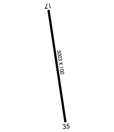 Airport Diagram might not be current. | |
| Facility Name: | LOUISIANA RGNL |
| City Name: | GONZALES |
| County: | ASCENSION |
| State abbrev: | LA |
| State Name: | LOUISIANA |
| Ownership: | PUBLICLY OWNED |
| Use: | OPEN TO THE PUBLIC |
| Owner's Name: | ASCENSION-ST JAMES ARPT &; TRANSPORTATION AUTHORITY. |
| Address: | 6255 AIRPORT INDUSTRIAL BLVD |
| GONZALES, LA 70737 | |
| Owner's Phone: | 225-644-1959 |
| Manager's Name: | JASON BALL |
| Address: | 6255 AIRPORT INDUSTRIAL BLVD |
| GONZALES, LA 70737 | |
| Phone: | 225-644-1959 |
| FAA Region: | SOUTHWEST |
| FAA Field Office: | LNM |
| Date | Sunrise | Sunset |
|---|---|---|
| 04/24/24 Wednesday | 6:27 | 19:37 |
| 04/25/24 Thursday | 6:26 | 19:38 |
| 04/26/24 Friday | 6:25 | 19:39 |
| 04/27/24 Saturday | 6:24 | 19:39 |
| 04/28/24 Sunday | 6:23 | 19:40 |
| 04/29/24 Monday | 6:22 | 19:41 |
| 04/30/24 Tuesday | 6:21 | 19:41 |
| 05/01/24 Wednesday | 6:20 | 19:42 |
| 05/02/24 Thursday | 6:19 | 19:43 |
| 05/03/24 Friday | 6:18 | 19:43 |
| 05/04/24 Saturday | 6:17 | 19:44 |
| 05/05/24 Sunday | 6:17 | 19:45 |
| 05/06/24 Monday | 6:16 | 19:45 |
| 05/07/24 Tuesday | 6:15 | 19:46 |
| Airport Attendance Schedule | 7 Days A Week 0800-1700 |
| Airport Status | OPERATIONAL (This Status can change at any time - please check NOTAMS) |
| Airport Lighting Schedule | DUSK-DAWN. MIRL RY 17/35 & REIL RYS 17 & 35 PRESET LOW INTST DUSK-DAWN; TO INCR INTST ACTVT - CTAF. |
| Airport Storage Available | Tie Downs, Hanger |
| Extra Services Available | Charter, Flight Instruction, Aircraft Rental |
| Wind Indicator | YES - (lighted) |
| Control Tower | NO |
| CTAF Frequency | 123.000 |
| Unicom Frequency | 123.000 |
| Rotating Beacon Color | WG |
| Segmented Circle | YES |
| Landing Fee |
| Airport Inspected | STATE - performed by STATE AERONAUTICAL PERSONNEL |
| Inspection Date | 02/27/2024 |
| Type of Fuel Available | Grade 100LL, JET A; -10100LL AVBL SELF SVC WITH CREDIT CARD. JET A AVAILABLE AFTER HOURS CALL 225-644-1959 |
| Airframe Repair Service | MINOR |
| Power Plant Repair Service | MINOR |
| Latitude | N3010.3 |
| Longitude | W09056.4 (ESTIMATED) |
| Arpt Elevation | 14ft (SURVEYED) |
| Magnetic Variation | 02E |
| 2 miles S | of GONZALES |
| Traffic Pattern Altitude | |
| Sectional Chart | NEW ORLEANS |
| Operations (Reported) | Yearly | Avg. Daily |
|---|---|---|
| General Aviation Transient | 25000 | 68 |
| General Aviation Local | 60000 | 164 |
| Air Taxi | 0 | 0 |
| Commerical | 0 | 0 |
| Commuter | 0 | 0 |
| Military | 1000 | 3 |
| Aircraft based on Field | |
|---|---|
| General Aviation Singles | 99 |
| General Aviation Multi | 10 |
| Jet Aircraft | 2 |
| General Aviation Helicopters | 7 |
| Military Aircraft | 0 |
| Gliders | 0 |
| Ultralights | 0 |
| FSS on field | NO |
| FSS tie-in | DE RIDDER |
| FSS Phone | 1-800-WX-BRIEF |
| Who issues Notams | DRI |
| Notam D service at airport | YES |
| ARTCC Name | HOUSTON |
| Airport Certification | |
| Aircraft Rescue & Firefighting Index | None |
| Airport of Entry | No |
| Custom Landing Rights | YES |
| Joint Civil/Military | No |
| Military Landing rights | No |
| NATIONAL PLAN OF INTEGRATED AIRPORT SYSTEMS (NPIAS) |
| GRANT AGREEMENTS UNDER FAAP/ADAP/AIP |
| ASSURANCES PURSUANT TO TITLE VI, CIVIL RIGHTS ACT OF 1964 |
| GCO AVBL ON FREQ 135.075 THRU BATON ROUGE APCH & DE RIDDER FSS. |
| DEER ON & INVOF ARPT. |
| FOR CD IF UNA VIA GCO CTC BATON ROUGE APCH AT 225-354-2142 OR HOUSTON ARTCC AT 281-230-5622. |
Airport Communications & Frequencies:
| |||||||||||||||||
| Runway: 17 | Runway: 35 | ||
| Mag heading: | 169° | Mag heading: | 349° |
| Rwy Slope: | .02% Up | Rwy Slope: | -.02% Down |
| Approach: | Approach: | ||
| Pattern: | Left Traffic | Pattern: | Left Traffic |
| Markings: | NONPRECISION INSTRUMENT | Markings: | NONPRECISION INSTRUMENT |
| Marking Condition: | GOOD | Marking Condition: | GOOD |
| Arresting Dev: | Arresting Dev: | ||
| Lat & Long: | N3010.7 W09056.5 | Lat. & Long.: | N3009.9 W09056.4 |
| Elev: | 12.4 ft. MSL | Elev: | 13.6 ft. MSL |
| TCH: | 50 ft. AGL | TCH: | 50 ft. AGL |
| Visual Glide Path: | 3.00 degrees | Visual Glide Path: | 3.00 degrees |
| Displaced Threshold: | No | Displaced Threshold: | No |
| Touchdown Zone: | YES | Touchdown Zone: | YES |
| Touchdown Elev.: | 13.0 feet | Touchdown Elev.: | 13.9 feet |
| Visual Glide Slope: | 2-Light PAPI on LEFT side of Runway | Visual Glide Slope: | 2-Light PAPI on LEFT side of Runway |
| RVR Equipment: | RVR Equipment: | ||
| RVV Equipment: | NO | RVV Equipment: | NO |
| Approach Lights: | Approach Lights: | ||
| REIL: | YES | REIL: | YES |
| Centerline Lights: | NO | Centerline Lights: | NO |
| Touchdown lights: | NO | Touchdown lights: | NO |
| Runway Category: | Runway with a Non-precision Approach having visibility minimums greater than 3/4 mile | Runway Category: | Runway with a Non-precision Approach having visibility minimums greater than 3/4 mile |
| Declared Distances: | Declared Distances: | ||
| Obstructions: | TREES | Obstructions: | TREES |
| Marked: | NOT Marked/Lighted | Marked: | NOT Marked/Lighted |
| Clearance slope: | 26:1 | Clearance slope: | 24:1 |
| Obstruction height: | 97 feet AGL | Obstruction height: | 51 feet AGL |
| Dist. from runway: | 2770 feet | Dist. from runway: | 1454 feet |
| Centerline offset: | 96 right of centerline | Centerline offset: | 50 feet right of centerline |
| Comments: | Comments: |
