Click here for more info on on SMS!

KRED

RED LODGE
RED LODGE
MT
Time Zone: Mountain
Lat: N 4511.1
Long: W 10915.5
Elev: 5762
Var: -15
Longest Runway: 4000
CTAF: 122.9

FBO & Flight Services info for KRED

FBOs: Update your Fuel Prices

AIRPORT
-
Freq: 122.9
Service
Jet
100LL
SAF
MoGas
Fuel Avail: NO FUEL AVAILABLE
Full        Last Update: 04/22/2024 05:24:32

Self        
If you are an FBO, call 1-203-262-1700 to update your info or email: FltPlan.Advertising@garmin.com
Advertise your FBO on FltPlan.com

Runway & Approach Info for KRED
Rwy
Length
Land Dist**
Approach*
  Rwy
Length
Land Dist**
Approach*
16
4000x75  4000'          
 
  
34
  4000x75  4000'          
 
 * only ILS, LOC, LDA, and SDF approaches to a specific runway are shown
** For any Declared Landing Distance Available, please see A/FD or Approach plates
Runway Weight Capability (lbs.) Help
Runway IDSingle WheelDouble WheelDouble Tandem WheelDual Double Wheel
16/344,0006,000N/AN/A
These numbers are Advisory and are not limits.   The Airport Manager should have more accurate Weight Limits
Approach Charts
FltPlan does not have IFR approach charts available for KRED.
Current Weather/Notams
Customs Information Send updates to Support@FltPlan.com
Customs Not Available
Database effective 05/16/2024
Airport Diagram of KRED
Airport Diagram might not be current.

Facility Name: RED LODGE
City Name: RED LODGE
County: CARBON
State abbrev: MT
State Name: MONTANA
   
Ownership: PUBLICLY OWNED
Use: OPEN TO THE PUBLIC
Owner's Name: CITY OF RED LODGE- CARBON CO
Address: P.O. BOX 887
 RED LODGE, MT 59068
Owner's Phone: 406-446-1595
  
Manager's Name: JEFFREY A WISE
Address: PO BOX 887
 RED LODGE, MT 59068
Phone: 406-425-3143
   
FAA Region: NORTHWEST MOUNTAIN
FAA Field Office: HLN


Sunrise / Sunset times for RED LODGE

DateSunriseSunset
04/22/24 Monday6:1920:13
04/23/24 Tuesday6:1720:14
04/24/24 Wednesday6:1520:15
04/25/24 Thursday6:1420:17
04/26/24 Friday6:1220:18
04/27/24 Saturday6:1120:19
04/28/24 Sunday6:0920:20
04/29/24 Monday6:0820:22
04/30/24 Tuesday6:0620:23
05/01/24 Wednesday6:0520:24
05/02/24 Thursday6:0320:25
05/03/24 Friday6:0220:27
05/04/24 Saturday6:0020:28
05/05/24 Sunday5:5920:29

Airport Facilities

Airport Attendance ScheduleUNATTENDED
Airport Status OPERATIONAL (This Status can change at any time - please check NOTAMS)
Airport Lighting ScheduleACTVT MIRL RY 16/34 & VASI RY 16 - CTAF.
Airport Storage AvailableTie Downs
Extra Services AvailableFlight Instruction
Wind IndicatorYES - (lighted)
Control TowerNO
CTAF Frequency122.900
Unicom Frequency
Rotating Beacon ColorWG
Segmented CircleYES
Landing FeeNO

Airport Inspection Data

Airport InspectedSTATE - performed by STATE AERONAUTICAL PERSONNEL
Inspection Date05/17/2022

Airport Services

Type of Fuel AvailableGrade 100LL; -1024 HR CREDIT CARD 100LL.
Airframe Repair ServiceNONE
Power Plant Repair ServiceNONE

Geographic Data

LatitudeN4511.1
LongitudeW10915.5 (ESTIMATED)
Arpt Elevation5762ft (SURVEYED)
Magnetic Variation15E
1 miles NWof RED LODGE
Traffic Pattern Altitude
Sectional ChartGREAT FALLS

Aircraft Data

Operations (Reported)YearlyAvg. Daily
General Aviation Transient 15004
General Aviation Local 22006
Air Taxi 2001
Commerical 00
Commuter 00
Military 500
Aircraft based on Field
General Aviation Singles 26
General Aviation Multi 1
Jet Aircraft 0
General Aviation Helicopters 2
Military Aircraft 0
Gliders 0
Ultralights 0

FAA Services

FSS on field NO
FSS tie-in GREAT FALLS
FSS Phone 1-800-WX-BRIEF
Who issues Notams GTF
Notam D service at airport YES
ARTCC Name SALT LAKE CITY

Federal Status

Airport Certification
Aircraft Rescue & Firefighting IndexNone
Airport of EntryNo
Custom Landing RightsNo
Joint Civil/MilitaryNo
Military Landing rightsYES

Federal Agreements

NATIONAL PLAN OF INTEGRATED AIRPORT SYSTEMS (NPIAS)
GRANT AGREEMENTS UNDER FAAP/ADAP/AIP
ASSURANCES PURSUANT TO TITLE VI, CIVIL RIGHTS ACT OF 1964

Remarks

WILDLIFE ON & INVOF ARPT.
DIGIWX WX - 2 CLICKS ON 122.725.
FOR CD CTC SALT LAKE ARTCC AT 801-320-2568.
NEW CARD READER FOR FUEL
RWY 16/3 4 PAVEMENT CRACKING AND ERODING AT EDGES, LOOSE GRVL ON RWY SFC.
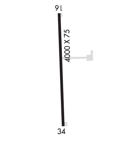
Runway Identifications
Runway Identification: 16/34
Length: 4000 ft
Width: 75 ft
Surface: ASPHALT-POOR CONDITION
Edge lights: Medium Intensity

Treatment: NONE

 Runway: 16   Runway: 34
Mag heading: 162°Mag heading: 342°
Rwy Slope: 1.63% UpRwy Slope: -1.63% Down
Approach: Approach:
Pattern: Left TrafficPattern: Left Traffic
Markings: BASICMarkings: BASIC
Marking Condition: POOR; MRKGS FADED & MSG SECTIONS.Marking Condition: POOR; MRKGS FADED.
Arresting Dev: Arresting Dev:
Lat & Long: N4511.4  W10915.5Lat. & Long.: N4510.8  W10915.4
Elev: 5696.8 ft. MSLElev: 5762.0 ft. MSL
TCH: 27 ft. AGLTCH:
Visual Glide Path: 3.00 degreesVisual Glide Path:
Displaced Threshold: NoDisplaced Threshold: No
Touchdown Zone: YESTouchdown Zone: YES
Touchdown Elev.: 5696.8 feetTouchdown Elev.: 5762.0 feet
Visual Glide Slope: 2-Box VASI on LEFT side of RunwayVisual Glide Slope:
RVR Equipment: RVR Equipment:
RVV Equipment: NORVV Equipment: NO
Approach Lights: Approach Lights:
REIL: NOREIL: NO
Centerline Lights: NOCenterline Lights: NO
Touchdown lights: NOTouchdown lights: NO
Runway Category: Runway with a Visual ApproachRunway Category: Runway with a Visual Approach
Declared Distances: Declared Distances:
Obstructions: TREEObstructions: ROAD
Marked: NOT Marked/LightedMarked: NOT Marked/Lighted
Clearance slope: 14:1Clearance slope: 8:1
Obstruction height: 14 feet AGLObstruction height: 10 feet AGL
Dist. from runway: 408 feetDist. from runway: 288 feet
Centerline offset: Centerline offset: 50B
Comments: Comments: +10 FT RD 110 FT R; +4 FT FENCE 100 FT R; BOTH X EXTD RWY CNTRLN 288 FT FM THR. ALSO STEEP TRRN DROPOFF TO -400 FT APRXLY 150 FT R.
C:2/P: