Current Weather/Notams (Metars, TAFs, Notams, NWS Forecast, PIREPS, and nearby weather)
Customs Information Send updates to Support@FltPlan.com
Customs Not Available
Database effective 05/16/2024
Airport Diagram might not be current.
|
| Facility Name: | RED OAK MUNI |
| City Name: | RED OAK |
| County: | MONTGOMERY |
| State abbrev: | IA |
| State Name: | IOWA |
| | |
| Ownership: | PUBLICLY OWNED |
| Use: | OPEN TO THE PUBLIC |
| Owner's Name: | CITY OF RED OAK; NICK HILDRETH - CHMN - 402-658-1782 |
| Address: | 601 6TH ST |
| | RED OAK, IA 51566 |
| Owner's Phone: | 712-370-1511 |
| | |
| Manager's Name: | KEVIN MCGREW |
| Address: | 1674 200TH ST |
| | RED OAK, IA 51566 |
| Phone: | 712-370-1511 |
| | |
| FAA Region: | CENTRAL |
| FAA Field Office: | NONE |
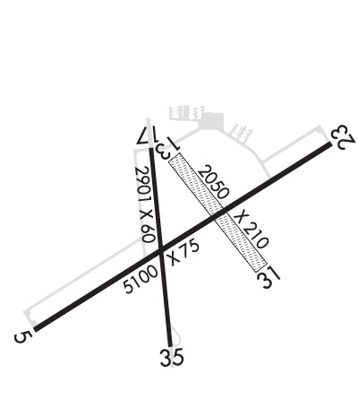
Runway Identifications
Runway Identification: 05/23Length: 5100 ft
Width: 75 ft
Surface: CONCRETE-GOOD CONDITION
Edge lights: Medium IntensityTreatment: NONE
Weight: PCN 9 /R/C/W/T
| | Runway: 05 | | Runway: 23 |
| Mag heading: | 54° | Mag heading: | 234° |
| Rwy Slope: | .06% Up | Rwy Slope: | -.06% Down |
| Approach: | | Approach: | |
| Pattern: | Left Traffic | Pattern: | Left Traffic |
| Markings: | NONPRECISION INSTRUMENT | Markings: | NONPRECISION INSTRUMENT |
| Marking Condition: | GOOD | Marking Condition: | GOOD |
| Arresting Dev: | | Arresting Dev: | |
| Lat & Long: | N4100.4 W09516.0 | Lat. & Long.: | N4100.9 W09515.1 |
| Elev: | 1042.1 ft. MSL | Elev: | 1045.0 ft. MSL |
| TCH: | 26 ft. AGL | TCH: | 33 ft. AGL |
| Visual Glide Path: | 3.00 degrees | Visual Glide Path: | 3.00 degrees |
| Displaced Threshold: | 1000 feet | Displaced Threshold: | No |
| Touchdown Zone: | YES | Touchdown Zone: | YES |
| Touchdown Elev.: | 1042.8 feet | Touchdown Elev.: | 1045.0 feet |
| Visual Glide Slope: | 2-Light PAPI on LEFT side of Runway | Visual Glide Slope: | 2-Light PAPI on LEFT side of Runway |
| RVR Equipment: | | RVR Equipment: | |
| RVV Equipment: | NO | RVV Equipment: | NO |
| Approach Lights: | | Approach Lights: | |
| REIL: | YES | REIL: | YES |
| Centerline Lights: | NO | Centerline Lights: | NO |
| Touchdown lights: | NO | Touchdown lights: | NO |
| Runway Category: | Runway with a Non-precision Approach having visibility minimums greater than 3/4 mile | Runway Category: | Runway with a Visual Approach |
| Declared Distances: | | Declared Distances: | |
| Obstructions: | RR | Obstructions: | TREES |
| Marked: | NOT Marked/Lighted | Marked: | NOT Marked/Lighted |
| Clearance slope: | 25:1 | Clearance slope: | 21:1 |
| Obstruction height: | 60 feet AGL | Obstruction height: | 76 feet AGL |
| Dist. from runway: | 1752 feet | Dist. from runway: | 1796 feet |
| Centerline offset: | | Centerline offset: | 111 feet left of centerline |
| Comments: | | Comments: | |
Runway Identification: 13/31Length: 2050 ft
Width: 210 ft
Surface: GRASS-FAIR CONDITION
Edge lights: Treatment: NONE
| | Runway: 13 | | Runway: 31 |
| Mag heading: | 138° | Mag heading: | 318° |
| Rwy Slope: | -.18% Down | Rwy Slope: | .18% Up |
| Approach: | | Approach: | |
| Pattern: | Left Traffic | Pattern: | Left Traffic |
| Markings: | | Markings: | |
| Marking Condition: | 13/31 ENDS & SIDES MARKED WITH YELLOW CONES. | Marking Condition: | |
| Arresting Dev: | | Arresting Dev: | |
| Lat & Long: | N4100.8 W09515.6 | Lat. & Long.: | N4100.6 W09515.3 |
| Elev: | 1042.4 ft. MSL | Elev: | 1038.7 ft. MSL |
| TCH: | | TCH: | |
| Visual Glide Path: | | Visual Glide Path: | |
| Displaced Threshold: | No | Displaced Threshold: | No |
| Touchdown Zone: | YES | Touchdown Zone: | YES |
| Touchdown Elev.: | 1042.4 feet | Touchdown Elev.: | 1042.4 feet |
| Visual Glide Slope: | | Visual Glide Slope: | |
| RVR Equipment: | | RVR Equipment: | |
| RVV Equipment: | NO | RVV Equipment: | NO |
| Approach Lights: | | Approach Lights: | |
| REIL: | NO | REIL: | NO |
| Centerline Lights: | NO | Centerline Lights: | NO |
| Touchdown lights: | NO | Touchdown lights: | NO |
| Runway Category: | Runway with a Visual Approach | Runway Category: | Runway with a Visual Approach |
| Declared Distances: | | Declared Distances: | |
| Obstructions: | ROAD | Obstructions: | POLE |
| Marked: | NOT Marked/Lighted | Marked: | NOT Marked/Lighted |
| Clearance slope: | 33:1 | Clearance slope: | 23:1 |
| Obstruction height: | 27 feet AGL | Obstruction height: | 51 feet AGL |
| Dist. from runway: | 900 feet | Dist. from runway: | 1210 feet |
| Centerline offset: | | Centerline offset: | |
| Comments: | | Comments: | |
Runway Identification: 17/35Length: 2901 ft
Width: 60 ft
Surface: CONCRETE-FAIR CONDITION
Edge lights: Medium IntensityTreatment: NONE
Weight: PCN 8 /R/C/W/T
| | Runway: 17 | | Runway: 35 |
| Mag heading: | 170° | Mag heading: | 350° |
| Rwy Slope: | -.21% Down | Rwy Slope: | .21% Up |
| Approach: | | Approach: | |
| Pattern: | Left Traffic | Pattern: | Left Traffic |
| Markings: | NONPRECISION INSTRUMENT | Markings: | NONPRECISION INSTRUMENT |
| Marking Condition: | GOOD | Marking Condition: | GOOD |
| Arresting Dev: | | Arresting Dev: | |
| Lat & Long: | N4100.9 W09515.6 | Lat. & Long.: | N4100.4 W09515.6 |
| Elev: | 1044.8 ft. MSL | Elev: | 1038.7 ft. MSL |
| TCH: | 32 ft. AGL | TCH: | 33 ft. AGL |
| Visual Glide Path: | 3.00 degrees | Visual Glide Path: | 3.00 degrees |
| Displaced Threshold: | No | Displaced Threshold: | No |
| Touchdown Zone: | YES | Touchdown Zone: | YES |
| Touchdown Elev.: | 1044.8 feet | Touchdown Elev.: | 1044.8 feet |
| Visual Glide Slope: | 2-Light PAPI on LEFT side of Runway | Visual Glide Slope: | 2-Light PAPI on LEFT side of Runway |
| RVR Equipment: | | RVR Equipment: | |
| RVV Equipment: | NO | RVV Equipment: | NO |
| Approach Lights: | | Approach Lights: | |
| REIL: | YES | REIL: | YES |
| Centerline Lights: | NO | Centerline Lights: | NO |
| Touchdown lights: | NO | Touchdown lights: | NO |
| Runway Category: | Runway with a Non-precision Approach | Runway Category: | Runway with a Non-precision Approach |
| Declared Distances: | | Declared Distances: | |
| Obstructions: | ROAD | Obstructions: | PLINE |
| Marked: | NOT Marked/Lighted | Marked: | NOT Marked/Lighted |
| Clearance slope: | 20:1 | Clearance slope: | 21:1 |
| Obstruction height: | 23 feet AGL | Obstruction height: | 44 feet AGL |
| Dist. from runway: | 680 feet | Dist. from runway: | 1124 feet |
| Centerline offset: | | Centerline offset: | 83 feet right of centerline |
| Comments: | | Comments: | |


