Current Weather/Notams (Metars, TAFs, Notams, NWS Forecast, PIREPS, and nearby weather)
Customs Information Send updates to Support@FltPlan.com
Customs Not Available
Database effective 05/16/2024
Airport Diagram might not be current.
|
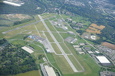
| Facility Name: | READING RGNL/CARL A SPAATZ FLD |
| City Name: | READING |
| County: | BERKS |
| State abbrev: | PA |
| State Name: | PENNSYLVANIA |
| | |
| Ownership: | PUBLICLY OWNED |
| Use: | OPEN TO THE PUBLIC |
| Owner's Name: | READING REGIONAL ARPT AUTH. |
| Address: | 2501 BERNVILLE RD |
| | READING, PA 19605 |
| Owner's Phone: | 610-372-4666 |
| | |
| Manager's Name: | ZACKARY J. TEMPESCO |
| Address: | 2501 BERNVILLE RD |
| | READING, PA 19605 |
| Phone: | 610-372-4666 |
| | |
| FAA Region: | EASTERN |
| FAA Field Office: | HAR |
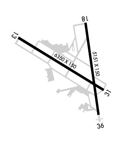
Runway Identifications
Runway Identification: 13/31Length: 6350 ft
Width: 150 ft
Surface: ASPHALT-GOOD CONDITION
Edge lights: High IntensityTreatment: GROOVED
Weight: PCN 60 /F/C/X/U
| | Runway: 13 | | Runway: 31 |
| Mag heading: | 133° | Mag heading: | 313° |
| Rwy Slope: | -.22% Down | Rwy Slope: | .22% Up |
| Approach: | ILS/DME | Approach: | |
| Pattern: | Left Traffic | Pattern: | Left Traffic |
| Markings: | PRECISION INSTRUMENT | Markings: | PRECISION INSTRUMENT |
| Marking Condition: | GOOD | Marking Condition: | GOOD |
| Arresting Dev: | EMAS; ARRESTING GEAR/SYSTEM: ENGINEERED MATERIAL ARRESTING SYSTEM (EMAS) 255 FT IN LENGTH BY 170 FT IN WIDTH LOCATED AT DEP END RWY 13. | Arresting Dev: | |
| Lat & Long: | N4023.0 W07558.7 | Lat. & Long.: | N4022.5 W07557.5 |
| Elev: | 343.4 ft. MSL | Elev: | 329.7 ft. MSL |
| TCH: | 45 ft. AGL | TCH: | |
| Visual Glide Path: | 3.00 degrees | Visual Glide Path: | |
| Displaced Threshold: | No | Displaced Threshold: | No |
| Touchdown Zone: | YES | Touchdown Zone: | YES |
| Touchdown Elev.: | 343.4 feet | Touchdown Elev.: | 329.7 feet |
| Visual Glide Slope: | 4-Light PAPI on LEFT side of Runway; PAPI UNUSBL BYD 3 DEGS LEFT OF CNTRLN. | Visual Glide Slope: | |
| RVR Equipment: | | RVR Equipment: | |
| RVV Equipment: | NO | RVV Equipment: | NO |
| Approach Lights: | | Approach Lights: | |
| REIL: | YES | REIL: | YES |
| Centerline Lights: | NO | Centerline Lights: | NO |
| Touchdown lights: | NO | Touchdown lights: | NO |
| Runway Category: | Precision Instrument Runway | Runway Category: | Runway with a Visual Approach |
| Declared Distances: | TORA:6350' TODA:6350' ASDA:6350' LDA:6350' | Declared Distances: | TORA:6350' TODA:6350' ASDA:6350' LDA:6350' |
| Obstructions: | TREES | Obstructions: | |
| Marked: | NOT Marked/Lighted | Marked: | |
| Clearance slope: | 23:1 | Clearance slope: | 20:1 |
| Obstruction height: | 317 feet AGL | Obstruction height: | |
| Dist. from runway: | 7661 feet | Dist. from runway: | |
| Centerline offset: | 1213 left of centerline | Centerline offset: | |
| Comments: | | Comments: | |
Runway Identification: 18/36Length: 5151 ft
Width: 150 ft
Surface: ASPHALT-GOOD CONDITION
Edge lights: High IntensityTreatment: GROOVED
Weight: PCN 60 /F/C/X/U
| | Runway: 18 | | Runway: 36 |
| Mag heading: | 184° | Mag heading: | 4° |
| Rwy Slope: | 1.01% Up | Rwy Slope: | -1.01% Down |
| Approach: | | Approach: | ILS |
| Pattern: | Left Traffic | Pattern: | Left Traffic |
| Markings: | PRECISION INSTRUMENT | Markings: | PRECISION INSTRUMENT |
| Marking Condition: | GOOD | Marking Condition: | GOOD |
| Arresting Dev: | | Arresting Dev: | |
| Lat & Long: | N4023.1 W07557.8 | Lat. & Long.: | N4022.2 W07557.6 |
| Elev: | 290.4 ft. MSL | Elev: | 342.3 ft. MSL |
| TCH: | 56 ft. AGL | TCH: | |
| Visual Glide Path: | 3.00 degrees | Visual Glide Path: | |
| Displaced Threshold: | No | Displaced Threshold: | No |
| Touchdown Zone: | YES | Touchdown Zone: | YES |
| Touchdown Elev.: | 318.4 feet | Touchdown Elev.: | 343.3 feet |
| Visual Glide Slope: | 4-Light PAPI on LEFT side of Runway | Visual Glide Slope: | |
| RVR Equipment: | | RVR Equipment: | TOUCHDOWN |
| RVV Equipment: | NO | RVV Equipment: | YES |
| Approach Lights: | | Approach Lights: | MALSF - 1,400 foot medium intensity approach lighting system with sequenced flashers |
| REIL: | NO | REIL: | NO |
| Centerline Lights: | NO | Centerline Lights: | NO |
| Touchdown lights: | NO | Touchdown lights: | NO |
| Runway Category: | Runway with a Non-precision Approach having visibility minimums greater than 3/4 mile | Runway Category: | Precision Instrument Runway |
| Declared Distances: | TORA:5151' TODA:5151' ASDA:5151' LDA:5151' | Declared Distances: | TORA:5151' TODA:5151' ASDA:5151' LDA:5151' |
| Obstructions: | TREES | Obstructions: | TREES |
| Marked: | NOT Marked/Lighted | Marked: | NOT Marked/Lighted |
| Clearance slope: | 12:1 | Clearance slope: | 32:1 |
| Obstruction height: | 58 feet AGL | Obstruction height: | 18 feet AGL |
| Dist. from runway: | 893 feet | Dist. from runway: | 769 feet |
| Centerline offset: | 580 right of centerline | Centerline offset: | 499 feet right of centerline |
| Comments: | | Comments: | |