Current Weather/Notams (Metars, TAFs, Notams, NWS Forecast, PIREPS, and nearby weather)
Customs Information Send updates to Support@FltPlan.com
Customs Not Available
Database effective 05/16/2024
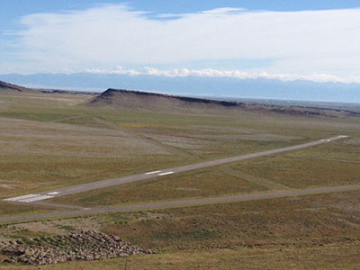
Airport Diagram might not be current.
|
| Facility Name: | ASTRONAUT KENT ROMINGER |
| City Name: | DEL NORTE |
| County: | RIO GRANDE |
| State abbrev: | CO |
| State Name: | COLORADO |
| | |
| Ownership: | PUBLICLY OWNED |
| Use: | OPEN TO THE PUBLIC |
| Owner's Name: | RIO GRANDE COUNTY |
| Address: | 925 6TH STREET, RM 207 |
| | DEL NORTE, CO 81132 |
| Owner's Phone: | 719-657-2744 |
| | |
| Manager's Name: | BRIAN BURRELL |
| Address: | 1 BRAVO TAXIWAY |
| | DEL NORTE, CO 81132 |
| Phone: | 719-221-6677 |
| | |
| FAA Region: | NORTHWEST MOUNTAIN |
| FAA Field Office: | DEN |
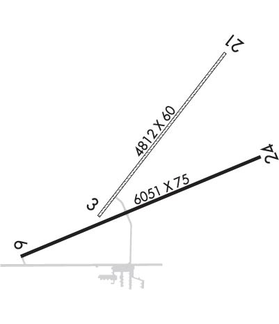
Runway Identifications
Runway Identification: 03/21Length: 4812 ft
Width: 60 ft
Surface: GRASS-POOR CONDITION
Edge lights: Treatment: NONE
| | Runway: 03 | | Runway: 21 |
| Mag heading: | 30° | Mag heading: | 210° |
| Rwy Slope: | .13% Up | Rwy Slope: | -.13% Down |
| Approach: | | Approach: | |
| Pattern: | Left Traffic | Pattern: | Left Traffic |
| Markings: | | Markings: | |
| Marking Condition: | | Marking Condition: | |
| Arresting Dev: | | Arresting Dev: | |
| Lat & Long: | N3742.7 W10621.4 | Lat. & Long.: | N3743.3 W10620.8 |
| Elev: | 7925.9 ft. MSL | Elev: | 7932.1 ft. MSL |
| TCH: | | TCH: | |
| Visual Glide Path: | | Visual Glide Path: | |
| Displaced Threshold: | No | Displaced Threshold: | No |
| Touchdown Zone: | YES | Touchdown Zone: | YES |
| Touchdown Elev.: | 7926.3 feet | Touchdown Elev.: | 7932.1 feet |
| Visual Glide Slope: | | Visual Glide Slope: | |
| RVR Equipment: | | RVR Equipment: | |
| RVV Equipment: | NO | RVV Equipment: | NO |
| Approach Lights: | | Approach Lights: | |
| REIL: | NO | REIL: | NO |
| Centerline Lights: | NO | Centerline Lights: | NO |
| Touchdown lights: | NO | Touchdown lights: | NO |
| Runway Category: | Runway with a Visual Approach | Runway Category: | Runway with a Visual Approach |
| Declared Distances: | | Declared Distances: | |
| Obstructions: | Unknown | Obstructions: | ROAD |
| Marked: | NOT Marked/Lighted | Marked: | NOT Marked/Lighted |
| Clearance slope: | 50:1 | Clearance slope: | 6:1 |
| Obstruction height: | 0 feet AGL | Obstruction height: | 19 feet AGL |
| Dist. from runway: | 0 feet | Dist. from runway: | 122 feet |
| Centerline offset: | | Centerline offset: | 57 feet right of centerline |
| Comments: | | Comments: | |
Runway Identification: 06/24Length: 6051 ft
Width: 75 ft
Surface: ASPHALT-GOOD CONDITION
Edge lights: Medium IntensityTreatment: NONE
| | Runway: 06 | | Runway: 24 |
| Mag heading: | 59° | Mag heading: | 239° |
| Rwy Slope: | -1.09% Down | Rwy Slope: | 1.09% Up |
| Approach: | | Approach: | |
| Pattern: | Right Traffic | Pattern: | Left Traffic |
| Markings: | NONPRECISION INSTRUMENT | Markings: | NONPRECISION INSTRUMENT |
| Marking Condition: | GOOD | Marking Condition: | GOOD |
| Arresting Dev: | | Arresting Dev: | |
| Lat & Long: | N3742.5 W10621.7 | Lat. & Long.: | N3742.9 W10620.6 |
| Elev: | 7955.4 ft. MSL | Elev: | 7889.6 ft. MSL |
| TCH: | 43 ft. AGL | TCH: | 40 ft. AGL |
| Visual Glide Path: | 4.00 degrees | Visual Glide Path: | 3.00 degrees |
| Displaced Threshold: | No | Displaced Threshold: | No |
| Touchdown Zone: | YES | Touchdown Zone: | YES |
| Touchdown Elev.: | 7955.4 feet | Touchdown Elev.: | 7913.2 feet |
| Visual Glide Slope: | 2-Light PAPI on LEFT side of Runway; UNUSBL BYD 5 DEG RIGHT OF CRS. | Visual Glide Slope: | 2-Light PAPI on LEFT side of Runway |
| RVR Equipment: | | RVR Equipment: | |
| RVV Equipment: | NO | RVV Equipment: | NO |
| Approach Lights: | | Approach Lights: | |
| REIL: | YES | REIL: | YES |
| Centerline Lights: | NO | Centerline Lights: | NO |
| Touchdown lights: | NO | Touchdown lights: | NO |
| Runway Category: | Runway with a Visual Approach | Runway Category: | Runway with a Visual Approach |
| Declared Distances: | | Declared Distances: | |