Click here for more info on on SMS!

KRCM

SKYHAVEN
WARRENSBURG
MO
Time Zone: Central
Lat: N 3847.1
Long: W 09348.2
Elev: 798
Var: -01
Longest Runway: 4206
AWOS: 119.57
CTAF: 123.0

FBO & Flight Services info for KRCM

FBOs: Update your Fuel Prices

  click here  
The University of Central Missouri's Max B. Swisher Skyhaven Airport is the only university-owned airport in Missouri. Located three miles northwest of Warrensburg, the airport serves as the training facility for UCM's nationally recognized aviation program. It is also the community airport for Johnson County, MO.
Ph: 660-543-4921 Fax: 660-543-8670 Freq: 123.0WebsiteE-Mail
                               
Service
Jet
100LL
SAF
MoGas
Fuel Avail: PRIST PREMIXED
Full6.555.50    Caution: Fuel prices have not been updated in 32 days.
Last Update: 03/25/2024 09:29

Single Point & GPU Services Now Available
Self        
Misc. Info: Address: 160 NW 251,   WARRENSBURG, MO 64093

AWOSPh: 660-543-4335
-
Freq: 119.57  
If you are an FBO, call 1-203-262-1700 to update your info or email: FltPlan.Advertising@garmin.com
Advertise your FBO on FltPlan.com

Runway & Approach Info for KRCM
Rwy
Length
Land Dist**
Approach*
  Rwy
Length
Land Dist**
Approach*
01
4206x75  4206'          
 
  
19
  4206x75  4206'          
 
14
2801x60  2801'          
 
  
32
  2801x60  2801'          
 
 * only ILS, LOC, LDA, and SDF approaches to a specific runway are shown
** For any Declared Landing Distance Available, please see A/FD or Approach plates
Runway Weight Capability (lbs.) Help
Runway IDSingle WheelDouble WheelDouble Tandem WheelDual Double Wheel
01/1921,00026,000N/AN/A
14/3212,500N/AN/AN/A
These numbers are Advisory and are not limits.   The Airport Manager should have more accurate Weight Limits
Approach Charts
Approaches    
Current Weather/Notams
Customs Information Send updates to Support@FltPlan.com
Customs Not Available
Database effective 05/16/2024
Airport Diagram of KRCM
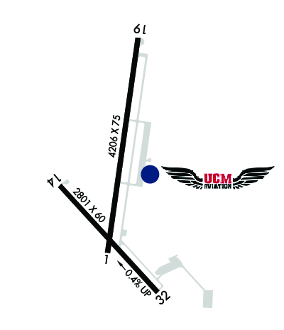
Airport Diagram might not be current.

Facility Name: SKYHAVEN
City Name: WARRENSBURG
County: JOHNSON
State abbrev: MO
State Name: MISSOURI
   
Ownership: PUBLICLY OWNED
Use: OPEN TO THE PUBLIC
Owner's Name: UNIV. OF CENTRAL MISSOURI
Address: T.R. GAINES, BLDG 210
 WARRENSBURG, MO 64093
Owner's Phone: 660-543-4921
  
Manager's Name: DAN DIETZ
Address: UNIVERSITY OF CENTRAL MISSOURI, 281 N.W. 50 HWY
 WARRENSBURG, MO 64093
Phone: 660-422-1110; 660-422-1110
   
FAA Region: CENTRAL
FAA Field Office: NONE


Sunrise / Sunset times for SKYHAVEN

DateSunriseSunset
04/25/24 Thursday6:2420:03
04/26/24 Friday6:2320:04
04/27/24 Saturday6:2220:05
04/28/24 Sunday6:2020:05
04/29/24 Monday6:1920:06
04/30/24 Tuesday6:1820:07
05/01/24 Wednesday6:1720:08
05/02/24 Thursday6:1520:09
05/03/24 Friday6:1420:10
05/04/24 Saturday6:1320:11
05/05/24 Sunday6:1220:12
05/06/24 Monday6:1120:13
05/07/24 Tuesday6:1020:14
05/08/24 Wednesday6:0920:15

Airport Facilities

Airport Attendance ScheduleSAT 0800-1700, SUN 0800-1600, MON-FRI 0700-1900
Airport Status OPERATIONAL (This Status can change at any time - please check NOTAMS)
Airport Lighting ScheduleACTVT REIL RWY 14 & 32; PAPI RWY 01 & 19; MIRL RWY 01/19 & 14/32 - CTAF.
Airport Storage AvailableTie Downs
Extra Services AvailableCharter, Glider, Flight Instruction, Aircraft Rental, Annual Surveying, Glider Towing
Wind IndicatorYES - (lighted)
Control TowerNO
CTAF Frequency123.000
Unicom Frequency123.000
Rotating Beacon ColorWG
Segmented CircleYES
Landing FeeNO

Airport Inspection Data

Airport InspectedSTATE - performed by STATE AERONAUTICAL PERSONNEL
Inspection Date06/29/2023

Airport Services

Type of Fuel AvailableGrade 100LL, JET A (freeze point -40C)
Airframe Repair ServiceMINOR
Power Plant Repair ServiceMINOR

Geographic Data

LatitudeN3847.1
LongitudeW09348.2 (ESTIMATED)
Arpt Elevation797ft (SURVEYED)
Magnetic Variation01E
3 miles NWof WARRENSBURG
Traffic Pattern Altitude
Sectional ChartKANSAS CITY

Aircraft Data

Operations (Reported)YearlyAvg. Daily
General Aviation Transient 24007
General Aviation Local 2700074
Air Taxi 250
Commerical 00
Commuter 00
Military 3001
Aircraft based on Field
General Aviation Singles 49
General Aviation Multi 3
Jet Aircraft 0
General Aviation Helicopters 0
Military Aircraft 0
Gliders 1
Ultralights 0

FAA Services

FSS on field NO
FSS tie-in COLUMBIA
FSS Phone 1-800-WX-BRIEF
Who issues Notams COU
Notam D service at airport YES
ARTCC Name KANSAS CITY

Federal Status

Airport Certification
Aircraft Rescue & Firefighting IndexNone
Airport of EntryNo
Custom Landing RightsNo
Joint Civil/MilitaryNo
Military Landing rightsYES

Federal Agreements

NATIONAL PLAN OF INTEGRATED AIRPORT SYSTEMS (NPIAS)
GRANT AGREEMENTS UNDER FAAP/ADAP/AIP
ASSURANCES PURSUANT TO TITLE VI, CIVIL RIGHTS ACT OF 1964

Remarks

SOUTH 100 FT OF APRON & EXIT RAMP LCTD 1250 FT N OF RWY 01 THR HAS SAME PAVEMENT STRENGTH AS RWY 01/19; REMAINDER OF APRON NOT FULL STRENGTH.
LIMITED SIGHT DSTC FM RWY 14 THR AREA TO RWY 19 THR AND FM RWY 19 THR TO RWY 32 THR AREA.
HIGH VOL STUDENT TRNG INVOF ARPT FM 0700-1730 LCL MON THRU FRI.
FOR CD CTC WHITEMAN APCH AT 660-687-3132. WHEN WHITEMAN APCH IS CLSD, CTC KANSAS CITY ARTCC AT 913-254-8508.
RWY 01 CALM WIND RWY.
Airport Communications & Frequencies:
CTAF Frequency:
123.000
Unicom Frequency:
123.000
Remarks
  • APCH/DEP SVC PRVDD BY KANSAS CITY ARTCC ON FREQS 135.575/323.15 (KNOB NOSTER RCAG) WHEN WHITEMAN APCH CTL CLSD.
  • WHITEMAN Primary Approach Frequencies:  
    127.45
    284.0
    WHITEMAN Primary Departure Frequencies:  
    125.925
    343.65
    Runway Identifications
    Runway Identification: 01/19
    Length: 4206 ft
    Width: 75 ft
    Surface: CONCRETE-GOOD CONDITION
    Edge lights: Medium Intensity

    Treatment: NONE

     Runway: 01   Runway: 19
    Mag heading: Mag heading: 187°
    Rwy Slope: .17% UpRwy Slope: -.17% Down
    Approach: Approach:
    Pattern: Left TrafficPattern: Right Traffic
    Markings: NONPRECISION INSTRUMENTMarkings: NONPRECISION INSTRUMENT
    Marking Condition: GOODMarking Condition: GOOD
    Arresting Dev: Arresting Dev:
    Lat & Long: N3846.8  W09348.2Lat. & Long.: N3847.5  W09348.1
    Elev: 788.3 ft. MSLElev: 795.3 ft. MSL
    TCH: 36 ft. AGLTCH: 39 ft. AGL
    Visual Glide Path: 3.00 degreesVisual Glide Path: 3.00 degrees
    Displaced Threshold: NoDisplaced Threshold: No
    Touchdown Zone: YESTouchdown Zone: YES
    Touchdown Elev.: 794.2 feetTouchdown Elev.: 795.3 feet
    Visual Glide Slope: 4-Light PAPI on LEFT side of RunwayVisual Glide Slope: 4-Light PAPI on LEFT side of Runway
    RVR Equipment: RVR Equipment:
    RVV Equipment: NORVV Equipment: NO
    Approach Lights: Approach Lights:
    REIL: YESREIL: YES
    Centerline Lights: NOCenterline Lights: NO
    Touchdown lights: NOTouchdown lights: NO
    Runway Category: Runway with a Non-precision Approach having visibility minimums greater than 3/4 mileRunway Category: Runway with a Non-precision Approach having visibility minimums greater than 3/4 mile
    Declared Distances: Declared Distances:
    Obstructions: TREESObstructions:
    Marked: NOT Marked/LightedMarked:
    Clearance slope: 12:1Clearance slope: 34:1
    Obstruction height: 39 feet AGLObstruction height:
    Dist. from runway: 700 feetDist. from runway:
    Centerline offset: 165 left of centerlineCenterline offset:
    Comments: Comments:
    Runway Identification: 14/32
    Length: 2801 ft
    Width: 60 ft
    Surface: ASPHALT-GOOD CONDITION
    Edge lights: Medium Intensity

    Treatment: NONE

     Runway: 14   Runway: 32
    Mag heading: 136°Mag heading: 316°
    Rwy Slope: -.44% DownRwy Slope: .44% Up
    Approach: Approach:
    Pattern: Right TrafficPattern: Left Traffic
    Markings: BASICMarkings: BASIC
    Marking Condition: FAIRMarking Condition: FAIR
    Arresting Dev: Arresting Dev:
    Lat & Long: N3847.0  W09348.4Lat. & Long.: N3846.7  W09348.0
    Elev: 797.9 ft. MSLElev: 785.6 ft. MSL
    TCH: TCH:
    Visual Glide Path: Visual Glide Path:
    Displaced Threshold: NoDisplaced Threshold: No
    Touchdown Zone: YESTouchdown Zone: YES
    Touchdown Elev.: 797.9 feetTouchdown Elev.: 797.9 feet
    Visual Glide Slope: Visual Glide Slope:
    RVR Equipment: RVR Equipment:
    RVV Equipment: NORVV Equipment: NO
    Approach Lights: Approach Lights:
    REIL: YESREIL: YES
    Centerline Lights: NOCenterline Lights: NO
    Touchdown lights: NOTouchdown lights: NO
    Runway Category: Runway with a Visual ApproachRunway Category: Runway with a Visual Approach
    Declared Distances: Declared Distances:
    Obstructions: TREESObstructions: ROAD
    Marked: NOT Marked/LightedMarked: NOT Marked/Lighted
    Clearance slope: 14:1Clearance slope: 11:1
    Obstruction height: 20 feet AGLObstruction height: 15 feet AGL
    Dist. from runway: 480 feetDist. from runway: 375 feet
    Centerline offset: 98 right of centerlineCenterline offset: 125 feet right of centerline
    Comments: Comments:
    C:2/P: