Approach Charts
| FltPlan does not have IFR approach charts available for KRCK. |
Current Weather/Notams (Metars, TAFs, Notams, NWS Forecast, PIREPS, and nearby weather)
Customs Information Send updates to Support@FltPlan.com
Customs Not Available
Database effective 05/16/2024
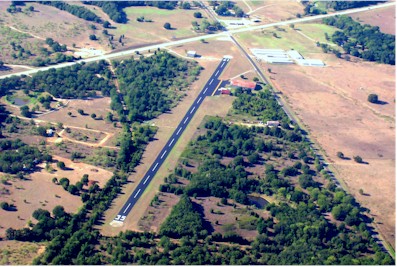
| Facility Name: | H H COFFIELD RGNL |
| City Name: | ROCKDALE |
| County: | MILAM |
| State abbrev: | TX |
| State Name: | TEXAS |
| | |
| Ownership: | PUBLICLY OWNED |
| Use: | OPEN TO THE PUBLIC |
| Owner's Name: | CITY OF ROCKDALE |
| Address: | 505 W. CAMERON |
| | ROCKDALE, TX 76567 |
| Owner's Phone: | 512-446-2511 |
| | |
| Manager's Name: | JERALD BRUNSON; DIRECTOR OF PUBLIC WORKS/AMGR |
| Address: | 505 W. CAMERON |
| | ROCKDALE, TX 76567 |
| Phone: | (512) 760-6991 |
| | |
| FAA Region: | SOUTHWEST |
| FAA Field Office: | TEX |
Runway Identifications
Runway Identification: 17/35Length: 2962 ft
Width: 50 ft
Surface: ASPHALT-FAIR CONDITION
Edge lights: Non-Standard Lighting SystemTreatment: NONE
| | Runway: 17 | | Runway: 35 |
| Mag heading: | N/A | Mag heading: | N/A |
| Rwy Slope: | -.68% Down | Rwy Slope: | .68% Up |
| Approach: | | Approach: | |
| Pattern: | Left Traffic | Pattern: | Left Traffic |
| Markings: | NONSTANDARD | Markings: | NONSTANDARD |
| Marking Condition: | FAIR | Marking Condition: | FAIR |
| Arresting Dev: | | Arresting Dev: | |
| Lat & Long: | N3038.1 W09659.4 | Lat. & Long.: | N3037.6 W09659.4 |
| Elev: | 474.0 ft. MSL | Elev: | 453.8 ft. MSL |
| TCH: | | TCH: | |
| Visual Glide Path: | | Visual Glide Path: | |
| Displaced Threshold: | No | Displaced Threshold: | No |
| Touchdown Zone: | NO | Touchdown Zone: | NO |
| Touchdown Elev.: | | Touchdown Elev.: | |
| Visual Glide Slope: | | Visual Glide Slope: | |
| RVR Equipment: | | RVR Equipment: | |
| RVV Equipment: | NO | RVV Equipment: | NO |
| Approach Lights: | | Approach Lights: | |
| REIL: | NO | REIL: | NO |
| Centerline Lights: | NO | Centerline Lights: | NO |
| Touchdown lights: | NO | Touchdown lights: | NO |
| Runway Category: | Runway with a Visual Approach | Runway Category: | Runway with a Visual Approach |
| Declared Distances: | | Declared Distances: | |
| Obstructions: | ROAD | Obstructions: | TREES |
| Marked: | NOT Marked/Lighted | Marked: | NOT Marked/Lighted |
| Clearance slope: | APCH SLOPE IS GTR THAN 45 DEG ANGLE. | Clearance slope: | |
| Obstruction height: | 17 feet AGL | Obstruction height: | 45 feet AGL |
| Dist. from runway: | 201 feet | Dist. from runway: | 201 feet |
| Centerline offset: | 80 left of centerline | Centerline offset: | 112 feet left of centerline |
| Comments: | 4 FT FENCE, 0-199 FT DSTC, 125-50 FT L. | Comments: | 50 FT TREES, 0-199 FT DSTC, 112 FT L. |