Current Weather/Notams (Metars, TAFs, Notams, NWS Forecast, PIREPS, and nearby weather)
Customs Information Send updates to Support@FltPlan.com
Customs Not Available
Database effective 05/16/2024
Airport Diagram might not be current.
|
| Facility Name: | CLARENCE E PAGE MUNI |
| City Name: | OKLAHOMA CITY |
| County: | CANADIAN |
| State abbrev: | OK |
| State Name: | OKLAHOMA |
| | |
| Ownership: | PUBLICLY OWNED |
| Use: | OPEN TO THE PUBLIC |
| Owner's Name: | CITY OF OKLAHOMA CITY |
| Address: | 7100 TERMINAL DR., BOX 937 |
| | OKLAHOMA CITY, OK 73159 |
| Owner's Phone: | (405) 316-3200 |
| | |
| Manager's Name: | KRISTY SLATER |
| Address: | 5915 PHILLIP J. RHOADES RM 104 |
| | BETHANY, OK 73008 |
| Phone: | 405-316-4061 |
| | |
| FAA Region: | SOUTHWEST |
| FAA Field Office: | AOK |
Runway Identifications
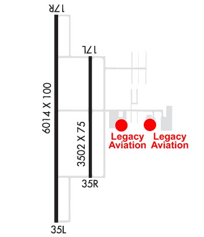
Runway Identification: 17L/35RLength: 3502 ft
Width: 75 ft
Surface: CONCRETE-GOOD CONDITION
Edge lights: Medium IntensityTreatment: NONE
| | Runway: 17L | | Runway: 35R |
| Mag heading: | 173° | Mag heading: | 353° |
| Rwy Slope: | -.11% Down | Rwy Slope: | .11% Up |
| Approach: | | Approach: | |
| Pattern: | Left Traffic | Pattern: | Right Traffic |
| Markings: | BASIC | Markings: | BASIC |
| Marking Condition: | GOOD | Marking Condition: | GOOD |
| Arresting Dev: | | Arresting Dev: | |
| Lat & Long: | N3529.6 W09749.3 | Lat. & Long.: | N3529.0 W09749.3 |
| Elev: | 1343.0 ft. MSL | Elev: | 1339.0 ft. MSL |
| TCH: | | TCH: | |
| Visual Glide Path: | | Visual Glide Path: | |
| Displaced Threshold: | No | Displaced Threshold: | No |
| Touchdown Zone: | YES | Touchdown Zone: | YES |
| Touchdown Elev.: | 1353.8 feet | Touchdown Elev.: | 1353.8 feet |
| Visual Glide Slope: | | Visual Glide Slope: | |
| RVR Equipment: | | RVR Equipment: | |
| RVV Equipment: | NO | RVV Equipment: | NO |
| Approach Lights: | | Approach Lights: | |
| REIL: | NO | REIL: | NO |
| Centerline Lights: | NO | Centerline Lights: | NO |
| Touchdown lights: | NO | Touchdown lights: | NO |
| Runway Category: | Runway with a Visual Approach | Runway Category: | Runway with a Visual Approach |
| Declared Distances: | | Declared Distances: | |
Runway Identification: 17R/35LLength: 6014 ft
Width: 100 ft
Surface: CONCRETE-GOOD CONDITION
Edge lights: High IntensityTreatment: NONE
| | Runway: 17R | | Runway: 35L |
| Mag heading: | 173° | Mag heading: | 353° |
| Rwy Slope: | -.14% Down | Rwy Slope: | .14% Up |
| Approach: | | Approach: | |
| Pattern: | Right Traffic | Pattern: | Left Traffic |
| Markings: | NONPRECISION INSTRUMENT | Markings: | NONPRECISION INSTRUMENT |
| Marking Condition: | GOOD | Marking Condition: | GOOD |
| Arresting Dev: | | Arresting Dev: | |
| Lat & Long: | N3529.8 W09749.5 | Lat. & Long.: | N3528.8 W09749.5 |
| Elev: | 1350.5 ft. MSL | Elev: | 1342.3 ft. MSL |
| TCH: | 52 ft. AGL | TCH: | 41 ft. AGL |
| Visual Glide Path: | 3.00 degrees | Visual Glide Path: | 3.00 degrees |
| Displaced Threshold: | No | Displaced Threshold: | No |
| Touchdown Zone: | YES | Touchdown Zone: | YES |
| Touchdown Elev.: | 1350.8 feet | Touchdown Elev.: | 1350.0 feet |
| Visual Glide Slope: | 4-Light PAPI on LEFT side of Runway | Visual Glide Slope: | 4-Light PAPI on LEFT side of Runway |
| RVR Equipment: | | RVR Equipment: | |
| RVV Equipment: | NO | RVV Equipment: | NO |
| Approach Lights: | | Approach Lights: | |
| REIL: | NO | REIL: | NO |
| Centerline Lights: | NO | Centerline Lights: | NO |
| Touchdown lights: | NO | Touchdown lights: | NO |
| Runway Category: | Runway with a Non-precision Approach having visibility minimums greater than 3/4 mile | Runway Category: | Runway with a Non-precision Approach having visibility minimums greater than 3/4 mile |
| Declared Distances: | | Declared Distances: | |
| Obstructions: | FENCE | Obstructions: | TREES |
| Marked: | LIGHTED | Marked: | NOT Marked/Lighted |
| Clearance slope: | 7:1 | Clearance slope: | 25:1 |
| Obstruction height: | 7 feet AGL | Obstruction height: | 26 feet AGL |
| Dist. from runway: | 250 feet | Dist. from runway: | 850 feet |
| Centerline offset: | 220 right of centerline | Centerline offset: | 330 feet right of centerline |
| Comments: | | Comments: | |