Current Weather/Notams (Metars, TAFs, Notams, NWS Forecast, PIREPS, and nearby weather)
Customs Information Send updates to Support@FltPlan.com
Customs Not Available
Database effective 04/18/2024
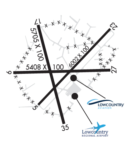
Airport Diagram might not be current. Facility Name: LOWCOUNTRY RGNL City Name: WALTERBORO County: COLLETON State abbrev: SC State Name: SOUTH CAROLINA Ownership: PUBLICLY OWNED Use: OPEN TO THE PUBLIC Owner's Name: CITY OF WALTERBORO AND COLLETON CO. Address: 537 AVIATION WAY WALTERBORO, SC 29488 Owner's Phone: 843-549-2549 Manager's Name: BERT DUFFIE Address: 537 AVIATION WAY WALTERBORO, SC 29488 Phone: 843-955-0290 FAA Region: SOUTHERN FAA Field Office: ATL
Runway Identifications Help
Runway Identification: 05/23 Length: 6002 ftWidth: 100 ftSurface: CONCRETE ASPHALT-GOOD CONDITIONEdge lights: Medium Intensity Treatment: NONEWeight: PCN 26 /F/B/X/T Runway: 05 Runway: 23 Mag heading: 49° Mag heading: 229° Rwy Slope: .19% Up Rwy Slope: -.19% Down Approach: Approach: ILS/DME Pattern: Left Traffic Pattern: Left Traffic Markings: NONPRECISION INSTRUMENT Markings: PRECISION INSTRUMENT Marking Condition: GOOD Marking Condition: GOOD Arresting Dev: Arresting Dev: Lat & Long: N3254.9 W08038.7 Lat. & Long.: N3255.7 W08037.9 Elev: 89.4 ft. MSL Elev: 100.9 ft. MSL TCH: 49 ft. AGL TCH: 46 ft. AGL Visual Glide Path: 3.50 degrees Visual Glide Path: 3.00 degrees Displaced Threshold: No Displaced Threshold: No Touchdown Zone: YES Touchdown Zone: YES Touchdown Elev.: 96.4 feet Touchdown Elev.: 100.9 feet Visual Glide Slope: 2-Light PAPI on LEFT side of Runway Visual Glide Slope: 2-Light PAPI on LEFT side of Runway RVR Equipment: RVR Equipment: RVV Equipment: NO RVV Equipment: NO Approach Lights: Approach Lights: ODALS - omnidirectional approach lighting system REIL: NO REIL: YES Centerline Lights: NO Centerline Lights: NO Touchdown lights: NO Touchdown lights: NO Runway Category: Runway with a Non-precision Approach having visibility minimums greater than 3/4 mile Runway Category: Precision Instrument Runway Declared Distances: Declared Distances: Obstructions: TREES Obstructions: TREES Marked: NOT Marked/Lighted Marked: NOT Marked/Lighted Clearance slope: 21:1 Clearance slope: 28:1 Obstruction height: 82 feet AGL Obstruction height: 83 feet AGL Dist. from runway: 1999 feet Dist. from runway: 2527 feet Centerline offset: 265 right of centerline Centerline offset: 823 feet left of centerline Comments: Comments:
Runway Identification: 09/27 Length: 5408 ftWidth: 100 ftSurface: CONCRETE ASPHALTEdge lights: Treatment: NONE Runway: 09 Runway: 27 Mag heading: 94° Mag heading: 274° Rwy Slope: .21% Up Rwy Slope: -.21% Down Approach: Approach: Pattern: Left Traffic Pattern: Left Traffic Markings: BASIC Markings: BASIC Marking Condition: POOR Marking Condition: POOR Arresting Dev: Arresting Dev: Lat & Long: N3255.2 W08039.0 Lat. & Long.: N3255.3 W08037.9 Elev: 80.9 ft. MSL Elev: 92.2 ft. MSL TCH: TCH: Visual Glide Path: Visual Glide Path: Displaced Threshold: No Displaced Threshold: No Touchdown Zone: YES Touchdown Zone: YES Touchdown Elev.: 95.7 feet Touchdown Elev.: 96.0 feet Visual Glide Slope: Visual Glide Slope: RVR Equipment: RVR Equipment: RVV Equipment: NO RVV Equipment: NO Approach Lights: Approach Lights: REIL: NO REIL: NO Centerline Lights: NO Centerline Lights: NO Touchdown lights: NO Touchdown lights: NO Runway Category: Runway with a Visual Approach Runway Category: Runway with a Visual Approach Declared Distances: Declared Distances: Obstructions: TREES Obstructions: Unknown Marked: NOT Marked/Lighted Marked: NOT Marked/Lighted Clearance slope: 8:1 Clearance slope: 28:1 Obstruction height: 52 feet AGL Obstruction height: 67 feet AGL Dist. from runway: 637 feet Dist. from runway: 2105 feet Centerline offset: 176 right of centerline Centerline offset: 251 feet left of centerline Comments: Comments:
Runway Identification: 17/35 Length: 5705 ftWidth: 100 ftSurface: CONCRETE ASPHALTEdge lights: Treatment: NONEWeight: PCN 10 /F/B/X/T Runway: 17 Runway: 35 Mag heading: 171° Mag heading: 351° Rwy Slope: .16% Up Rwy Slope: -.16% Down Approach: Approach: Pattern: Left Traffic Pattern: Left Traffic Markings: NONPRECISION INSTRUMENT Markings: NONPRECISION INSTRUMENT Marking Condition: GOOD Marking Condition: GOOD Arresting Dev: Arresting Dev: Lat & Long: N3255.7 W08038.7 Lat. & Long.: N3254.8 W08038.4 Elev: 82.3 ft. MSL Elev: 91.6 ft. MSL TCH: TCH: Visual Glide Path: Visual Glide Path: Displaced Threshold: No Displaced Threshold: No Touchdown Zone: YES Touchdown Zone: YES Touchdown Elev.: 92.5 feet Touchdown Elev.: 95.2 feet Visual Glide Slope: Visual Glide Slope: RVR Equipment: RVR Equipment: RVV Equipment: NO RVV Equipment: NO Approach Lights: Approach Lights: REIL: NO REIL: NO Centerline Lights: NO Centerline Lights: NO Touchdown lights: NO Touchdown lights: NO Runway Category: Runway with a Non-precision Approach having visibility minimums greater than 3/4 mile Runway Category: Runway with a Non-precision Approach having visibility minimums greater than 3/4 mile Declared Distances: Declared Distances: Obstructions: TREE Obstructions: TREE Marked: NOT Marked/Lighted Marked: NOT Marked/Lighted Clearance slope: 1:1 Clearance slope: 38:1 Obstruction height: 17 feet AGL Obstruction height: 57 feet AGL Dist. from runway: 233 feet Dist. from runway: 2370 feet Centerline offset: 74 left of centerline Centerline offset: 43 feet left of centerline Comments: Comments: