Current Weather/Notams (Metars, TAFs, Notams, NWS Forecast, PIREPS, and nearby weather)
Customs Information Send updates to Support@FltPlan.com
Customs Not Available
Database effective 05/16/2024
Airport Diagram might not be current. Facility Name: DALLAS EXEC City Name: DALLAS County: DALLAS State abbrev: TX State Name: TEXAS Ownership: PUBLICLY OWNED Use: OPEN TO THE PUBLIC Owner's Name: CITY OF DALLAS Address: 1500 MARILLA DALLAS, TX 75201 Owner's Phone: 214-670-7612 Manager's Name: RAFAEL GARZA JR. Address: 5303 CHALLENGER DR. DALLAS, TX 75237 Phone: 214-670-7612 FAA Region: SOUTHWEST FAA Field Office: TEX
Runway Identifications Help
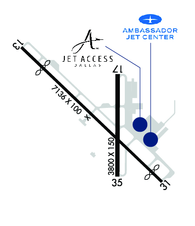
Runway Identification: 13/31 Length: 7136 ftWidth: 100 ftSurface: CONCRETEEdge lights: Medium Intensity Treatment: GROOVED Runway: 13 Runway: 31 Mag heading: 129° Mag heading: 309° Rwy Slope: -.09% Down Rwy Slope: .09% Up Approach: Approach: ILS/DME Pattern: Left Traffic Pattern: Left Traffic Markings: NONPRECISION INSTRUMENT Markings: PRECISION INSTRUMENT Marking Condition: GOOD Marking Condition: GOOD Arresting Dev: Arresting Dev: Lat & Long: N3241.3 W09652.7 Lat. & Long.: N3240.5 W09651.7 Elev: 653.4 ft. MSL Elev: 646.9 ft. MSL TCH: 40 ft. AGL TCH: 45 ft. AGL Visual Glide Path: 3.00 degrees Visual Glide Path: 3.00 degrees Displaced Threshold: 1085 feet Displaced Threshold: 500 feet Touchdown Zone: YES Touchdown Zone: YES Touchdown Elev.: 657.3 feet Touchdown Elev.: 659.8 feet Visual Glide Slope: 4-Light PAPI on LEFT side of Runway Visual Glide Slope: 4-Light PAPI on RIGHT side of Runway RVR Equipment: RVR Equipment: RVV Equipment: NO RVV Equipment: NO Approach Lights: Approach Lights: REIL: YES REIL: YES Centerline Lights: NO Centerline Lights: NO Touchdown lights: NO Touchdown lights: NO Runway Category: Runway with a Visual Approach Runway Category: Precision Instrument Runway Declared Distances: TORA:6766' TODA:7136' ASDA:6622' LDA:5537' Declared Distances: TORA:6051' TODA:7136' ASDA:7101' LDA:6601' Obstructions: TREES Obstructions: ROAD Marked: NOT Marked/Lighted Marked: NOT Marked/Lighted Clearance slope: APCH SLOPE 0:1 TO DSPLCD THLD OVR 20 FT TREES, 0 FT DSTC, 395 FT R. Clearance slope: 49:1 Obstruction height: 25 feet AGL Obstruction height: 7 feet AGL Dist. from runway: 201 feet Dist. from runway: 547 feet Centerline offset: 380 right of centerline Centerline offset: 513 feet right of centerline Comments: 25 FT TREES, 0-199 FT DSTC, 380 FT R, 413 FT L. Comments:
Runway Identification: 17/35 Length: 3800 ftWidth: 150 ftSurface: CONCRETE-GOOD CONDITIONEdge lights: Medium Intensity Treatment: NONE Runway: 17 Runway: 35 Mag heading: 174° Mag heading: 354° Rwy Slope: .23% Up Rwy Slope: -.23% Down Approach: Approach: Pattern: Left Traffic Pattern: Left Traffic Markings: NONPRECISION INSTRUMENT Markings: NONPRECISION INSTRUMENT Marking Condition: GOOD Marking Condition: GOOD Arresting Dev: Arresting Dev: Lat & Long: N3241.1 W09652.0 Lat. & Long.: N3240.5 W09652.0 Elev: 650.6 ft. MSL Elev: 659.2 ft. MSL TCH: 43 ft. AGL TCH: Visual Glide Path: 3.00 degrees Visual Glide Path: Displaced Threshold: No Displaced Threshold: No Touchdown Zone: YES Touchdown Zone: YES Touchdown Elev.: 657.9 feet Touchdown Elev.: 659.2 feet Visual Glide Slope: 4-Light PAPI on RIGHT side of Runway Visual Glide Slope: RVR Equipment: RVR Equipment: RVV Equipment: NO RVV Equipment: NO Approach Lights: Approach Lights: REIL: YES REIL: YES Centerline Lights: NO Centerline Lights: NO Touchdown lights: NO Touchdown lights: NO Runway Category: Runway with a Non-precision Approach having visibility minimums greater than 3/4 mile Runway Category: Runway with a Non-precision Approach having visibility minimums greater than 3/4 mile Declared Distances: Declared Distances: