Click here for more info on on SMS!

KRAS

MUSTANG BEACH
PORT ARANSAS
TX
Time Zone: Central
Lat: N 2748.7
Long: W 09705.3
Elev: 5
Var: -05
Longest Runway: 3482
AWOS: 118.42
CTAF: 122.9

FBO & Flight Services info for KRAS

FBOs: Update your Fuel Prices

PORT ARANSAS APPh: 361-749-4008
-
Freq: 122.9
Service
Jet
100LL
SAF
MoGas
Full        Caution: Fuel prices have not been updated in 50 days.
Last Update: 03/01/2024 12:15

Self  5.35    
 Address: 130 PIPER BLVD,   PORT ARANSAS, TX 78373
AWOSPh: 361-749-0537
-
Freq: 118.42  
If you are an FBO, call 1-203-262-1700 to update your info or email: FltPlan.Advertising@garmin.com
Advertise your FBO on FltPlan.com

Runway & Approach Info for KRAS
Rwy
Length
Land Dist**
Approach*
  Rwy
Length
Land Dist**
Approach*
12
3482x70  3482'          
 
  
30
  3482x70  3482'          
 
 * only ILS, LOC, LDA, and SDF approaches to a specific runway are shown
** For any Declared Landing Distance Available, please see A/FD or Approach plates
Runway Weight Capability (lbs.) Help
Runway IDSingle WheelDouble WheelDouble Tandem WheelDual Double Wheel
12/30N/AN/AN/AN/A
These numbers are Advisory and are not limits.   The Airport Manager should have more accurate Weight Limits
Approach Charts
Approaches    
Current Weather/Notams
Customs Information Send updates to Support@FltPlan.com
Customs Not Available
Database effective 04/18/2024
Airport Diagram of KRAS
Airport Diagram might not be current.
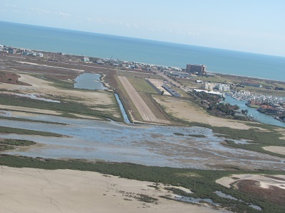
Facility Name: MUSTANG BEACH
City Name: PORT ARANSAS
County: NUECES
State abbrev: TX
State Name: TEXAS
   
Ownership: PUBLICLY OWNED
Use: OPEN TO THE PUBLIC
Owner's Name: CITY OF PORT ARANSAS
Address: 710 W. AVE A
 PORT ARANSAS, TX 78373-4128
Owner's Phone: 361-749-4111
  
Manager's Name: DAVID PARSONS
Address: 710 W. AVE A
 PORT ARANSAS, TX 78373-4128
Phone: 361-749-4008
   
FAA Region: SOUTHWEST
FAA Field Office: TEX
Photo courtesy of Jim Wilson, January 2017.


Click here for full scale & interactive Sectional view of KRAS


Sunrise / Sunset times for MUSTANG BEACH

DateSunriseSunset
04/19/24 Friday6:5919:56
04/20/24 Saturday6:5819:57
04/21/24 Sunday6:5719:57
04/22/24 Monday6:5619:58
04/23/24 Tuesday6:5519:58
04/24/24 Wednesday6:5419:59
04/25/24 Thursday6:5320:00
04/26/24 Friday6:5220:00
04/27/24 Saturday6:5120:01
04/28/24 Sunday6:5120:01
04/29/24 Monday6:5020:02
04/30/24 Tuesday6:4920:02
05/01/24 Wednesday6:4820:03
05/02/24 Thursday6:4720:04

Airport Facilities

Airport Attendance ScheduleIRREGULAR
Airport Status OPERATIONAL (This Status can change at any time - please check NOTAMS)
Airport Lighting ScheduleSS-SR
Airport Storage AvailableTie Downs
Extra Services AvailableParachute Jumping
Wind IndicatorYES - (lighted)
Control TowerNO
CTAF Frequency122.900
Unicom Frequency
Rotating Beacon ColorWG
Segmented CircleYES
Landing FeeNO; OVERNIGHT TIEDOWN FEE.

Airport Inspection Data

Airport InspectedSTATE - performed by PRIVATE CONTRACT PERSONNEL
Inspection Date04/18/2023

Airport Services

Type of Fuel AvailableGrade 100LL; -10FUEL 24 HR SELF SERV.
Airframe Repair ServiceNone
Power Plant Repair ServiceNone

Geographic Data

LatitudeN2748.7
LongitudeW09705.3 (ESTIMATED)
Arpt Elevation5ft (SURVEYED)
Magnetic Variation05E
2 miles SWof PORT ARANSAS
Traffic Pattern Altitude
Sectional ChartBROWNSVILLE

Aircraft Data

Operations (Reported)YearlyAvg. Daily
General Aviation Transient 30008
General Aviation Local 3241
Air Taxi 00
Commerical 00
Commuter 00
Military 00
Aircraft based on Field
General Aviation Singles 9
General Aviation Multi 1
Jet Aircraft 0
General Aviation Helicopters 0
Military Aircraft 0
Gliders 0
Ultralights 0

FAA Services

FSS on field NO
FSS tie-in SAN ANGELO
FSS Phone 1-800-WX-BRIEF
Who issues Notams RAS
Notam D service at airport YES
ARTCC Name HOUSTON

Federal Status

Airport Certification
Aircraft Rescue & Firefighting IndexNone
Airport of EntryNo
Custom Landing RightsNo
Joint Civil/MilitaryNo
Military Landing rightsNo

Remarks

RY 12 HAS A -3 FT DROP OFF NEAR END OF RY; RY 30 HAS A 3 FT DITCH 180 FT FM END OF RY.
RY 30 29 FT POWER LINE 1133 FT FM THLD L AND R OF CNTRLN. 48 FT POWER LINE 1791 FT FM THLD L AND R OF CNTRLN.
FOR CD CTC CORPUS CHRISTI APCH AT 361-299-4230.
RWY 12/3 0 RWY SFC SEAL-PEASTONES. CONSIDERABEL AMT OF LOOSE STONES ON RWY & TWY.
Airport Communications & Frequencies:
CTAF Frequency:
122.900
CORPUS Primary Approach Frequencies:  
125.4
307.9
CORPUS Primary Departure Frequencies:  
125.4
307.9
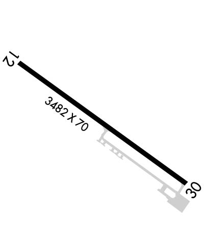
Runway Identifications
Runway Identification: 12/30
Length: 3482 ft
Width: 70 ft
Surface: ASPHALT-POOR CONDITION
Edge lights: Medium Intensity

Treatment: NONE

 Runway: 12   Runway: 30
Mag heading: 120°Mag heading: 300°
Rwy Slope: .00% UpRwy Slope: .00% Down
Approach: Approach:
Pattern: Left TrafficPattern: Left Traffic
Markings: NONPRECISION INSTRUMENTMarkings: NONPRECISION INSTRUMENT
Marking Condition: FAIRMarking Condition: FAIR
Arresting Dev: Arresting Dev:
Lat & Long: N2748.9  W09705.6Lat. & Long.: N2748.5  W09705.1
Elev: 4.4 ft. MSLElev: 4.5 ft. MSL
TCH: 20 ft. AGLTCH: 22 ft. AGL
Visual Glide Path: 3.00 degreesVisual Glide Path: 3.20 degrees
Displaced Threshold: NoDisplaced Threshold: No
Touchdown Zone: YESTouchdown Zone: YES
Touchdown Elev.: 5.0 feetTouchdown Elev.: 5.0 feet
Visual Glide Slope: 2-Light PAPI on LEFT side of RunwayVisual Glide Slope: 2-Light PAPI on LEFT side of Runway
RVR Equipment: RVR Equipment:
RVV Equipment: NORVV Equipment: NO
Approach Lights: Approach Lights:
REIL: NOREIL: NO
Centerline Lights: NOCenterline Lights: NO
Touchdown lights: NOTouchdown lights: NO
Runway Category: Runway with a Non-precision ApproachRunway Category: Runway with a Non-precision Approach
Declared Distances: Declared Distances:
Obstructions: Obstructions: TREE
Marked: Marked: NOT Marked/Lighted
Clearance slope: 50:1Clearance slope:
Obstruction height: Obstruction height: 22 feet AGL
Dist. from runway: Dist. from runway: 200 feet
Centerline offset: Centerline offset: 244 feet left of centerline
Comments: Comments: 3 FT SIGN AND PARKED ACFT 0 FT - 190 FT AT 189 FT L, 8 FT DIRT MOUND 85 FT - 256 FT FM THLD AT 125 FT L.
C:9/P: