Click here for more info on on SMS!

KRAP

RAPID CITY RGNL
RAPID CITY
SD
Time Zone: Mountain
Lat: N 4402.7
Long: W 10303.4
Elev: 3204
Var: -08
Longest Runway: 8701
AWOS: 118.52
Ground: 121.9
Tower: 125.85

FBO & Flight Services info for KRAP

FBOs: Update your Fuel Prices
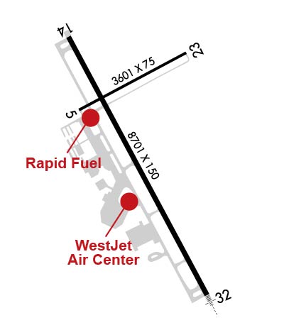
Westjet Air Center, Inc. is a full service Fixed Based Operator (FBO), located at the edge of the breathtaking Black Hills of South Dakota, which is the home of historic Mount Rushmore. We are open 24 hours daily, offering highly trained personnel and aircraft equipment to serve all your air transportation needs.
Ph: 605-393-2500 Fax: 605-393-1631 Freq: 122.95WebsiteE-Mail
                     
Service
Jet
100LL
SAF
MoGas
Fuel Avail: 24/7
Full6.496.69    Last Update: 04/09/2024 08:23

Self        
Misc. Info: Address: 4160 FIRE STATION RD-REG ARP,   RAPID CITY, SD 57703
We offer self-service fuel, aircraft maintenance, and avionics.

- For Rapid Fuel, call 605-209-5466
- For Avionics and Maintenance, 605-393-0000

Lowest Fuel Prices on the Field!
Ph: 605-209-5466
-
-
--
Service
Jet
100LL
SAF
MoGas
Fuel Avail: SELF SERVICE 100LL & Jet A, sold only!! JET A INCLUDES PRIST. 24/7.
Full        Last Update: 04/20/2024 16:39

Self4.995.99    
Misc. Info: Jet A 100 ft hoses for single point & over-the-wing connectionsAddress: 3900 AIRPORT RD   RAPID CITY, SD 57703

ASOSPh: 605-393-2832
-
Freq: 118.52  
If you are an FBO, call 1-203-262-1700 to update your info or email: FltPlan.Advertising@garmin.com
Advertise your FBO on FltPlan.com

Runway & Approach Info for KRAP
Rwy
Length
Land Dist**
Approach*
  Rwy
Length
Land Dist**
Approach*
05
3601x75  3601'          
 
  
23
  3601x75  3601'          
 
14
8701x150  8701'          
 
  
32
  8701x150  8701'          
ILS/DME
 109.30 - 323°  
 * only ILS, LOC, LDA, and SDF approaches to a specific runway are shown
** For any Declared Landing Distance Available, please see A/FD or Approach plates
Runway Weight Capability (lbs.) Help
Runway IDSingle WheelDouble WheelDouble Tandem WheelDual Double Wheel
05/2312,500N/AN/AN/A
14/32140,000190,000300,000N/A
These numbers are Advisory and are not limits.   The Airport Manager should have more accurate Weight Limits
Approach Charts
Approaches    
Current Weather/Notams
Customs Information Send updates to Support@FltPlan.com
Customs Not Available
Database effective 05/16/2024
Airport Diagram of KRAP
Airport Diagram might not be current.

Facility Name: RAPID CITY RGNL
City Name: RAPID CITY
County: PENNINGTON
State abbrev: SD
State Name: SOUTH DAKOTA
   
Ownership: PUBLICLY OWNED
Use: OPEN TO THE PUBLIC
Owner's Name: CITY OF RAPID CITY
Address: 4550 TERMINAL RD - STE 102
 RAPID CITY, SD 57703
Owner's Phone: 605-394-4195
  
Manager's Name: PATRICK DAME
Address: 4550 TERMINAL RD - STE 102
 RAPID CITY, SD 57703
Phone: 605-394-4195
   
FAA Region: GREAT LAKES
FAA Field Office: DMA


Sunrise / Sunset times for RAPID CITY RGNL

DateSunriseSunset
04/24/24 Wednesday5:5319:48
04/25/24 Thursday5:5119:49
04/26/24 Friday5:5019:51
04/27/24 Saturday5:4819:52
04/28/24 Sunday5:4719:53
04/29/24 Monday5:4519:54
04/30/24 Tuesday5:4419:55
05/01/24 Wednesday5:4319:57
05/02/24 Thursday5:4119:58
05/03/24 Friday5:4019:59
05/04/24 Saturday5:3820:00
05/05/24 Sunday5:3720:01
05/06/24 Monday5:3620:02
05/07/24 Tuesday5:3420:04

Airport Facilities

Airport Attendance ScheduleCONTINUOUS
Airport Status OPERATIONAL (This Status can change at any time - please check NOTAMS)
Airport Lighting ScheduleWHEN ATCT CLSD ACTVT MALSR RWY 32; REIL RWY 14; HIRL RWY 14/32; MIRL RWY 05/23; TWY A & B LGTS - CTAF. PAPI RWYS 05, 14, 23, 32 OPR CONSLY.
Airport Storage AvailableTie Downs, Hanger
Extra Services AvailableAir Freight, Air Ambulance, Avionics, Charter, Flight Instruction, Aircraft Rental, Aircraft Sales, Annual Surveying
Wind IndicatorYES - (lighted)
Control TowerYES
CTAF Frequency125.850
Unicom Frequency122.950
Rotating Beacon ColorWG
Segmented CircleYES
Landing FeeYES; LNDG FEES RQRD FOR AIRCRAFT 12,500 LBS OR GTR.

Airport Inspection Data

Airport InspectedFEDERAL - performed by FAA AIRPORTS FIELD PERSONNEL
Inspection Date10/18/2023

Airport Services

Type of Fuel AvailableGrade 100LL, JET A (freeze point -40C); -A 100LL & JETA SELF SVC AVBL 24 HRS WITH CREDIT CARD ONLY NE SIDE OF GA RAMP.
Airframe Repair ServiceMAJOR
Power Plant Repair ServiceMAJOR

Geographic Data

LatitudeN4402.7
LongitudeW10303.4 (ESTIMATED)
Arpt Elevation3203ft (SURVEYED)
Magnetic Variation08E
8 miles SEof RAPID CITY
Traffic Pattern Altitude
Sectional ChartCHEYENNE

Aircraft Data

Operations (Reported)YearlyAvg. Daily
General Aviation Transient 1649145
General Aviation Local 1099230
Air Taxi 656018
Commerical 775421
Commuter 00
Military 20086
Aircraft based on Field
General Aviation Singles 61
General Aviation Multi 12
Jet Aircraft 3
General Aviation Helicopters 2
Military Aircraft 0
Gliders 0
Ultralights 0

FAA Services

FSS on field NO
FSS tie-in HURON
FSS Phone 1-800-WX-BRIEF
Who issues Notams RAP
Notam D service at airport YES
ARTCC Name DENVER

Federal Status

Airport CertificationAIRPORT RECEIVING SCHEDULED AIR CARRIER SERVICE FROM CARRIERS CERTIFICATED BY THE CIVIL AERONAUTICS BOARD; ARFF INDEX C AVBL UPON REQ.
Aircraft Rescue & Firefighting IndexAIRPORT HAS A CERTIFICATE UNDER CFR PART 139
Airport of EntryNo
Custom Landing RightsNo
Joint Civil/MilitaryNo
Military Landing rightsYES

Federal Agreements

NATIONAL PLAN OF INTEGRATED AIRPORT SYSTEMS (NPIAS)
GRANT AGREEMENTS UNDER FAAP/ADAP/AIP
ASSURANCES PURSUANT TO TITLE VI, CIVIL RIGHTS ACT OF 1964

Remarks

BIRDS ON & INVOF ARPT.
TWR HAS LIMITED VISIBILITY OF TWY T1 AND TWY T2 AND TWY B AT AER RWY 23
USE OF ARMY NATIONAL GUARD (ANG) RAMP IS OFFICIAL BUSINESS ONLY; FOR PPR CALL ANG FLIGHT OPS AT (605) 737-6128. NORMAL ANG OPS ARE TUES-FRI 1400-0030Z++ EXCEPT HOLIDAYS.
OVERNIGHT PARKING ALLOWED IN DESIGNATED TIEDOWN AREAS ONLY.
CTC GROUND FOR FREE TIE-DOWN LOCATIONS, OR CALL ARPT OPNS AT 605-593-3419.
ALL CHARTER SERVICED ACFT OVER 12,500 LBS MUST CTC ARPT OPNS AT 605-593-3419 AT LEAST 48 HOURS PRIOR TO ARRIVAL.
DIVERTING NON-BASED AIR CARRIERS CTC ARPT OPS AT (605) 593-3419 PRIOR TO DIVERTING DUE TO LIMITED GATE SPACE. NO CUSTOMS SERVICE AVBL.
FOR CD CTC GND OR ATCT ON FREQ. IF UNA, CTC RAP ATCT AT 605-393-1161. WHEN ATCT CLSD, CTC ELLSWORTH APCH AT 605-385-6198. WHEN APCH CLSD CTC DENVER ARTCC AT 303-651-4257.
RWY 5/23 NOT AVBL TO ACFT OVER 12500 LBS TO TAXI.
HIGH VOL OF HELI TOURS INVOF MT RUSHMORE AND CRAZY HORSE MONUMENTS AT OR BLW 7500 FT; ALL OTR ACFT SHOULD RMN AT OR ABOVE 7700 FT AND MAINTAIN 1 NM HORIZONTAL SEPARATION FROM THE MONUMENTS; PILOTS ARE ADVISED TO MONITOR 122.85 FOR TFC ADVISORIES.
BE ALERT: EXTENSIVE MILITARY JET TFC INVOF & NNW OF ARPT.
LINE-OF-SIGHT IS RESTRICTED BETWEEN RY 14 & RY 23 PHYSICAL ENDS.
152 FT AGL TWR 2.5 NM NNW OF ARPT.
BE ALERT DO NOT MISTAKE ELLSWORTH AFB, LOCATED 6.5 NM NNW FOR RAPID CITY RGNL.
RWY 05/2 3 RWY 5/23 NOT AVBL FOR SKEDD ACR OPNS WITH MORE THAN 9 PSGR SEATS OR UNSKED ACR AT LEAST 31 PSGR SEATS.
Airport Communications & Frequencies:
RAPID CITY Tower Frequencies:   Hours(local) of operation: 0600-2200   
125.85
257.8
RAPID CITY Ground Frequencies:
121.9
Emergency Frequencies:
121.5
243.0
CTAF Frequency:
125.850
Unicom Frequency:
122.950
Remarks
  • APCH/DEP CTL SVC PRVDD BY DENVER ARTCC (ZDV) ON FREQS 127.95/338.2 (RAPID CITY RCAG) WHEN ELLSWORTH APCH CTL (RCA) CLSD.
  • ELLSWORTH Primary Approach Frequencies:  
    119.5
    259.1
    ELLSWORTH Primary Departure Frequencies:  
    119.5
    289.4
    Runway Identifications
    Runway Identification: 05/23
    Length: 3601 ft
    Width: 75 ft
    Surface: ASPHALT-GOOD CONDITION
    Edge lights: Medium Intensity

    Treatment: NONE
    Weight: PCN 15 /F/C/X/T

     Runway: 05   Runway: 23
    Mag heading: 54°Mag heading: 234°
    Rwy Slope: .85% UpRwy Slope: -.85% Down
    Approach: Approach:
    Pattern: Right TrafficPattern: Left Traffic
    Markings: NONPRECISION INSTRUMENTMarkings: NONPRECISION INSTRUMENT
    Marking Condition: FAIRMarking Condition: FAIR
    Arresting Dev: Arresting Dev:
    Lat & Long: N4402.9  W10303.8Lat. & Long.: N4403.2  W10303.1
    Elev: 3173.0 ft. MSLElev: 3203.5 ft. MSL
    TCH: 34 ft. AGLTCH: 38 ft. AGL
    Visual Glide Path: 3.00 degreesVisual Glide Path: 3.00 degrees
    Displaced Threshold: NoDisplaced Threshold: No
    Touchdown Zone: YESTouchdown Zone: YES
    Touchdown Elev.: 3199.4 feetTouchdown Elev.: 3203.5 feet
    Visual Glide Slope: 2-Light PAPI on LEFT side of RunwayVisual Glide Slope: 2-Light PAPI on LEFT side of Runway
    RVR Equipment: RVR Equipment:
    RVV Equipment: NORVV Equipment: NO
    Approach Lights: Approach Lights:
    REIL: NOREIL: NO
    Centerline Lights: NOCenterline Lights: NO
    Touchdown lights: NOTouchdown lights: NO
    Runway Category: Runway with a Non-precision ApproachRunway Category: Runway with a Non-precision Approach
    Declared Distances: TORA:3601' TODA:3601' ASDA:3601' LDA:3601'Declared Distances: TORA:3601' TODA:3601' ASDA:3601' LDA:3601'
    Obstructions: Obstructions: ROAD
    Marked: Marked: NOT Marked/Lighted
    Clearance slope: 50:1Clearance slope: 28:1
    Obstruction height: Obstruction height: 15 feet AGL
    Dist. from runway: Dist. from runway: 628 feet
    Centerline offset: Centerline offset:
    Comments: Comments:
    Runway Identification: 14/32
    Length: 8701 ft
    Width: 150 ft
    Surface: CONCRETE-GOOD CONDITION
    Edge lights: High Intensity

    Treatment: GROOVED
    Weight: PCN 65 /R/C/W/T

     Runway: 14   Runway: 32
    Mag heading: 144°Mag heading: 324°
    Rwy Slope: -.56% DownRwy Slope: .56% Up
    Approach: Approach: ILS/DME
    Pattern: Left TrafficPattern: Left Traffic
    Markings: PRECISION INSTRUMENTMarkings: PRECISION INSTRUMENT
    Marking Condition: GOODMarking Condition: GOOD
    Arresting Dev: Arresting Dev:
    Lat & Long: N4403.2  W10303.9Lat. & Long.: N4402.0  W10303.0
    Elev: 3191.2 ft. MSLElev: 3142.8 ft. MSL
    TCH: 50 ft. AGLTCH: 54 ft. AGL
    Visual Glide Path: 3.00 degreesVisual Glide Path: 3.00 degrees
    Displaced Threshold: NoDisplaced Threshold: No
    Touchdown Zone: YESTouchdown Zone: YES
    Touchdown Elev.: 3191.2 feetTouchdown Elev.: 3159.8 feet
    Visual Glide Slope: 4-Light PAPI on LEFT side of RunwayVisual Glide Slope: 4-Light PAPI on LEFT side of Runway
    RVR Equipment: ROLLOUTRVR Equipment: TOUCHDOWN
    RVV Equipment: NORVV Equipment: NO
    Approach Lights: Approach Lights: MALSR - 1,400 foot medium intensity approach lighting system with runway alignment indicator lights
    REIL: YESREIL: NO
    Centerline Lights: NOCenterline Lights: NO
    Touchdown lights: NOTouchdown lights: NO
    Runway Category: DRunway Category: Precision Instrument Runway
    Declared Distances: TORA:8701' TODA:8701' ASDA:8701' LDA:8701'Declared Distances: TORA:8701' TODA:8701' ASDA:8701' LDA:8701'
    Obstructions: FENCEObstructions:
    Marked: NOT Marked/LightedMarked:
    Clearance slope: 32:1Clearance slope: 50:1
    Obstruction height: 25 feet AGLObstruction height:
    Dist. from runway: 1000 feetDist. from runway:
    Centerline offset: 435 left of centerlineCenterline offset:
    Comments: Comments:
    C:110/P: