Current Weather/Notams (Metars, TAFs, Notams, NWS Forecast, PIREPS, and nearby weather)
Customs Information Send updates to Support@FltPlan.com
Phone 262-633-0286Fax 262-633-4054Comments 2 hr advance notice required. Business hrs 0800-1630 Monday-Friday. *Maximum passengers per flight: 15 *M-F Call prior to 1730 on preceding weekday. *WKND Call prior to 1730 on preceding Friday
Database effective 05/16/2024
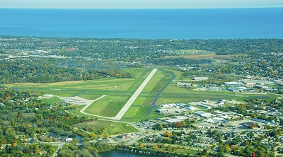
Airport Diagram might not be current. Facility Name: BATTEN INTL City Name: RACINE County: RACINE State abbrev: WI State Name: WISCONSIN Ownership: PRIVATELY OWNED Use: OPEN TO THE PUBLIC Owner's Name: RACINE COMMERCIAL APRT CORP. Address: 3239 N. GREEN BAY RD RACINE, WI 53404 Owner's Phone: 262-631-5620 Manager's Name: TAMARA SANDBERG Address: 3239 N. GREEN BAY RD RACINE, WI 53404 Phone: 262-631-5620 FAA Region: GREAT LAKES FAA Field Office: CHI
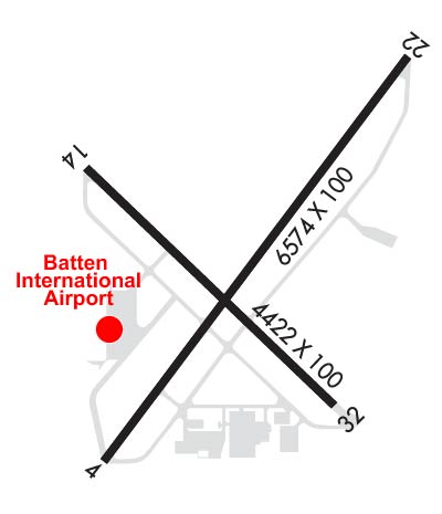
Runway Identifications Help
Runway Identification: 04/22 Length: 6574 ftWidth: 100 ftSurface: CONCRETE-GOOD CONDITIONEdge lights: High Intensity Treatment: GROOVEDWeight: PCN 18 /R/B/W/T Runway: 04 Runway: 22 Mag heading: 39° Mag heading: 219° Rwy Slope: -.11% Down Rwy Slope: .11% Up Approach: ILS Approach: Pattern: Left Traffic Pattern: Left Traffic Markings: PRECISION INSTRUMENT Markings: PRECISION INSTRUMENT Marking Condition: GOOD Marking Condition: GOOD Arresting Dev: Arresting Dev: Lat & Long: N4245.3 W08749.2 Lat. & Long.: N4246.1 W08748.3 Elev: 672.4 ft. MSL Elev: 665.0 ft. MSL TCH: 45 ft. AGL TCH: 46 ft. AGL Visual Glide Path: 3.00 degrees Visual Glide Path: 3.00 degrees Displaced Threshold: 734 feet Displaced Threshold: 390 feet Touchdown Zone: YES Touchdown Zone: YES Touchdown Elev.: 667.7 feet Touchdown Elev.: 666.3 feet Visual Glide Slope: 4-Light PAPI on LEFT side of Runway Visual Glide Slope: 4-Light PAPI on LEFT side of Runway RVR Equipment: RVR Equipment: RVV Equipment: NO RVV Equipment: NO Approach Lights: MALSF - 1,400 foot medium intensity approach lighting system with sequenced flashers Approach Lights: REIL: NO REIL: YES Centerline Lights: NO Centerline Lights: NO Touchdown lights: NO Touchdown lights: NO Runway Category: Precision Instrument Runway Runway Category: Runway with a Non-precision Approach having visibility minimums greater than 3/4 mile Declared Distances: Declared Distances: Obstructions: ROAD Obstructions: RR Marked: NOT Marked/Lighted Marked: NOT Marked/Lighted Clearance slope: APCH RATIO 38:1 TO DSPLCD THR; 29 FT TREE 1100 FT FM DSPLCD THR; 350 FT R. Clearance slope: APCH RATIO 21:1 TO DSPLCD THR; 29 FT TREE 615 FT FM DSPCLD THR; 65 FT R. Obstruction height: 6 feet AGL Obstruction height: 8 feet AGL Dist. from runway: 200 feet Dist. from runway: 200 feet Centerline offset: 140 right of centerline Centerline offset: 50 feet left of centerline Comments: 10 FT FENCE 40 TO 80 FT FM RWY END BOTH SIDES OF CNTRLN; 15 FT RD 0 TO 200 FT FM RWY END BOTH SIDES OF CNTRLN. Comments: 60 FT RR 0 TO 200 FT FM RWY END; 60 TO 230 FT L; 20 FT TREE 10 FT FM RWY END; 130 FT L.
Runway Identification: 14/32 Length: 4421 ftWidth: 100 ftSurface: ASPHALT-FAIR CONDITIONEdge lights: Medium Intensity Treatment: NONE Runway: 14 Runway: 32 Mag heading: 135° Mag heading: 315° Rwy Slope: -.35% Down Rwy Slope: .35% Up Approach: Approach: Pattern: Left Traffic Pattern: Left Traffic Markings: NONPRECISION INSTRUMENT Markings: NONPRECISION INSTRUMENT Marking Condition: GOOD Marking Condition: GOOD Arresting Dev: Arresting Dev: Lat & Long: N4245.9 W08749.3 Lat. & Long.: N4245.4 W08748.6 Elev: 673.6 ft. MSL Elev: 658.2 ft. MSL TCH: 55 ft. AGL TCH: Visual Glide Path: 4.00 degrees Visual Glide Path: Displaced Threshold: 807 feet Displaced Threshold: No Touchdown Zone: YES Touchdown Zone: YES Touchdown Elev.: 669.9 feet Touchdown Elev.: 666.6 feet Visual Glide Slope: 4-Light PAPI on LEFT side of Runway Visual Glide Slope: RVR Equipment: RVR Equipment: RVV Equipment: NO RVV Equipment: NO Approach Lights: Approach Lights: REIL: YES REIL: YES Centerline Lights: NO Centerline Lights: NO Touchdown lights: NO Touchdown lights: NO Runway Category: Runway with a Visual Approach Runway Category: Runway with a Non-precision Approach having visibility minimums greater than 3/4 mile Declared Distances: Declared Distances: Obstructions: ROAD Obstructions: TREE Marked: NOT Marked/Lighted Marked: NOT Marked/Lighted Clearance slope: APCH RATIO 16:1 TO DSPLCD THLD; 58 FT TREE 900 FT FM DSPLCD THR; 150 FT R. Clearance slope: 18:1 Obstruction height: 15 feet AGL Obstruction height: 31 feet AGL Dist. from runway: 200 feet Dist. from runway: 770 feet Centerline offset: Centerline offset: 100 feet left of centerline Comments: 10 FT FENCE 0 TO 200 FT FM RWY END BOTH SIDES OF CNTRLN; 15 FT RD 0 TO 200 FT FM RWY END BOTH SIDES OF CNTRLN; 58 FT TREE 80 FT FM RWY END; 175 FT R. Comments: