
| ||||||||||||||||||||||||||||||||||||||||||||
| ||||||||||||||||||||||||||||||||||||||||||||
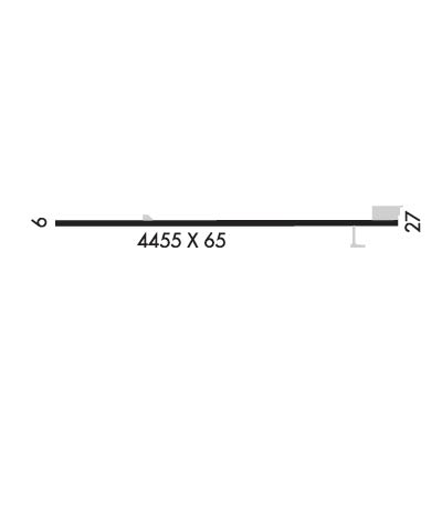
| Rwy | Rwy | |||||||
| 4455x65 | 4455' | 4455x65 | 4455' | |||||
| Runway ID | Single Wheel | Double Wheel | Double Tandem Wheel | Dual Double Wheel |
| 09/27 | N/A | N/A | N/A | N/A |
| These numbers are Advisory and are not limits. The Airport Manager should have more accurate Weight Limits | ||||
| FltPlan does not have IFR approach charts available for KR47. |
 Airport Diagram might not be current. | |
| Facility Name: | RUHES |
| City Name: | LEIPSIC |
| County: | PUTNAM |
| State abbrev: | OH |
| State Name: | OHIO |
| Ownership: | PRIVATELY OWNED |
| Use: | OPEN TO THE PUBLIC |
| Owner's Name: | BOB RUHE AGRICULTURE SERVICE |
| Address: | 5450 STATE ROUTE 109 |
| LEIPSIC, OH 45856-9438 | |
| Owner's Phone: | 419-943-3352; FAX 419-943-3971. |
| Manager's Name: | MARILYN RUHE |
| Address: | 5450 STATE ROUTE 109 |
| LEIPSIC, OH 45856-9438 | |
| Phone: | 419-943-3352 |
| FAA Region: | GREAT LAKES |
| FAA Field Office: | DET |
| Date | Sunrise | Sunset |
|---|---|---|
| 04/15/24 Monday | 6:56 | 20:17 |
| 04/16/24 Tuesday | 6:54 | 20:18 |
| 04/17/24 Wednesday | 6:53 | 20:19 |
| 04/18/24 Thursday | 6:51 | 20:20 |
| 04/19/24 Friday | 6:50 | 20:21 |
| 04/20/24 Saturday | 6:48 | 20:22 |
| 04/21/24 Sunday | 6:47 | 20:23 |
| 04/22/24 Monday | 6:45 | 20:24 |
| 04/23/24 Tuesday | 6:44 | 20:26 |
| 04/24/24 Wednesday | 6:42 | 20:27 |
| 04/25/24 Thursday | 6:41 | 20:28 |
| 04/26/24 Friday | 6:40 | 20:29 |
| 04/27/24 Saturday | 6:38 | 20:30 |
| 04/28/24 Sunday | 6:37 | 20:31 |
| Airport Attendance Schedule | MON-SAT 0700-1700, SUN PRIOR ARNGMT |
| Airport Status | OPERATIONAL (This Status can change at any time - please check NOTAMS) |
| Airport Lighting Schedule | ACTVT NSTD LIRL RWY 09/27 - CALL AMGR. |
| Airport Storage Available | Tie Downs, Hanger |
| Extra Services Available | Crop Dusting |
| Wind Indicator | YES - (unlit) |
| Control Tower | NO |
| CTAF Frequency | 123.000 |
| Unicom Frequency | 123.000 |
| Rotating Beacon Color | |
| Segmented Circle | NO |
| Landing Fee |
| Airport Inspected | STATE - performed by STATE AERONAUTICAL PERSONNEL |
| Inspection Date | 06/13/2023 |
| Type of Fuel Available | None |
| Airframe Repair Service | MINOR |
| Power Plant Repair Service | MINOR |
| Latitude | N4106.2 |
| Longitude | W08403.1 (ESTIMATED) |
| Arpt Elevation | 801ft (ESTIMATED) |
| Magnetic Variation | 04W |
| 3 miles W | of LEIPSIC |
| Traffic Pattern Altitude | |
| Sectional Chart | DETROIT |
| Operations (Reported) | Yearly | Avg. Daily |
|---|---|---|
| General Aviation Transient | 24 | 0 |
| General Aviation Local | 5000 | 14 |
| Air Taxi | 0 | 0 |
| Commerical | 0 | 0 |
| Commuter | 0 | 0 |
| Military | 0 | 0 |
| Aircraft based on Field | |
|---|---|
| General Aviation Singles | 7 |
| General Aviation Multi | 0 |
| Jet Aircraft | 0 |
| General Aviation Helicopters | 0 |
| Military Aircraft | 0 |
| Gliders | 0 |
| Ultralights | 0 |
| FSS on field | NO |
| FSS tie-in | CLEVELAND |
| FSS Phone | 1-800-WX-BRIEF |
| Who issues Notams | CLE |
| Notam D service at airport | YES |
| ARTCC Name | CLEVELAND |
| Airport Certification | |
| Aircraft Rescue & Firefighting Index | None |
| Airport of Entry | No |
| Custom Landing Rights | No |
| Joint Civil/Military | No |
| Military Landing rights | No |
| EXTSV CROP DUSTING OPS WITH NO TFC PAT; MOST TKOFS TO W & LDGS TO E. |
| FOR CD CTC TOLEDO APCH AT 419-865-1495. |
| RWY 09/2 7 EAST 2500 X 30 FT FAIR; RMNG POOR DUE TO RAVELING & LOOSE STONES. |
| RWY 09/2 7 NSTD LIRL DUE TO 360 DEG GREEN THR LGTS; SOUTH EDGE LGTS 20 FT FM RWY EDGE. |
| RWY 09 1 NSTD BASIC DUE TO MISG RWY NRS & SML CNTRLN. |
| RWY 27 1 NSTD BASIC DUE TO MISG RWY NRS & SML CNTRLN. |
| Runway: 09 | Runway: 27 | ||
| Mag heading: | N/A | Mag heading: | N/A |
| Approach: | Approach: | ||
| Pattern: | Left Traffic | Pattern: | Left Traffic |
| Markings: | NONSTANDARD | Markings: | NONSTANDARD |
| Marking Condition: | POOR; FADED. | Marking Condition: | POOR; FADED. |
| Arresting Dev: | Arresting Dev: | ||
| Lat & Long: | Lat. & Long.: | ||
| Elev: | N/A | Elev: | N/A |
| TCH: | TCH: | ||
| Visual Glide Path: | Visual Glide Path: | ||
| Displaced Threshold: | No | Displaced Threshold: | No |
| Touchdown Zone: | NO | Touchdown Zone: | NO |
| Touchdown Elev.: | Touchdown Elev.: | ||
| Visual Glide Slope: | Visual Glide Slope: | ||
| RVR Equipment: | RVR Equipment: | ||
| RVV Equipment: | NO | RVV Equipment: | NO |
| Approach Lights: | Approach Lights: | ||
| REIL: | NO | REIL: | NO |
| Centerline Lights: | NO | Centerline Lights: | NO |
| Touchdown lights: | NO | Touchdown lights: | NO |
| Runway Category: | Runway with a Visual Approach | Runway Category: | Runway with a Visual Approach |
| Declared Distances: | Declared Distances: | ||
| Obstructions: | Obstructions: | ANT | |
| Marked: | Marked: | NOT Marked/Lighted | |
| Clearance slope: | 20:1 | Clearance slope: | 5:1 |
| Obstruction height: | Obstruction height: | 38 feet AGL | |
| Dist. from runway: | Dist. from runway: | 400 feet | |
| Centerline offset: | Centerline offset: | 115 feet right of centerline | |
| Comments: | Comments: |
