Current Weather/Notams (Metars, TAFs, Notams, NWS Forecast, PIREPS, and nearby weather)
Customs Information Send updates to Support@FltPlan.com
Customs Not Available
Database effective 05/16/2024
Airport Diagram might not be current. Facility Name: MC GREGOR EXEC City Name: WACO County: MC LENNAN State abbrev: TX State Name: TEXAS Ownership: PUBLICLY OWNED Use: OPEN TO THE PUBLIC Owner's Name: CITY OF MCGREGOR Address: P O BOX 192 MC GREGOR, TX 76657 Owner's Phone: 254-840-2806 Manager's Name: BARRY LIGHTFOOT Address: PO BOX 192 MC GREGOR, TX 76657 Phone: 254-848-5477; OR 254-848-2345. (FBO) 254-840-2855 (POLICE) FAA Region: SOUTHWEST FAA Field Office: TEX
Runway Identifications Help
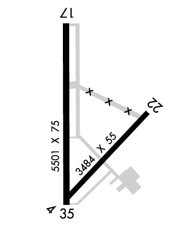
Runway Identification: 04/22 Length: 3484 ftWidth: 55 ftSurface: ASPHALT-GOOD CONDITIONEdge lights: Treatment: NONE Runway: 04 Runway: 22 Mag heading: 38° Mag heading: 218° Rwy Slope: .01% Up Rwy Slope: -.01% Down Approach: Approach: Pattern: Left Traffic Pattern: Left Traffic Markings: BASIC Markings: BASIC Marking Condition: GOOD Marking Condition: GOOD Arresting Dev: Arresting Dev: Lat & Long: N3128.8 W09719.1 Lat. & Long.: N3129.2 W09718.6 Elev: 567.6 ft. MSL Elev: 568.0 ft. MSL TCH: TCH: Visual Glide Path: Visual Glide Path: Displaced Threshold: No Displaced Threshold: No Touchdown Zone: YES Touchdown Zone: YES Touchdown Elev.: 571.0 feet Touchdown Elev.: 571.0 feet Visual Glide Slope: Visual Glide Slope: RVR Equipment: RVR Equipment: RVV Equipment: NO RVV Equipment: NO Approach Lights: Approach Lights: REIL: NO REIL: NO Centerline Lights: NO Centerline Lights: NO Touchdown lights: NO Touchdown lights: NO Runway Category: Runway with a Visual Approach Runway Category: Runway with a Visual Approach Declared Distances: Declared Distances: Obstructions: TREES Obstructions: Marked: NOT Marked/Lighted Marked: Clearance slope: 33:1 Clearance slope: 50:1 Obstruction height: 74 feet AGL Obstruction height: Dist. from runway: 2690 feet Dist. from runway: Centerline offset: Centerline offset: Comments: Comments:
Runway Identification: 17/35 Length: 5501 ftWidth: 75 ftSurface: ASPHALT-GOOD CONDITIONEdge lights: Medium Intensity Treatment: NONE Runway: 17 Runway: 35 Mag heading: 173° Mag heading: 353° Rwy Slope: -.45% Down Rwy Slope: .45% Up Approach: Approach: Pattern: Left Traffic Pattern: Left Traffic Markings: NONPRECISION INSTRUMENT Markings: NONPRECISION INSTRUMENT Marking Condition: GOOD Marking Condition: GOOD Arresting Dev: Arresting Dev: Lat & Long: N3129.6 W09719.1 Lat. & Long.: N3128.7 W09719.1 Elev: 590.5 ft. MSL Elev: 566.0 ft. MSL TCH: 36 ft. AGL TCH: 46 ft. AGL Visual Glide Path: 3.00 degrees Visual Glide Path: 3.00 degrees Displaced Threshold: No Displaced Threshold: No Touchdown Zone: YES Touchdown Zone: YES Touchdown Elev.: 591.7 feet Touchdown Elev.: 580.4 feet Visual Glide Slope: 4-Light PAPI on LEFT side of Runway Visual Glide Slope: 4-Light PAPI on LEFT side of Runway RVR Equipment: RVR Equipment: RVV Equipment: NO RVV Equipment: NO Approach Lights: Approach Lights: REIL: YES REIL: NO Centerline Lights: NO Centerline Lights: NO Touchdown lights: NO Touchdown lights: NO Runway Category: D Runway Category: D Declared Distances: Declared Distances: Obstructions: TREES Obstructions: TREES Marked: NOT Marked/Lighted Marked: NOT Marked/Lighted Clearance slope: 28:1 Clearance slope: 25:1 Obstruction height: 32 feet AGL Obstruction height: 39 feet AGL Dist. from runway: 1112 feet Dist. from runway: 1200 feet Centerline offset: Centerline offset: Comments: Comments: