
| ||||||||||||||||||||||||||||||||||||||||||||
| ||||||||||||||||||||||||||||||||||||||||||||
| ||||||||||||||||||||||||||||||||||||||||||||
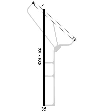
| Rwy | Rwy | |||||||
| 5001x100 | 5001' | 5001x100 | 5001' | |||||
| Runway ID | Single Wheel | Double Wheel | Double Tandem Wheel | Dual Double Wheel |
| 17/35 | 42,000 | 55,000 | 110,000 | N/A |
| These numbers are Advisory and are not limits. The Airport Manager should have more accurate Weight Limits | ||||
 Airport Diagram might not be current. | |
| Facility Name: | PAULS VALLEY MUNI |
| City Name: | PAULS VALLEY |
| County: | GARVIN |
| State abbrev: | OK |
| State Name: | OKLAHOMA |
| Ownership: | PUBLICLY OWNED |
| Use: | OPEN TO THE PUBLIC |
| Owner's Name: | CITY OF PAULS VALLEY |
| Address: | CITY HALL, PO BOX 778, PO BOX 961 |
| PAULS VALLEY, OK 73075 | |
| Owner's Phone: | (405) 238-3308 |
| Manager's Name: | CRAIG CARSON |
| Address: | 500 AIRPORT RD. |
| PAULS VALLEY, OK 73075 | |
| Phone: | 405-238-7338; 405-207-6619. |
| FAA Region: | SOUTHWEST |
| FAA Field Office: | AOK |
| Date | Sunrise | Sunset |
|---|---|---|
| 04/18/24 Thursday | 6:53 | 20:04 |
| 04/19/24 Friday | 6:51 | 20:05 |
| 04/20/24 Saturday | 6:50 | 20:06 |
| 04/21/24 Sunday | 6:49 | 20:07 |
| 04/22/24 Monday | 6:48 | 20:07 |
| 04/23/24 Tuesday | 6:47 | 20:08 |
| 04/24/24 Wednesday | 6:45 | 20:09 |
| 04/25/24 Thursday | 6:44 | 20:10 |
| 04/26/24 Friday | 6:43 | 20:11 |
| 04/27/24 Saturday | 6:42 | 20:11 |
| 04/28/24 Sunday | 6:41 | 20:12 |
| 04/29/24 Monday | 6:40 | 20:13 |
| 04/30/24 Tuesday | 6:39 | 20:14 |
| 05/01/24 Wednesday | 6:38 | 20:15 |
| Airport Attendance Schedule | MON-FRI 0800-1700 |
| Airport Status | OPERATIONAL (This Status can change at any time - please check NOTAMS) |
| Airport Lighting Schedule | ACTVT REIL RWY 17 & 35; PAPI RWY 17 & 35; MIRL RWY 17/35 - CTAF. |
| Airport Storage Available | Tie Downs |
| Extra Services Available | Crop Dusting, Flight Instruction, Aircraft Rental |
| Wind Indicator | YES - (lighted) |
| Control Tower | NO |
| CTAF Frequency | 122.800 |
| Unicom Frequency | 122.800 |
| Rotating Beacon Color | WG |
| Segmented Circle | YES |
| Landing Fee | NO |
| Airport Inspected | STATE - performed by STATE AERONAUTICAL PERSONNEL |
| Inspection Date | 03/03/2022 |
| Type of Fuel Available | Grade 100LL, JET A (freeze point -40C); -A ON REQUEST.; -10AVBL H24 WITH CREDIT CARD. |
| Airframe Repair Service | MAJOR |
| Power Plant Repair Service | MAJOR |
| Latitude | N3442.6 |
| Longitude | W09713.4 (ESTIMATED) |
| Arpt Elevation | 970ft (SURVEYED) |
| Magnetic Variation | 06E |
| 2 miles S | of PAULS VALLEY |
| Traffic Pattern Altitude | |
| Sectional Chart | DALLAS-FT WORTH |
| Operations (Reported) | Yearly | Avg. Daily |
|---|---|---|
| General Aviation Transient | 3350 | 9 |
| General Aviation Local | 3350 | 9 |
| Air Taxi | 0 | 0 |
| Commerical | 0 | 0 |
| Commuter | 0 | 0 |
| Military | 600 | 2 |
| Aircraft based on Field | |
|---|---|
| General Aviation Singles | 30 |
| General Aviation Multi | 3 |
| Jet Aircraft | 3 |
| General Aviation Helicopters | 1 |
| Military Aircraft | 0 |
| Gliders | 0 |
| Ultralights | 0 |
| FSS on field | NO |
| FSS tie-in | MC ALESTER |
| FSS Phone | 1-800-WX-BRIEF |
| Who issues Notams | PVJ |
| Notam D service at airport | YES |
| ARTCC Name | FORT WORTH |
| Airport Certification | |
| Aircraft Rescue & Firefighting Index | None |
| Airport of Entry | No |
| Custom Landing Rights | No |
| Joint Civil/Military | No |
| Military Landing rights | YES |
| NATIONAL PLAN OF INTEGRATED AIRPORT SYSTEMS (NPIAS) |
| SURPLUS PROPERTY AGREEMENT UNDER REGULATION 16-WAA |
| GRANT AGREEMENT HAS EXPIRED; HOWEVER, AGREEMENT REMAINS IN EFFECT FOR THIS FACILITY AS LONG AS IT IS PUBLIC USE. |
| AGREEMENT UNDER DLAND OR DCLA HAS EXPIRED. |
| ULTRALIGHTS ON & INVOF ARPT. |
| FOR CD CTC FORT WORTH ARTCC AT 817-858-7584. |
Airport Communications & Frequencies:
| |||||||||
| Runway: 17 | Runway: 35 | ||
| Mag heading: | 174° | Mag heading: | 354° |
| Rwy Slope: | -.46% Down | Rwy Slope: | .46% Up |
| Approach: | Approach: | ||
| Pattern: | Left Traffic | Pattern: | Left Traffic |
| Markings: | NONPRECISION INSTRUMENT | Markings: | NONPRECISION INSTRUMENT |
| Marking Condition: | GOOD | Marking Condition: | GOOD |
| Arresting Dev: | Arresting Dev: | ||
| Lat & Long: | N3442.9 W09713.4 | Lat. & Long.: | N3442.0 W09713.5 |
| Elev: | 970.8 ft. MSL | Elev: | 947.9 ft. MSL |
| TCH: | 45 ft. AGL | TCH: | 45 ft. AGL |
| Visual Glide Path: | 3.00 degrees | Visual Glide Path: | 3.00 degrees |
| Displaced Threshold: | No | Displaced Threshold: | No |
| Touchdown Zone: | YES | Touchdown Zone: | YES |
| Touchdown Elev.: | 970.8 feet | Touchdown Elev.: | 955.5 feet |
| Visual Glide Slope: | 4-Light PAPI on LEFT side of Runway | Visual Glide Slope: | 4-Light PAPI on LEFT side of Runway |
| RVR Equipment: | RVR Equipment: | ||
| RVV Equipment: | NO | RVV Equipment: | NO |
| Approach Lights: | Approach Lights: | ||
| REIL: | YES | REIL: | YES |
| Centerline Lights: | NO | Centerline Lights: | NO |
| Touchdown lights: | NO | Touchdown lights: | NO |
| Runway Category: | Runway with a Non-precision Approach having visibility minimums greater than 3/4 mile | Runway Category: | D |
| Declared Distances: | Declared Distances: | ||
| Obstructions: | TREES | Obstructions: | |
| Marked: | NOT Marked/Lighted | Marked: | |
| Clearance slope: | 21:1 | Clearance slope: | 34:1 |
| Obstruction height: | 38 feet AGL | Obstruction height: | |
| Dist. from runway: | 1035 feet | Dist. from runway: | |
| Centerline offset: | 75 left of centerline | Centerline offset: | |
| Comments: | Comments: |
