
| ||||||||||||||||||||||||||||||||||||||||||||||||||||||||||||||||||||
| ||||||||||||||||||||||||||||||||||||||||||||||||||||||||||||||||||||
| ||||||||||||||||||||||||||||||||||||||||||||||||||||||||||||||||||||
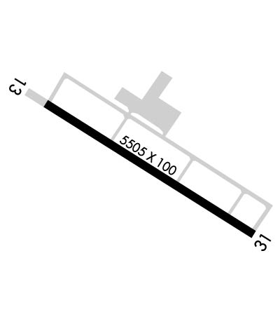
| Rwy | Rwy | |||||||
| 5505x100 | 5505' | 5505x100 | 5505' | 109.15 - 311° | ||||
| Runway ID | Single Wheel | Double Wheel | Double Tandem Wheel | Dual Double Wheel |
| 13/31 | 90,000 | 130,000 | N/A | N/A |
| These numbers are Advisory and are not limits. The Airport Manager should have more accurate Weight Limits | ||||
 Airport Diagram might not be current. | |
| Facility Name: | PAULDING NORTHWEST ATLANTA |
| City Name: | ATLANTA |
| County: | PAULDING |
| State abbrev: | GA |
| State Name: | GEORGIA |
| Ownership: | PUBLICLY OWNED |
| Use: | OPEN TO THE PUBLIC |
| Owner's Name: | PAULDING CO BOARD OF COMMISSIONERS; AND PAULDING COUNTY AIRPORT AUTHORITY |
| Address: | 240 CONSTITUTION BLVD; PCAA ADDRESS - 730 AIRPORT PARKWAY, DALLAS, GA 30157 |
| DALLAS, GA 30132 | |
| Owner's Phone: | 770-443-7550; PCAA PHONE - 770-505-7700 |
| Manager's Name: | TERRY TIBBITTS |
| Address: | 730 AIRPORT PARKWAY, SUITE 100 |
| DALLAS, GA 30157 | |
| Phone: | 770-505-7700 |
| FAA Region: | SOUTHERN |
| FAA Field Office: | ATL |
| Date | Sunrise | Sunset |
|---|---|---|
| 04/24/24 Wednesday | 6:57 | 20:19 |
| 04/25/24 Thursday | 6:56 | 20:19 |
| 04/26/24 Friday | 6:55 | 20:20 |
| 04/27/24 Saturday | 6:54 | 20:21 |
| 04/28/24 Sunday | 6:53 | 20:22 |
| 04/29/24 Monday | 6:52 | 20:22 |
| 04/30/24 Tuesday | 6:51 | 20:23 |
| 05/01/24 Wednesday | 6:50 | 20:24 |
| 05/02/24 Thursday | 6:49 | 20:25 |
| 05/03/24 Friday | 6:48 | 20:26 |
| 05/04/24 Saturday | 6:47 | 20:26 |
| 05/05/24 Sunday | 6:46 | 20:27 |
| 05/06/24 Monday | 6:45 | 20:28 |
| 05/07/24 Tuesday | 6:44 | 20:29 |
| Airport Attendance Schedule | SAT-SUN 0900-1700, MON-FRI 0730-1800 |
| Airport Status | OPERATIONAL (This Status can change at any time - please check NOTAMS) |
| Airport Lighting Schedule | ACTVT REIL RWY 13 & 31; PAPI RWY 13 & 31; HIRL RWY 13/31; TWY LGTS - CTAF. |
| Airport Storage Available | Tie Downs |
| Extra Services Available | Flight Instruction, Aircraft Rental |
| Wind Indicator | YES - (lighted) |
| Control Tower | NO |
| CTAF Frequency | 123.075 |
| Unicom Frequency | 123.075 |
| Rotating Beacon Color | WG |
| Segmented Circle | YES |
| Landing Fee |
| Airport Inspected | STATE - performed by STATE AERONAUTICAL PERSONNEL |
| Inspection Date | 03/21/2024 |
| Type of Fuel Available | Grade 100LL, JET A |
| Airframe Repair Service | MAJOR |
| Power Plant Repair Service | MAJOR |
| Latitude | N3354.7 |
| Longitude | W08456.4 (ESTIMATED) |
| Arpt Elevation | 1289ft (SURVEYED) |
| Magnetic Variation | 04W |
| 33 miles W | of ATLANTA |
| Traffic Pattern Altitude | |
| Sectional Chart | ATLANTA |
| Operations (Reported) | Yearly | Avg. Daily |
|---|---|---|
| General Aviation Transient | 16673 | 46 |
| General Aviation Local | 28836 | 79 |
| Air Taxi | 0 | 0 |
| Commerical | 0 | 0 |
| Commuter | 0 | 0 |
| Military | 1000 | 3 |
| Aircraft based on Field | |
|---|---|
| General Aviation Singles | 35 |
| General Aviation Multi | 4 |
| Jet Aircraft | 1 |
| General Aviation Helicopters | 0 |
| Military Aircraft | 0 |
| Gliders | 0 |
| Ultralights | 0 |
| FSS on field | NO |
| FSS tie-in | MACON |
| FSS Phone | 1-800-WX-BRIEF |
| Who issues Notams | MCN |
| Notam D service at airport | YES |
| ARTCC Name | ATLANTA |
| Airport Certification | |
| Aircraft Rescue & Firefighting Index | None |
| Airport of Entry | No |
| Custom Landing Rights | No |
| Joint Civil/Military | No |
| Military Landing rights | No |
| NATIONAL PLAN OF INTEGRATED AIRPORT SYSTEMS (NPIAS) |
| GRANT AGREEMENTS UNDER FAAP/ADAP/AIP |
| ASSURANCES PURSUANT TO TITLE VI, CIVIL RIGHTS ACT OF 1964 |
| FOR CD CTC ATLANTA APCH AT 678-364-6131. |
| WILDLIFE ON OR INVOF ARPT |
Airport Communications & Frequencies:
| ||||||||||||||
| Runway: 13 | Runway: 31 | ||
| Mag heading: | 131° | Mag heading: | 311° |
| Rwy Slope: | -.12% Down | Rwy Slope: | .12% Up |
| Approach: | Approach: | ILS/DME | |
| Pattern: | Left Traffic | Pattern: | Left Traffic |
| Markings: | PRECISION INSTRUMENT | Markings: | PRECISION INSTRUMENT |
| Marking Condition: | GOOD | Marking Condition: | GOOD |
| Arresting Dev: | Arresting Dev: | ||
| Lat & Long: | N3355.0 W08456.9 | Lat. & Long.: | N3354.4 W08456.0 |
| Elev: | 1289.0 ft. MSL | Elev: | 1282.3 ft. MSL |
| TCH: | 50 ft. AGL | TCH: | 49 ft. AGL |
| Visual Glide Path: | 3.00 degrees | Visual Glide Path: | 3.00 degrees |
| Displaced Threshold: | No | Displaced Threshold: | No |
| Touchdown Zone: | YES | Touchdown Zone: | YES |
| Touchdown Elev.: | 1289.0 feet | Touchdown Elev.: | 1283.3 feet |
| Visual Glide Slope: | 4-Light PAPI on LEFT side of Runway | Visual Glide Slope: | 4-Light PAPI on LEFT side of Runway |
| RVR Equipment: | RVR Equipment: | ||
| RVV Equipment: | NO | RVV Equipment: | NO |
| Approach Lights: | Approach Lights: | ||
| REIL: | YES | REIL: | YES |
| Centerline Lights: | NO | Centerline Lights: | NO |
| Touchdown lights: | NO | Touchdown lights: | NO |
| Runway Category: | D | Runway Category: | Precision Instrument Runway |
| Declared Distances: | Declared Distances: |


