Current Weather/Notams (Metars, TAFs, Notams, NWS Forecast, PIREPS, and nearby weather)
Customs Information Send updates to Support@FltPlan.com
Customs Not Available
Database effective 05/16/2024
Airport Diagram might not be current.
|
| Facility Name: | HERITAGE FLD |
| City Name: | POTTSTOWN |
| County: | MONTGOMERY |
| State abbrev: | PA |
| State Name: | PENNSYLVANIA |
| | |
| Ownership: | PRIVATELY OWNED |
| Use: | OPEN TO THE PUBLIC |
| Owner's Name: | LIMERICK AVIATION LP |
| Address: | 600 HORIZON DR |
| | CHALFONT, PA 18914 |
| Owner's Phone: | 215-997-8850 |
| | |
| Manager's Name: | CHRISTOPHER JORDAN |
| Address: | 3310 WEST RIDGE PIKE |
| | POTTSTOWN, PA 19464 |
| Phone: | (610) 495-7000 |
| | |
| FAA Region: | EASTERN |
| FAA Field Office: | HAR |
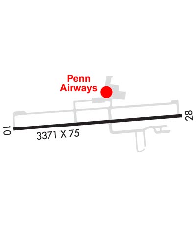
Runway Identifications
Runway Identification: 10/28Length: 3371 ft
Width: 75 ft
Surface: ASPHALT-GOOD CONDITION
Edge lights: Medium IntensityTreatment: NONE
| | Runway: 10 | | Runway: 28 |
| Mag heading: | 96° | Mag heading: | 276° |
| Rwy Slope: | -.13% Down | Rwy Slope: | .13% Up |
| Approach: | | Approach: | LOCALIZER |
| Pattern: | Left Traffic | Pattern: | Right Traffic |
| Markings: | NONPRECISION INSTRUMENT | Markings: | NONPRECISION INSTRUMENT |
| Marking Condition: | GOOD | Marking Condition: | GOOD |
| Arresting Dev: | | Arresting Dev: | |
| Lat & Long: | N4014.3 W07533.8 | Lat. & Long.: | N4014.4 W07533.0 |
| Elev: | 307.0 ft. MSL | Elev: | 302.6 ft. MSL |
| TCH: | 45 ft. AGL | TCH: | 45 ft. AGL |
| Visual Glide Path: | 3.00 degrees | Visual Glide Path: | 3.00 degrees |
| Displaced Threshold: | No | Displaced Threshold: | 190 feet |
| Touchdown Zone: | YES | Touchdown Zone: | YES |
| Touchdown Elev.: | 308.2 feet | Touchdown Elev.: | 308.2 feet |
| Visual Glide Slope: | 2-Light PAPI on LEFT side of Runway | Visual Glide Slope: | 2-Light PAPI on LEFT side of Runway |
| RVR Equipment: | | RVR Equipment: | |
| RVV Equipment: | NO | RVV Equipment: | NO |
| Approach Lights: | | Approach Lights: | |
| REIL: | YES | REIL: | YES |
| Centerline Lights: | NO | Centerline Lights: | NO |
| Touchdown lights: | NO | Touchdown lights: | NO |
| Runway Category: | Runway with a Non-precision Approach | Runway Category: | Runway with a Non-precision Approach |
| Declared Distances: | | Declared Distances: | |
| Obstructions: | TREES | Obstructions: | TREE |
| Marked: | NOT Marked/Lighted | Marked: | NOT Marked/Lighted |
| Clearance slope: | 17:1 | Clearance slope: | 8:1; RWY 28 APCH RATIO 16:1 TO DTHR. |
| Obstruction height: | 58 feet AGL | Obstruction height: | 48 feet AGL |
| Dist. from runway: | 1242 feet | Dist. from runway: | 585 feet |
| Centerline offset: | 175 left of centerline | Centerline offset: | 273 feet right of centerline |
| Comments: | | Comments: | 10 FT ROAD 0-200 FT FM THR. |


