Click here for more info on on SMS!

KPTV

PORTERVILLE MUNI
PORTERVILLE
CA
Time Zone: Pacific
Lat: N 3601.8
Long: W 11903.8
Elev: 443
Var: -15
Longest Runway: 5960
AWOS: 134.62
CTAF: 122.8

FBO & Flight Services info for KPTV

FBOs: Update your Fuel Prices

PORTERVILLE APPh: 559-782-7540 Fax: 559-788-2554 Freq: 122.8
Service
Jet
100LL
SAF
MoGas
Fuel Avail: PRIST+$0.10/gal.
Full5.806.05    Last Update: 03/27/2024 14:14

Self5.505.75    
 Address: 1893 S. NEWCOMB ST   PORTERVILLE, CA 93257
AWOSPh: 559-784-3874
-
Freq: 134.62  
If you are an FBO, call 1-203-262-1700 to update your info or email: FltPlan.Advertising@garmin.com
Advertise your FBO on FltPlan.com

Runway & Approach Info for KPTV
Rwy
Length
Land Dist**
Approach*
  Rwy
Length
Land Dist**
Approach*
12
5960x150  5960'          
 
  
30
  5960x150  5960'          
 
 * only ILS, LOC, LDA, and SDF approaches to a specific runway are shown
** For any Declared Landing Distance Available, please see A/FD or Approach plates
Runway Weight Capability (lbs.) Help
Runway IDSingle WheelDouble WheelDouble Tandem WheelDual Double Wheel
12/3030,00070,000110,000N/A
These numbers are Advisory and are not limits.   The Airport Manager should have more accurate Weight Limits
Approach Charts
Approaches    
Current Weather/Notams
Customs Information Send updates to Support@FltPlan.com
Customs Not Available
Database effective 04/18/2024
Airport Diagram of KPTV
Airport Diagram might not be current.

Facility Name: PORTERVILLE MUNI
City Name: PORTERVILLE
County: TULARE
State abbrev: CA
State Name: CALIFORNIA
   
Ownership: PUBLICLY OWNED
Use: OPEN TO THE PUBLIC
Owner's Name: CITY OF PORTERVILLE
Address: 291 N. MAIN STREET
 PORTERVILLE, CA 93257-7466
Owner's Phone: 559-782-7540
  
Manager's Name: ANDRE LABONTE; ARPT OPERATIONS MANGER: JIM MCDONALD; PHONE (559) 782-7540.
Address: 1893 SOUTH NEWCOMB ROAD; EMERGENCY CONTACT PORTERVILLE PD 559-782-7400
 PORTERVILLE, CA 93257-7466
Phone: 559-782-7540
   
FAA Region: WESTERN-PACIFIC
FAA Field Office: SFO


Sunrise / Sunset times for PORTERVILLE MUNI

DateSunriseSunset
04/18/24 Thursday6:1819:33
04/19/24 Friday6:1719:34
04/20/24 Saturday6:1619:35
04/21/24 Sunday6:1419:36
04/22/24 Monday6:1319:37
04/23/24 Tuesday6:1219:37
04/24/24 Wednesday6:1119:38
04/25/24 Thursday6:0919:39
04/26/24 Friday6:0819:40
04/27/24 Saturday6:0719:41
04/28/24 Sunday6:0619:42
04/29/24 Monday6:0519:43
04/30/24 Tuesday6:0419:43
05/01/24 Wednesday6:0319:44

Airport Facilities

Airport Attendance ScheduleMAY-OCT 7 Days A Week 0700-1900, NOV-APR 7 Days A Week 0800-1700; ARPT ATTENDANT 559-782-7540.
Airport Status OPERATIONAL (This Status can change at any time - please check NOTAMS)
Airport Lighting ScheduleHIRL RY 12/30 PRESET LOW INTST DUSK-2300; AFTER 2300 ACTVT - CTAF. ACTVT VASI RY 12 - CTAF, VASI RY 30 OPER CONTINUOUSLY.
Airport Storage AvailableTie Downs
Extra Services AvailableCharter, Flight Instruction, Aircraft Rental, Aircraft Sales, Annual Surveying
Wind IndicatorYES - (lighted)
Control TowerNO
CTAF Frequency122.800
Unicom Frequency122.800
Rotating Beacon ColorWG
Segmented CircleYES
Landing FeeNO

Airport Inspection Data

Airport InspectedSTATE - performed by STATE AERONAUTICAL PERSONNEL
Inspection Date06/21/2023

Airport Services

Type of Fuel AvailableGrade 100LL, JET A (freeze point -40C); -10SELF SERVICE FUEL AVBL 24 HRS WITH CREDIT CARD.
Airframe Repair ServiceMAJOR
Power Plant Repair ServiceMAJOR

Geographic Data

LatitudeN3601.8
LongitudeW11903.8 (ESTIMATED)
Arpt Elevation443ft (SURVEYED)
Magnetic Variation15E
3 miles SWof PORTERVILLE
Traffic Pattern Altitude
Sectional ChartSAN FRANCISCO

Aircraft Data

Operations (Reported)YearlyAvg. Daily
General Aviation Transient 2750075
General Aviation Local 1500041
Air Taxi 10003
Commerical 00
Commuter 00
Military 500
Aircraft based on Field
General Aviation Singles 31
General Aviation Multi 1
Jet Aircraft 0
General Aviation Helicopters 4
Military Aircraft 0
Gliders 0
Ultralights 0

FAA Services

FSS on field NO
FSS tie-in RANCHO MURIETA
FSS Phone 1-800-WX-BRIEF
Who issues Notams PTV
Notam D service at airport YES
ARTCC Name LOS ANGELES

Federal Status

Airport Certification
Aircraft Rescue & Firefighting IndexNone
Airport of EntryNo
Custom Landing RightsNo
Joint Civil/MilitaryNo
Military Landing rightsYES

Federal Agreements

NATIONAL PLAN OF INTEGRATED AIRPORT SYSTEMS (NPIAS)
GRANT AGREEMENTS UNDER FAAP/ADAP/AIP
SURPLUS PROPERTY AGREEMENT UNDER REGULATION 16-WAA
ASSURANCES PURSUANT TO TITLE VI, CIVIL RIGHTS ACT OF 1964
Airport Communications & Frequencies:
CTAF Frequency:
122.800
Unicom Frequency:
122.800
Remarks
  • APCH/DEP CTL SVC PRVDD BY LOS ANGELES ARTCC (ZLA) ON FREQS 127.1/317.7 (BAKERSFIELD RCAG) WHEN BAKERSFIELD APCH CTL (BFL) CLSD.
  • COMMUNICATIONS PRVDD BY RANCHO MURIETA RADIO ON FREQS 122.1R/109.2T (TULE RCO).
  • BAKERSFIELD Primary Approach Frequencies:  
    120.5
    BAKERSFIELD Primary Departure Frequencies:  
    120.5
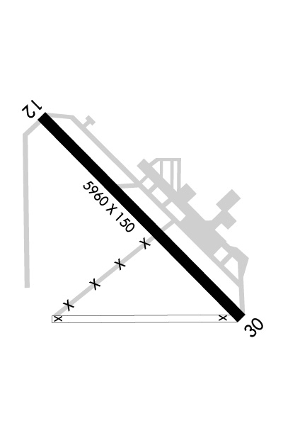
    Runway Identifications
    Runway Identification: 12/30
    Length: 5960 ft
    Width: 150 ft
    Surface: ASPHALT-GOOD CONDITION
    Edge lights: High Intensity

    Treatment: GROOVED

     Runway: 12   Runway: 30
    Mag heading: 120°Mag heading: 300°
    Rwy Slope: .20% UpRwy Slope: -.20% Down
    Approach: Approach:
    Pattern: Left TrafficPattern: Left Traffic
    Markings: NONPRECISION INSTRUMENTMarkings: NONPRECISION INSTRUMENT
    Marking Condition: FAIRMarking Condition: FAIR
    Arresting Dev: Arresting Dev:
    Lat & Long: N3602.1  W11904.2Lat. & Long.: N3601.4  W11903.3
    Elev: 431.2 ft. MSLElev: 443.1 ft. MSL
    TCH: 29 ft. AGLTCH: 60 ft. AGL
    Visual Glide Path: 3.00 degreesVisual Glide Path: 3.00 degrees
    Displaced Threshold: NoDisplaced Threshold: No
    Touchdown Zone: YESTouchdown Zone: YES
    Touchdown Elev.: 438.4 feetTouchdown Elev.: 443.2 feet
    Visual Glide Slope: 4-BOX VASI ON RIGHT SIDE OF RUNWAYVisual Glide Slope: 4-BOX VASI ON RIGHT SIDE OF RUNWAY
    RVR Equipment: RVR Equipment:
    RVV Equipment: NORVV Equipment: NO
    Approach Lights: Approach Lights:
    REIL: NOREIL: YES
    Centerline Lights: NOCenterline Lights: NO
    Touchdown lights: NOTouchdown lights: NO
    Runway Category: Runway with a Non-precision Approach having visibility minimums greater than 3/4 mileRunway Category: Runway with a Non-precision Approach having visibility minimums greater than 3/4 mile
    Declared Distances: Declared Distances:
    Obstructions: ROADObstructions: ROAD
    Marked: NOT Marked/LightedMarked: NOT Marked/Lighted
    Clearance slope: 18:1Clearance slope: 21:1
    Obstruction height: 15 feet AGLObstruction height: 15 feet AGL
    Dist. from runway: 480 feetDist. from runway: 520 feet
    Centerline offset: 292 left of centerlineCenterline offset: 298 feet left of centerline
    Comments: Comments:
    C:3/P: