KPTS

ATKINSON MUNI
PITTSBURG
KS
Time Zone: Central
Lat: N 3727.0
Long: W 09443.9
Elev: 946
Var: -02
Longest Runway: 6100
AWOS: 118.77
CTAF: 123.0

FBO & Flight Services info for KPTS

FBOs: Update your Fuel Prices

  click here  
100 LL Avgas & Jet A Fuel. Our terminal building offers a pilot waiting room/lounge, public waiting/lobby area, and restrooms. Atkinson's general aviation services include an airport courtesy car, ground communications outlet (frequency 121.725), flight planning/briefing area, AvFuel Points and AvFuel Contract Fuel, and aircraft maintenance and repairs.
Ph: 620-231-5760 Fax: 620-235-0092 Freq: 123.0WebsiteE-Mail
                                   
Service
Jet
100LL
SAF
MoGas
Fuel Avail: No Self Service
Full5.046.41    Last Update: 04/23/2024 14:34

Self        
Misc. Info: Address: 3510 AIRPORT DR   PITTSBURG, KS 66762

AWOSPh: 620-230-5654
-
Freq: 118.77  
If you are an FBO, call 1-203-262-1700 to update your info or email: FltPlan.Advertising@garmin.com
Advertise your FBO on FltPlan.com

Runway & Approach Info for KPTS
Rwy
Length
Land Dist**
Approach*
  Rwy
Length
Land Dist**
Approach*
04
4000x75  4000'          
 
  
22
  4000x75  4000'          
 
17
6100x100  6100'          
 
  
35
  6100x100  6100'          
 
 * only ILS, LOC, LDA, and SDF approaches to a specific runway are shown
** For any Declared Landing Distance Available, please see A/FD or Approach plates
Runway Weight Capability (lbs.) Help
Runway IDSingle WheelDouble WheelDouble Tandem WheelDual Double Wheel
04/2224,000N/AN/AN/A
17/3544,00058,000N/AN/A
These numbers are Advisory and are not limits.   The Airport Manager should have more accurate Weight Limits
Approach Charts
Approaches    
Current Weather/Notams
Customs Information Send updates to Support@FltPlan.com
Customs Not Available
Database effective 05/16/2024
Airport Diagram of KPTS
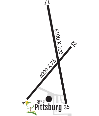
Airport Diagram might not be current.

Facility Name: ATKINSON MUNI
City Name: PITTSBURG
County: CRAWFORD
State abbrev: KS
State Name: KANSAS
   
Ownership: PUBLICLY OWNED
Use: OPEN TO THE PUBLIC
Owner's Name: CITY OF PITTSBURG
Address: 201 W 4TH ST
 PITTSBURG, KS 66762
Owner's Phone: 620-231-4100
  
Manager's Name: BILL PYLE
Address: 3510 ARPT DR
 PITTSBURG, KS 66762
Phone: 620-231-5760
   
FAA Region: CENTRAL
FAA Field Office: NONE


Sunrise / Sunset times for ATKINSON MUNI

DateSunriseSunset
04/25/24 Thursday6:3020:04
04/26/24 Friday6:2920:05
04/27/24 Saturday6:2820:06
04/28/24 Sunday6:2620:07
04/29/24 Monday6:2520:08
04/30/24 Tuesday6:2420:09
05/01/24 Wednesday6:2320:09
05/02/24 Thursday6:2220:10
05/03/24 Friday6:2120:11
05/04/24 Saturday6:2020:12
05/05/24 Sunday6:1920:13
05/06/24 Monday6:1720:14
05/07/24 Tuesday6:1620:15
05/08/24 Wednesday6:1520:16

Airport Facilities

Airport Attendance ScheduleMON-FRI 0700-1700, SAT-SUN 0800-1600
Airport Status OPERATIONAL (This Status can change at any time - please check NOTAMS)
Airport Lighting ScheduleDUSK-DAWN. ACTVT MIRL RYS 04/22 & 17/35; PAPI & REIL RYS 17, 35, 04 & 22 - CTAF.
Airport Storage AvailableTie Downs, Hanger
Extra Services AvailableAir Ambulance, Flight Instruction, Aircraft Rental
Wind IndicatorYES - (lighted)
Control TowerNO
CTAF Frequency123.000
Unicom Frequency123.000
Rotating Beacon ColorWG
Segmented CircleNO
Landing FeeNO

Airport Inspection Data

Airport InspectedSTATE - performed by STATE AERONAUTICAL PERSONNEL
Inspection Date09/19/2022

Airport Services

Type of Fuel AvailableGrade 100LL, JET A (freeze point -40C)
Airframe Repair ServiceMAJOR
Power Plant Repair ServiceMAJOR

Geographic Data

LatitudeN3727.0
LongitudeW09443.9 (ESTIMATED)
Arpt Elevation946ft (SURVEYED)
Magnetic Variation02E
3 miles NWof PITTSBURG
Traffic Pattern Altitude
Sectional ChartKANSAS CITY

Aircraft Data

Operations (Reported)YearlyAvg. Daily
General Aviation Transient 860024
General Aviation Local 1500041
Air Taxi 00
Commerical 00
Commuter 00
Military 1000
Aircraft based on Field
General Aviation Singles 21
General Aviation Multi 4
Jet Aircraft 4
General Aviation Helicopters 1
Military Aircraft 0
Gliders 0
Ultralights 0

FAA Services

FSS on field NO
FSS tie-in WICHITA
FSS Phone 1-800-WX-BRIEF
Who issues Notams ICT
Notam D service at airport YES
ARTCC Name KANSAS CITY

Federal Status

Airport Certification
Aircraft Rescue & Firefighting IndexNone
Airport of EntryNo
Custom Landing RightsNo
Joint Civil/MilitaryNo
Military Landing rightsYES

Federal Agreements

NATIONAL PLAN OF INTEGRATED AIRPORT SYSTEMS (NPIAS)
GRANT AGREEMENTS UNDER FAAP/ADAP/AIP
ASSURANCES PURSUANT TO TITLE VI, CIVIL RIGHTS ACT OF 1964
AGREEMENT UNDER DLAND OR DCLA HAS EXPIRED.

Remarks

BIRDS ON & INVOF ARPT.
GCO AVBL ON FREQ 121.725 THRU KANSAS CITY CENTER & FLT SVCS.
FOR CD IF UNA TO CTC ON FSS FREQ, CTC KANSAS CITY ARTCC AT 913-254-8508.
Airport Communications & Frequencies:
CTAF Frequency:
123.000
Unicom Frequency:
123.000
Remarks
  • APCH/DEP CTL SVC PRVDD BY KANSAS CITY ARTCC (ZKC) ON FREQS 128.6/282.325 (EDNA RCAG).
  • Runway Identifications
    Runway Identification: 04/22
    Length: 4000 ft
    Width: 75 ft
    Surface: ASPHALT-GOOD CONDITION
    Edge lights: Medium Intensity

    Treatment: NONE
    Weight: PCN 9 /F/D/X/T

     Runway: 04   Runway: 22
    Mag heading: 38°Mag heading: 218°
    Rwy Slope: -.60% DownRwy Slope: .60% Up
    Approach: Approach:
    Pattern: Left TrafficPattern: Left Traffic
    Markings: NONPRECISION INSTRUMENTMarkings: NONPRECISION INSTRUMENT
    Marking Condition: GOODMarking Condition: GOOD
    Arresting Dev: Arresting Dev:
    Lat & Long: N3726.6  W09444.2Lat. & Long.: N3727.1  W09443.7
    Elev: 946.2 ft. MSLElev: 922.3 ft. MSL
    TCH: 37 ft. AGLTCH: 55 ft. AGL
    Visual Glide Path: 3.00 degreesVisual Glide Path: 3.80 degrees
    Displaced Threshold: NoDisplaced Threshold: No
    Touchdown Zone: YESTouchdown Zone: YES
    Touchdown Elev.: 946.2 feetTouchdown Elev.: 941.8 feet
    Visual Glide Slope: 4-Light PAPI on LEFT side of RunwayVisual Glide Slope: 4-Light PAPI on LEFT side of Runway
    RVR Equipment: RVR Equipment:
    RVV Equipment: NORVV Equipment: NO
    Approach Lights: Approach Lights:
    REIL: YESREIL: YES
    Centerline Lights: NOCenterline Lights: NO
    Touchdown lights: NOTouchdown lights: NO
    Runway Category: Runway with a Non-precision Approach having visibility minimums greater than 3/4 mileRunway Category: Runway with a Non-precision Approach having visibility minimums greater than 3/4 mile
    Declared Distances: Declared Distances:
    Obstructions: TREESObstructions: TREES
    Marked: NOT Marked/LightedMarked: NOT Marked/Lighted
    Clearance slope: 5:1Clearance slope: 6:1
    Obstruction height: 44 feet AGLObstruction height: 56 feet AGL
    Dist. from runway: 450 feetDist. from runway: 579 feet
    Centerline offset: 148 left of centerlineCenterline offset: 190 feet right of centerline
    Comments: Comments:
    Runway Identification: 17/35
    Length: 6100 ft
    Width: 100 ft
    Surface: ASPHALT-GOOD CONDITION
    Edge lights: Medium Intensity

    Treatment: NONE
    Weight: PCN 17 /F/D/X/T

     Runway: 17   Runway: 35
    Mag heading: 168°Mag heading: 348°
    Rwy Slope: -.16% DownRwy Slope: .16% Up
    Approach: Approach:
    Pattern: Left TrafficPattern: Left Traffic
    Markings: NONPRECISION INSTRUMENTMarkings: NONPRECISION INSTRUMENT
    Marking Condition: GOODMarking Condition: GOOD
    Arresting Dev: Arresting Dev:
    Lat & Long: N3727.6  W09444.0Lat. & Long.: N3726.6  W09443.7
    Elev: 936.3 ft. MSLElev: 926.5 ft. MSL
    TCH: 43 ft. AGLTCH: 20 ft. AGL
    Visual Glide Path: 3.00 degreesVisual Glide Path: 3.00 degrees
    Displaced Threshold: NoDisplaced Threshold: No
    Touchdown Zone: YESTouchdown Zone: YES
    Touchdown Elev.: 936.3 feetTouchdown Elev.: 929.4 feet
    Visual Glide Slope: 4-Light PAPI on LEFT side of RunwayVisual Glide Slope: 4-Light PAPI on LEFT side of Runway
    RVR Equipment: RVR Equipment:
    RVV Equipment: NORVV Equipment: NO
    Approach Lights: Approach Lights:
    REIL: YESREIL: YES
    Centerline Lights: NOCenterline Lights: NO
    Touchdown lights: NOTouchdown lights: NO
    Runway Category: Runway with a Non-precision Approach having visibility minimums greater than 3/4 mileRunway Category: Runway with a Non-precision Approach having visibility minimums greater than 3/4 mile
    Declared Distances: Declared Distances:
    Obstructions: TREESObstructions: TREES
    Marked: NOT Marked/LightedMarked: NOT Marked/Lighted
    Clearance slope: 30:1Clearance slope: 30:1
    Obstruction height: 70 feet AGLObstruction height: 50 feet AGL
    Dist. from runway: 2369 feetDist. from runway: 1726 feet
    Centerline offset: 10 right of centerlineCenterline offset: 410 feet right of centerline
    Comments: Comments:
    C:17/P: