Current Weather/Notams (Metars, TAFs, Notams, NWS Forecast, PIREPS, and nearby weather)
Customs Information Send updates to Support@FltPlan.com
Customs Not Available
Database effective 05/16/2024
Airport Diagram might not be current.
|
| Facility Name: | HARRY P WILLIAMS MEML |
| City Name: | PATTERSON |
| County: | ST MARY |
| State abbrev: | LA |
| State Name: | LOUISIANA |
| | |
| Ownership: | PUBLICLY OWNED |
| Use: | OPEN TO THE PUBLIC |
| Owner's Name: | STATE OF LOUISIANA |
| Address: | DOTD AVIATION SECTION, PO BOX 94245 |
| | BATON ROUGE, LA 70804 |
| Owner's Phone: | 225-379-3950 |
| | |
| Manager's Name: | MR. JEAN PAUL BOURG |
| Address: | 500 MAIN ST, 5TH FLOOR COURTHOUSE |
| | FRANKLIN, LA 70538 |
| Phone: | 337-828-4100 |
| | |
| FAA Region: | SOUTHWEST |
| FAA Field Office: | LNM |
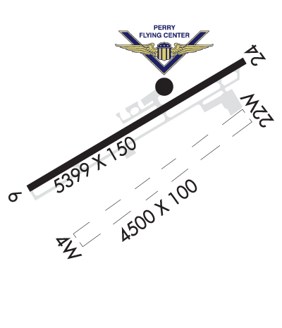
Runway Identifications
Runway Identification: 04W/22WLength: 4500 ft
Width: 100 ft
Surface: WATER-GOOD CONDITION
Edge lights: Treatment: NONE
| | Runway: 04W | | Runway: 22W |
| Mag heading: | 54° | Mag heading: | 234° |
| Rwy Slope: | .00% | Rwy Slope: | .00% |
| Approach: | | Approach: | |
| Pattern: | Right Traffic | Pattern: | Left Traffic |
| Markings: | | Markings: | |
| Marking Condition: | | Marking Condition: | |
| Arresting Dev: | | Arresting Dev: | |
| Lat & Long: | N2942.3 W09120.6 | Lat. & Long.: | N2942.7 W09119.9 |
| Elev: | 1.0 ft. MSL | Elev: | 1.0 ft. MSL |
| TCH: | | TCH: | |
| Visual Glide Path: | | Visual Glide Path: | |
| Displaced Threshold: | No | Displaced Threshold: | No |
| Touchdown Zone: | YES | Touchdown Zone: | YES |
| Touchdown Elev.: | 1.0 feet | Touchdown Elev.: | 1.0 feet |
| Visual Glide Slope: | | Visual Glide Slope: | |
| RVR Equipment: | | RVR Equipment: | |
| RVV Equipment: | NO | RVV Equipment: | NO |
| Approach Lights: | | Approach Lights: | |
| REIL: | NO | REIL: | NO |
| Centerline Lights: | NO | Centerline Lights: | NO |
| Touchdown lights: | NO | Touchdown lights: | NO |
| Runway Category: | Runway with a Visual Approach | Runway Category: | Runway with a Visual Approach |
| Declared Distances: | | Declared Distances: | |
| Obstructions: | ROAD | Obstructions: | |
| Marked: | NOT Marked/Lighted | Marked: | |
| Clearance slope: | 30:1 | Clearance slope: | 20:1 |
| Obstruction height: | 20 feet AGL | Obstruction height: | |
| Dist. from runway: | 600 feet | Dist. from runway: | |
| Centerline offset: | | Centerline offset: | |
| Comments: | | Comments: | |
Runway Identification: 06/24Length: 5399 ft
Width: 150 ft
Surface: ASPHALT-FAIR CONDITION
Edge lights: Medium IntensityTreatment: NONE
| | Runway: 06 | | Runway: 24 |
| Mag heading: | 58° | Mag heading: | 238° |
| Rwy Slope: | .03% Up | Rwy Slope: | -.03% Down |
| Approach: | | Approach: | ILS/DME |
| Pattern: | Left Traffic | Pattern: | Right Traffic |
| Markings: | NONPRECISION INSTRUMENT | Markings: | PRECISION INSTRUMENT |
| Marking Condition: | FAIR | Marking Condition: | FAIR |
| Arresting Dev: | | Arresting Dev: | |
| Lat & Long: | N2942.4 W09120.8 | Lat. & Long.: | N2942.9 W09119.9 |
| Elev: | 6.7 ft. MSL | Elev: | 8.4 ft. MSL |
| TCH: | 50 ft. AGL | TCH: | 50 ft. AGL |
| Visual Glide Path: | 3.00 degrees | Visual Glide Path: | 3.00 degrees |
| Displaced Threshold: | 394 feet | Displaced Threshold: | No |
| Touchdown Zone: | YES | Touchdown Zone: | YES |
| Touchdown Elev.: | 8.5 feet | Touchdown Elev.: | 8.5 feet |
| Visual Glide Slope: | 2-Light PAPI on LEFT side of Runway | Visual Glide Slope: | 2-Light PAPI on LEFT side of Runway |
| RVR Equipment: | | RVR Equipment: | |
| RVV Equipment: | NO | RVV Equipment: | NO |
| Approach Lights: | | Approach Lights: | MALSR - 1,400 foot medium intensity approach lighting system with runway alignment indicator lights |
| REIL: | YES | REIL: | NO |
| Centerline Lights: | NO | Centerline Lights: | NO |
| Touchdown lights: | NO | Touchdown lights: | NO |
| Runway Category: | Runway with a Non-precision Approach having visibility minimums greater than 3/4 mile | Runway Category: | Precision Instrument Runway |
| Declared Distances: | | Declared Distances: | |
| Obstructions: | TREES | Obstructions: | |
| Marked: | NOT Marked/Lighted | Marked: | |
| Clearance slope: | 22:1; APCH RATIO 23:1 TO DTHR. | Clearance slope: | 50:1 |
| Obstruction height: | 58 feet AGL | Obstruction height: | |
| Dist. from runway: | 1491 feet | Dist. from runway: | |
| Centerline offset: | 262 left of centerline | Centerline offset: | |
| Comments: | | Comments: | |

