Current Weather/Notams (Metars, TAFs, Notams, NWS Forecast, PIREPS, and nearby weather)
Customs Information Send updates to Support@FltPlan.com
Customs Not Available
Database effective 05/16/2024
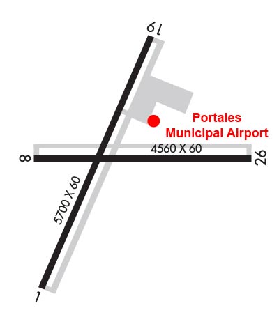
Airport Diagram might not be current. Facility Name: PORTALES MUNI City Name: PORTALES County: ROOSEVELT State abbrev: NM State Name: NEW MEXICO Ownership: PUBLICLY OWNED Use: OPEN TO THE PUBLIC Owner's Name: CITY OF PORTALES Address: 100 W. 1ST ST. PORTALES, NM 88130 Owner's Phone: 575-356-6662 Manager's Name: KELLY MCCLELLAN Address: 181 AIRPORT RD PORTALES, NM 88130 Phone: 575-478-2863 FAA Region: SOUTHWEST FAA Field Office: LNM
Runway Identifications Help
Runway Identification: 01/19 Length: 5700 ftWidth: 60 ftSurface: ASPHALT-FAIR CONDITIONEdge lights: Medium Intensity Treatment: NONEWeight: PCN 4 /F/C/Y/T Runway: 01 Runway: 19 Mag heading: 14° Mag heading: 194° Rwy Slope: -.59% Down Rwy Slope: .59% Up Approach: Approach: Pattern: Left Traffic Pattern: Left Traffic Markings: NONPRECISION INSTRUMENT Markings: NONPRECISION INSTRUMENT Marking Condition: GOOD Marking Condition: GOOD Arresting Dev: Arresting Dev: Lat & Long: N3408.3 W10324.9 Lat. & Long.: N3409.2 W10324.5 Elev: 4078.0 ft. MSL Elev: 4044.1 ft. MSL TCH: TCH: 34 ft. AGL Visual Glide Path: Visual Glide Path: 3.50 degrees Displaced Threshold: No Displaced Threshold: No Touchdown Zone: YES Touchdown Zone: YES Touchdown Elev.: 4078.0 feet Touchdown Elev.: 4063.1 feet Visual Glide Slope: Visual Glide Slope: PULSATING/STEADY BURNING VASI ON LEFT SIDE OF RUNWAY; PVASI OTS INDEFLY. RVR Equipment: RVR Equipment: RVV Equipment: NO RVV Equipment: NO Approach Lights: Approach Lights: REIL: NO REIL: NO Centerline Lights: NO Centerline Lights: NO Touchdown lights: NO Touchdown lights: NO Runway Category: Runway with a Non-precision Approach Runway Category: Runway with a Visual Approach Declared Distances: Declared Distances:
Runway Identification: 08/26 Length: 4560 ftWidth: 60 ftSurface: ASPHALT-GOOD CONDITIONEdge lights: Medium Intensity Treatment: NONEWeight: PCN 4 /F/C/Y/T Runway: 08 Runway: 26 Mag heading: 81° Mag heading: 261° Rwy Slope: -.18% Down Rwy Slope: .18% Up Approach: Approach: Pattern: Left Traffic Pattern: Left Traffic Markings: NONPRECISION INSTRUMENT Markings: NONPRECISION INSTRUMENT Marking Condition: FAIR Marking Condition: FAIR Arresting Dev: Arresting Dev: Lat & Long: N3408.7 W10325.0 Lat. & Long.: N3408.7 W10324.1 Elev: 4066.3 ft. MSL Elev: 4058.2 ft. MSL TCH: TCH: 23 ft. AGL Visual Glide Path: Visual Glide Path: 3.00 degrees Displaced Threshold: No Displaced Threshold: No Touchdown Zone: YES Touchdown Zone: YES Touchdown Elev.: 4066.3 feet Touchdown Elev.: 4060.3 feet Visual Glide Slope: Visual Glide Slope: PULSATING/STEADY BURNING VASI ON LEFT SIDE OF RUNWAY; PVASI OTS INDEFLY. RVR Equipment: RVR Equipment: RVV Equipment: NO RVV Equipment: NO Approach Lights: Approach Lights: REIL: NO REIL: NO Centerline Lights: NO Centerline Lights: NO Touchdown lights: NO Touchdown lights: NO Runway Category: Runway with a Visual Approach Runway Category: Runway with a Visual Approach Declared Distances: Declared Distances: Obstructions: Obstructions: PLINE Marked: Marked: MARKED Clearance slope: 50:1 Clearance slope: 34:1 Obstruction height: Obstruction height: 30 feet AGL Dist. from runway: Dist. from runway: 1200 feet Centerline offset: Centerline offset: Comments: Comments: