
| ||||||||||||||||||||||||||||||||||||||||||||
| ||||||||||||||||||||||||||||||||||||||||||||
| ||||||||||||||||||||||||||||||||||||||||||||
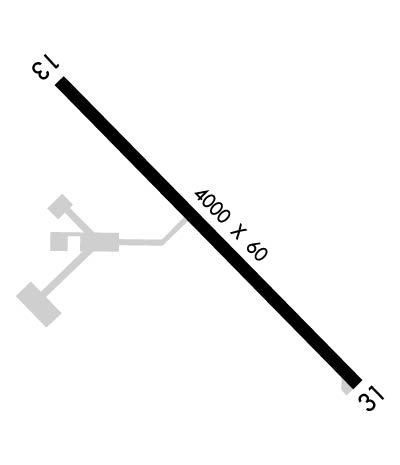
| Rwy | Rwy | |||||||
| 4000x60 | 4000' | 4000x60 | 4000' | |||||
| Runway ID | Single Wheel | Double Wheel | Double Tandem Wheel | Dual Double Wheel |
| 13/31 | 12,000 | N/A | N/A | N/A |
| These numbers are Advisory and are not limits. The Airport Manager should have more accurate Weight Limits | ||||
 Airport Diagram might not be current. | |
| Facility Name: | PITTSFIELD PENSTONE MUNI |
| City Name: | PITTSFIELD |
| County: | PIKE |
| State abbrev: | IL |
| State Name: | ILLINOIS |
| Ownership: | PUBLICLY OWNED |
| Use: | OPEN TO THE PUBLIC |
| Owner's Name: | CITY OF PITTSFIELD |
| Address: | 215 N. MONROE ST |
| PITTSFIELD, IL 62363 | |
| Owner's Phone: | 217-285-4484 |
| Manager's Name: | MARK GERARD |
| Address: | 29296 US HWY 54 |
| PITTSFIELD, IL 62363 | |
| Phone: | 217-285-6027 |
| FAA Region: | GREAT LAKES |
| FAA Field Office: | CHI |
| Date | Sunrise | Sunset |
|---|---|---|
| 04/24/24 Wednesday | 6:12 | 19:51 |
| 04/25/24 Thursday | 6:11 | 19:52 |
| 04/26/24 Friday | 6:09 | 19:53 |
| 04/27/24 Saturday | 6:08 | 19:54 |
| 04/28/24 Sunday | 6:07 | 19:55 |
| 04/29/24 Monday | 6:05 | 19:56 |
| 04/30/24 Tuesday | 6:04 | 19:57 |
| 05/01/24 Wednesday | 6:03 | 19:58 |
| 05/02/24 Thursday | 6:02 | 19:59 |
| 05/03/24 Friday | 6:01 | 20:00 |
| 05/04/24 Saturday | 5:59 | 20:01 |
| 05/05/24 Sunday | 5:58 | 20:02 |
| 05/06/24 Monday | 5:57 | 20:03 |
| 05/07/24 Tuesday | 5:56 | 20:04 |
| Airport Attendance Schedule | MON-FRI 0800-1700 |
| Airport Status | OPERATIONAL (This Status can change at any time - please check NOTAMS) |
| Airport Lighting Schedule | MIRL RY 13/31 PRESET ON LOW INTST; TO INCREASE INTST & ACTVT MIRL RY 13/31 - CTAF. |
| Airport Storage Available | Tie Downs, Hanger |
| Extra Services Available | NONE |
| Wind Indicator | YES - (lighted) |
| Control Tower | NO |
| CTAF Frequency | 122.800 |
| Unicom Frequency | 122.800 |
| Rotating Beacon Color | WG |
| Segmented Circle | YES |
| Landing Fee | NO |
| Airport Inspected | STATE - performed by STATE AERONAUTICAL PERSONNEL |
| Inspection Date | 05/25/2021 |
| Type of Fuel Available | Grade 100LL, JET A (freeze point -40C); -1024 HR SELF SVC CREDIT CARD (MAJOR) FUEL FAC. |
| Airframe Repair Service | None |
| Power Plant Repair Service | None |
| Latitude | N3938.3 |
| Longitude | W09046.7 (ESTIMATED) |
| Arpt Elevation | 709ft (SURVEYED) |
| Magnetic Variation | 02E |
| 3 miles NE | of PITTSFIELD |
| Traffic Pattern Altitude | |
| Sectional Chart | ST LOUIS |
| Operations (Reported) | Yearly | Avg. Daily |
|---|---|---|
| General Aviation Transient | 2000 | 5 |
| General Aviation Local | 4700 | 13 |
| Air Taxi | 200 | 1 |
| Commerical | 0 | 0 |
| Commuter | 0 | 0 |
| Military | 100 | 0 |
| Aircraft based on Field | |
|---|---|
| General Aviation Singles | 7 |
| General Aviation Multi | 2 |
| Jet Aircraft | 1 |
| General Aviation Helicopters | 0 |
| Military Aircraft | 0 |
| Gliders | 0 |
| Ultralights | 0 |
| FSS on field | NO |
| FSS tie-in | SAINT LOUIS |
| FSS Phone | 1-800-WX-BRIEF |
| Who issues Notams | PPQ |
| Notam D service at airport | YES |
| ARTCC Name | KANSAS CITY |
| Airport Certification | |
| Aircraft Rescue & Firefighting Index | None |
| Airport of Entry | No |
| Custom Landing Rights | No |
| Joint Civil/Military | No |
| Military Landing rights | YES |
| NATIONAL PLAN OF INTEGRATED AIRPORT SYSTEMS (NPIAS) |
| GRANT AGREEMENTS UNDER FAAP/ADAP/AIP |
| ASSURANCES PURSUANT TO TITLE VI, CIVIL RIGHTS ACT OF 1964 |
| DEER & MIGRATORY WATERFOWL ON & INVOF ARPT. |
| (E81) TWY LGTS ARE LGTD EXIT ARROWS. |
| FOR CD CTC KANSAS CITY ARTCC AT 913-254-8508. |
Airport Communications & Frequencies:
| |||||||||
| Runway: 13 | Runway: 31 | ||
| Mag heading: | 133° | Mag heading: | 313° |
| Rwy Slope: | -.38% Down | Rwy Slope: | .38% Up |
| Approach: | Approach: | ||
| Pattern: | Left Traffic | Pattern: | Left Traffic |
| Markings: | NONPRECISION INSTRUMENT | Markings: | NONPRECISION INSTRUMENT |
| Marking Condition: | POOR; RWY 13 MARKINGS POOR DUE TO FADING. | Marking Condition: | POOR; RWY 31 MARKINGS POOR DUE TO FADING. |
| Arresting Dev: | Arresting Dev: | ||
| Lat & Long: | N3938.6 W09047.0 | Lat. & Long.: | N3938.1 W09046.4 |
| Elev: | 709.8 ft. MSL | Elev: | 694.6 ft. MSL |
| TCH: | 32 ft. AGL | TCH: | 29 ft. AGL |
| Visual Glide Path: | 3.00 degrees | Visual Glide Path: | 3.00 degrees |
| Displaced Threshold: | No | Displaced Threshold: | No |
| Touchdown Zone: | YES | Touchdown Zone: | YES |
| Touchdown Elev.: | 709.8 feet | Touchdown Elev.: | 704.5 feet |
| Visual Glide Slope: | 2-Light PAPI on LEFT side of Runway; RY 13 PAPI, OPERATE CONTINUOUSLY. | Visual Glide Slope: | 2-Light PAPI on LEFT side of Runway; RY 31 PAPI, OPERATE CONTINUOUSLY. |
| RVR Equipment: | RVR Equipment: | ||
| RVV Equipment: | NO | RVV Equipment: | NO |
| Approach Lights: | Approach Lights: | ||
| REIL: | NO | REIL: | NO |
| Centerline Lights: | NO | Centerline Lights: | NO |
| Touchdown lights: | NO | Touchdown lights: | NO |
| Runway Category: | Runway with a Non-precision Approach | Runway Category: | Runway with a Non-precision Approach |
| Declared Distances: | Declared Distances: |
