Current Weather/Notams (Metars, TAFs, Notams, NWS Forecast, PIREPS, and nearby weather)
Customs Information Send updates to Support@FltPlan.com
Customs Not Available
Database effective 05/16/2024
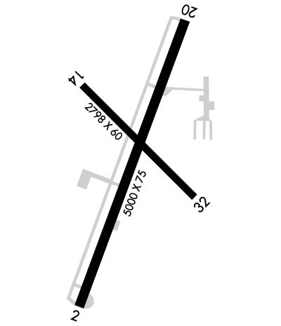
Airport Diagram might not be current.
|
| Facility Name: | LA PORTE MUNI |
| City Name: | LA PORTE |
| County: | LA PORTE |
| State abbrev: | IN |
| State Name: | INDIANA |
| | |
| Ownership: | PUBLICLY OWNED |
| Use: | OPEN TO THE PUBLIC |
| Owner's Name: | LA PORTE ARPT AUTH; EDWARD VOLK |
| Address: | 2341 STATE RD 39S |
| | LA PORTE, IN 46350 |
| Owner's Phone: | 219-324-3393 |
| | |
| Manager's Name: | ERIC BOBCEK |
| Address: | 2341 STATE RD 39S |
| | LA PORTE, IN 46350 |
| Phone: | 219-324-3393 |
| | |
| FAA Region: | GREAT LAKES |
| FAA Field Office: | CHI |
Runway Identifications
Runway Identification: 02/20Length: 5000 ft
Width: 75 ft
Surface: ASPHALT-GOOD CONDITION
Edge lights: Medium IntensityTreatment: GROOVED
| | Runway: 02 | | Runway: 20 |
| Mag heading: | 23° | Mag heading: | 203° |
| Rwy Slope: | .23% Up | Rwy Slope: | -.23% Down |
| Approach: | LOCALIZER | Approach: | |
| Pattern: | Left Traffic | Pattern: | Left Traffic |
| Markings: | NONPRECISION INSTRUMENT | Markings: | NONPRECISION INSTRUMENT |
| Marking Condition: | GOOD | Marking Condition: | GOOD |
| Arresting Dev: | | Arresting Dev: | |
| Lat & Long: | N4133.9 W08644.3 | Lat. & Long.: | N4134.7 W08643.9 |
| Elev: | 800.3 ft. MSL | Elev: | 811.9 ft. MSL |
| TCH: | 24 ft. AGL | TCH: | 27 ft. AGL |
| Visual Glide Path: | 3.00 degrees | Visual Glide Path: | 3.45 degrees |
| Displaced Threshold: | No | Displaced Threshold: | No |
| Touchdown Zone: | YES | Touchdown Zone: | YES |
| Touchdown Elev.: | 804.5 feet | Touchdown Elev.: | 812.0 feet |
| Visual Glide Slope: | 2-Light PAPI on LEFT side of Runway | Visual Glide Slope: | 2-Light PAPI on LEFT side of Runway |
| RVR Equipment: | | RVR Equipment: | |
| RVV Equipment: | NO | RVV Equipment: | NO |
| Approach Lights: | | Approach Lights: | |
| REIL: | YES | REIL: | YES |
| Centerline Lights: | NO | Centerline Lights: | NO |
| Touchdown lights: | NO | Touchdown lights: | NO |
| Runway Category: | Runway with a Non-precision Approach | Runway Category: | Runway with a Non-precision Approach |
| Declared Distances: | | Declared Distances: | |
| Obstructions: | CROPS | Obstructions: | CROPS |
| Marked: | NOT Marked/Lighted | Marked: | NOT Marked/Lighted |
| Clearance slope: | | Clearance slope: | |
| Obstruction height: | 10 feet AGL | Obstruction height: | 10 feet AGL |
| Dist. from runway: | 201 feet | Dist. from runway: | 201 feet |
| Centerline offset: | 240 right of centerline | Centerline offset: | 160 feet left of centerline |
| Comments: | | Comments: | 10 FT CROPS 160 FT L OF RWY END. |
Runway Identification: 14/32Length: 2797 ft
Width: 60 ft
Surface: ASPHALT-GOOD CONDITION
Edge lights: Medium IntensityTreatment: NONE
| | Runway: 14 | | Runway: 32 |
| Mag heading: | 138° | Mag heading: | 318° |
| Rwy Slope: | -.38% Down | Rwy Slope: | .38% Up |
| Approach: | | Approach: | |
| Pattern: | Left Traffic | Pattern: | Left Traffic |
| Markings: | BASIC | Markings: | BASIC |
| Marking Condition: | GOOD | Marking Condition: | GOOD |
| Arresting Dev: | | Arresting Dev: | |
| Lat & Long: | N4134.6 W08644.3 | Lat. & Long.: | N4134.2 W08643.9 |
| Elev: | 810.0 ft. MSL | Elev: | 799.3 ft. MSL |
| TCH: | | TCH: | 33 ft. AGL |
| Visual Glide Path: | | Visual Glide Path: | 3.50 degrees |
| Displaced Threshold: | 199 feet | Displaced Threshold: | 198 feet |
| Touchdown Zone: | YES | Touchdown Zone: | YES |
| Touchdown Elev.: | 810.2 feet | Touchdown Elev.: | 810.2 feet |
| Visual Glide Slope: | | Visual Glide Slope: | 2-Light PAPI on LEFT side of Runway; UNUSBL BYD 2 DEGS LEFT OF CNTRLN. |
| RVR Equipment: | | RVR Equipment: | |
| RVV Equipment: | NO | RVV Equipment: | NO |
| Approach Lights: | | Approach Lights: | |
| REIL: | YES | REIL: | YES |
| Centerline Lights: | NO | Centerline Lights: | NO |
| Touchdown lights: | NO | Touchdown lights: | NO |
| Runway Category: | Runway with a Visual Approach | Runway Category: | Runway with a Visual Approach |
| Declared Distances: | | Declared Distances: | |
| Obstructions: | CROPS | Obstructions: | CROPS |
| Marked: | NOT Marked/Lighted | Marked: | NOT Marked/Lighted |
| Clearance slope: | APCH SLOPE 35:1 FM DTHR. | Clearance slope: | |
| Obstruction height: | 10 feet AGL | Obstruction height: | 10 feet AGL |
| Dist. from runway: | 201 feet | Dist. from runway: | 201 feet |
| Centerline offset: | CLOSEST INTCP POINT. | Centerline offset: | CLOSEST INTCP POINT. |
| Comments: | 10 FT CROPS 80 FT FM RWY END 75 FT R & 150 FT L. | Comments: | |

