Current Weather/Notams (Metars, TAFs, Notams, NWS Forecast, PIREPS, and nearby weather)
Customs Information Send updates to Support@FltPlan.com
Customs Not Available
Database effective 05/16/2024
Airport Diagram might not be current.
|
| Facility Name: | PERRY LEFORS FLD |
| City Name: | PAMPA |
| County: | GRAY |
| State abbrev: | TX |
| State Name: | TEXAS |
| | |
| Ownership: | PUBLICLY OWNED |
| Use: | OPEN TO THE PUBLIC |
| Owner's Name: | GRAY COUNTY |
| Address: | GRAY CO COURTHOUSE |
| | PAMPA, TX 79065 |
| Owner's Phone: | 806-669-8007 |
| | |
| Manager's Name: | CHRIS PORTER |
| Address: | 205 N. RUSSELL |
| | PAMPA, TX 79065 |
| Phone: | (806) 669-8007; ALSO, PAUL LOYD, 806-663-1008. |
| | |
| FAA Region: | SOUTHWEST |
| FAA Field Office: | TEX |
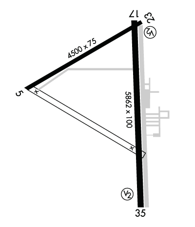
Runway Identifications
Runway Identification: 05/23Length: 4500 ft
Width: 75 ft
Surface: ASPHALT-GOOD CONDITION
Edge lights: Medium IntensityTreatment: NONE
| | Runway: 05 | | Runway: 23 |
| Mag heading: | 54° | Mag heading: | 234° |
| Rwy Slope: | -.10% Down | Rwy Slope: | .10% Up |
| Approach: | | Approach: | |
| Pattern: | Left Traffic | Pattern: | Left Traffic |
| Markings: | BASIC | Markings: | BASIC |
| Marking Condition: | GOOD | Marking Condition: | GOOD |
| Arresting Dev: | | Arresting Dev: | |
| Lat & Long: | N3536.8 W10100.4 | Lat. & Long.: | N3537.2 W10059.6 |
| Elev: | 3242.5 ft. MSL | Elev: | 3238.1 ft. MSL |
| TCH: | | TCH: | |
| Visual Glide Path: | | Visual Glide Path: | |
| Displaced Threshold: | No | Displaced Threshold: | No |
| Touchdown Zone: | YES | Touchdown Zone: | YES |
| Touchdown Elev.: | 3244.2 feet | Touchdown Elev.: | 3244.2 feet |
| Visual Glide Slope: | | Visual Glide Slope: | |
| RVR Equipment: | | RVR Equipment: | |
| RVV Equipment: | NO | RVV Equipment: | NO |
| Approach Lights: | | Approach Lights: | |
| REIL: | NO | REIL: | NO |
| Centerline Lights: | NO | Centerline Lights: | NO |
| Touchdown lights: | NO | Touchdown lights: | NO |
| Runway Category: | Runway with a Visual Approach | Runway Category: | Runway with a Visual Approach |
| Declared Distances: | | Declared Distances: | |
| Obstructions: | | Obstructions: | PLINE |
| Marked: | | Marked: | MARKED |
| Clearance slope: | 50:1 | Clearance slope: | 28:1 |
| Obstruction height: | | Obstruction height: | 25 feet AGL |
| Dist. from runway: | | Dist. from runway: | 900 feet |
| Centerline offset: | | Centerline offset: | 25 feet right of centerline |
| Comments: | | Comments: | |
Runway Identification: 17/35Length: 5862 ft
Width: 100 ft
Surface: ASPHALT-GOOD CONDITION
Edge lights: Medium IntensityTreatment: NONE
| | Runway: 17 | | Runway: 35 |
| Mag heading: | 174° | Mag heading: | 354° |
| Rwy Slope: | .03% Up | Rwy Slope: | -.03% Down |
| Approach: | | Approach: | |
| Pattern: | Left Traffic | Pattern: | Left Traffic |
| Markings: | NONPRECISION INSTRUMENT | Markings: | NONPRECISION INSTRUMENT |
| Marking Condition: | GOOD | Marking Condition: | GOOD |
| Arresting Dev: | | Arresting Dev: | |
| Lat & Long: | N3537.1 W10059.6 | Lat. & Long.: | N3536.1 W10059.6 |
| Elev: | 3238.9 ft. MSL | Elev: | 3240.7 ft. MSL |
| TCH: | 45 ft. AGL | TCH: | 45 ft. AGL |
| Visual Glide Path: | 3.00 degrees | Visual Glide Path: | 3.00 degrees |
| Displaced Threshold: | No | Displaced Threshold: | No |
| Touchdown Zone: | YES | Touchdown Zone: | YES |
| Touchdown Elev.: | 3243.7 feet | Touchdown Elev.: | 3245.2 feet |
| Visual Glide Slope: | 2-Light PAPI on LEFT side of Runway | Visual Glide Slope: | 2-Light PAPI on LEFT side of Runway |
| RVR Equipment: | | RVR Equipment: | |
| RVV Equipment: | NO | RVV Equipment: | NO |
| Approach Lights: | | Approach Lights: | |
| REIL: | NO | REIL: | NO |
| Centerline Lights: | NO | Centerline Lights: | NO |
| Touchdown lights: | NO | Touchdown lights: | NO |
| Runway Category: | Runway with a Non-precision Approach having visibility minimums greater than 3/4 mile | Runway Category: | Runway with a Visual Approach |
| Declared Distances: | | Declared Distances: | |
| Obstructions: | ROAD | Obstructions: | |
| Marked: | NOT Marked/Lighted | Marked: | |
| Clearance slope: | 35:1 | Clearance slope: | 50:1 |
| Obstruction height: | 15 feet AGL | Obstruction height: | |
| Dist. from runway: | 730 feet | Dist. from runway: | |
| Centerline offset: | | Centerline offset: | |
| Comments: | TAIL HGT OF AIRPLANE ON RWY 05/23, 173 FT FM CNTRLN TO THR. | Comments: | |

