Current Weather/Notams (Metars, TAFs, Notams, NWS Forecast, PIREPS, and nearby weather)
Customs Information Send updates to Support@FltPlan.com
Customs Not Available
Database effective 05/16/2024
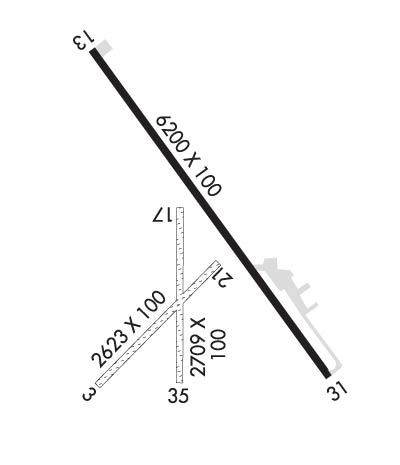
Airport Diagram might not be current. Facility Name: POWELL MUNI City Name: POWELL County: PARK State abbrev: WY State Name: WYOMING Ownership: PUBLICLY OWNED Use: OPEN TO THE PUBLIC Owner's Name: CITY OF POWELL Address: 270 NORTH CLARK POWELL, WY 82435 Owner's Phone: 307-754-6921 Manager's Name: BEN HUBBARD; ADNL CTC BEN HUBBARD 307-754-6922. Address: 270 NORTH CLARK POWELL, WY 82435 Phone: 307-754-5234; CELL 307-254-0256. FAA Region: NORTHWEST MOUNTAIN FAA Field Office: DEN
Runway Identifications Help
Runway Identification: 03/21 Length: 2623 ftWidth: 100 ftSurface: GRASS NATURAL SOIL-FAIR CONDITIONEdge lights: Treatment: NONE Runway: 03 Runway: 21 Mag heading: 33° Mag heading: 213° Rwy Slope: .69% Up Rwy Slope: -.69% Down Approach: Approach: Pattern: Left Traffic Pattern: Left Traffic Markings: NONE Markings: NONE Marking Condition: FAIR Marking Condition: FAIR Arresting Dev: Arresting Dev: Lat & Long: N4451.7 W10847.9 Lat. & Long.: N4452.0 W10847.5 Elev: 5037.0 ft. MSL Elev: 5055.0 ft. MSL TCH: TCH: Visual Glide Path: Visual Glide Path: Displaced Threshold: No Displaced Threshold: No Touchdown Zone: YES Touchdown Zone: YES Touchdown Elev.: 5055.0 feet Touchdown Elev.: 5055.0 feet Visual Glide Slope: Visual Glide Slope: RVR Equipment: RVR Equipment: RVV Equipment: NO RVV Equipment: NO Approach Lights: Approach Lights: REIL: NO REIL: NO Centerline Lights: NO Centerline Lights: NO Touchdown lights: NO Touchdown lights: NO Runway Category: Runway with a Visual Approach Runway Category: Runway with a Visual Approach Declared Distances: Declared Distances: Obstructions: FENCE Obstructions: Marked: NOT Marked/Lighted Marked: Clearance slope: 21:1 Clearance slope: 50:1 Obstruction height: 12 feet AGL Obstruction height: Dist. from runway: 252 feet Dist. from runway: Centerline offset: 21 right of centerline Centerline offset: Comments: Comments:
Runway Identification: 13/31 Length: 6200 ftWidth: 100 ftSurface: ASPHALT-GOOD CONDITIONEdge lights: Medium Intensity Treatment: NONE Runway: 13 Runway: 31 Mag heading: 134° Mag heading: 314° Rwy Slope: 1.59% Up Rwy Slope: -1.59% Down Approach: Approach: Pattern: Left Traffic Pattern: Left Traffic Markings: NONPRECISION INSTRUMENT Markings: NONPRECISION INSTRUMENT Marking Condition: GOOD Marking Condition: GOOD Arresting Dev: Arresting Dev: Lat & Long: N4452.6 W10848.0 Lat. & Long.: N4451.7 W10847.1 Elev: 4997.2 ft. MSL Elev: 5095.7 ft. MSL TCH: 38 ft. AGL TCH: 36 ft. AGL Visual Glide Path: 3.00 degrees Visual Glide Path: 3.00 degrees Displaced Threshold: No Displaced Threshold: No Touchdown Zone: YES Touchdown Zone: YES Touchdown Elev.: 5046.3 feet Touchdown Elev.: 5095.7 feet Visual Glide Slope: 2-Light PAPI on LEFT side of Runway Visual Glide Slope: 2-Light PAPI on LEFT side of Runway RVR Equipment: RVR Equipment: RVV Equipment: NO RVV Equipment: NO Approach Lights: Approach Lights: REIL: NO REIL: YES Centerline Lights: NO Centerline Lights: NO Touchdown lights: NO Touchdown lights: NO Runway Category: Runway with a Non-precision Approach having visibility minimums greater than 3/4 mile Runway Category: Runway with a Non-precision Approach having visibility minimums greater than 3/4 mile Declared Distances: Declared Distances: Obstructions: Obstructions: FENCE Marked: Marked: NOT Marked/Lighted Clearance slope: 50:1 Clearance slope: 38:1 Obstruction height: Obstruction height: 25 feet AGL Dist. from runway: Dist. from runway: 1150 feet Centerline offset: Centerline offset: Comments: Comments:
Runway Identification: 17/35 Length: 2709 ftWidth: 100 ftSurface: GRASS NATURAL SOIL-FAIR CONDITIONEdge lights: Treatment: NONE Runway: 17 Runway: 35 Mag heading: 169° Mag heading: 349° Rwy Slope: .75% Up Rwy Slope: -.75% Down Approach: Approach: Pattern: Left Traffic Pattern: Left Traffic Markings: NONE Markings: NONE Marking Condition: FAIR Marking Condition: FAIR Arresting Dev: Arresting Dev: Lat & Long: N4452.2 W10847.6 Lat. & Long.: N4451.7 W10847.6 Elev: 5037.6 ft. MSL Elev: 5057.8 ft. MSL TCH: TCH: Visual Glide Path: Visual Glide Path: Displaced Threshold: No Displaced Threshold: No Touchdown Zone: YES Touchdown Zone: YES Touchdown Elev.: 5057.8 feet Touchdown Elev.: 5057.8 feet Visual Glide Slope: Visual Glide Slope: RVR Equipment: RVR Equipment: RVV Equipment: NO RVV Equipment: NO Approach Lights: Approach Lights: REIL: NO REIL: NO Centerline Lights: NO Centerline Lights: NO Touchdown lights: NO Touchdown lights: NO Runway Category: Runway with a Visual Approach Runway Category: Runway with a Visual Approach Declared Distances: Declared Distances: Obstructions: Obstructions: FENCE Marked: Marked: NOT Marked/Lighted Clearance slope: 50:1 Clearance slope: 23:1 Obstruction height: Obstruction height: 10 feet AGL Dist. from runway: Dist. from runway: 233 feet Centerline offset: Centerline offset: B Comments: Comments: