KPNS

PENSACOLA INTL
PENSACOLA
FL
Time Zone: Central
Lat: N 3028.4
Long: W 08711.2
Elev: 121
Var: +02
Longest Runway: 7004
Clr Del: 123.72
Dept. ATIS: 121.25
Arr. ATIS: 121.25
AWOS: 121.25
Ground: 121.9
Tower: 119.9

FBO & Flight Services info for KPNS

FBOs: Update your Fuel Prices

  click here  
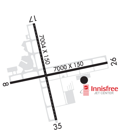
Innisfree Jet Center is a beautiful state of the art facility backed by good old southern hospitality. We offer competitive fuel pricing. All line personnel are NATA safety 1st trained. Fuel volume discounts. Contract fuel available.
Ph: 850-436-4500 Fax: 850-436-6500 Freq: 122.85WebsiteE-Mail
                     
Service
Jet
100LL
SAF
MoGas
Fuel Avail: 0600-2200 every day. PRIST+$0.10/gal
Full7.857.55    Last Update: 04/05/2024 10:35

Self        
Misc. Info: We accept International Garbage.Address: 4343 JERRY L MAYGARDEN RD   PENSACOLA, FL 32504

PENSACOLA AVIA.Ph: 850-434-0636 Fax: 850-472-0391 Freq: 122.95
Service
Jet
100LL
SAF
MoGas
Fuel Avail: Unlimited, PRIST +.$0.10/gal
Full7.657.35    Last Update: 04/05/2024 10:35  
Self        
 Address: 4145 JERRY L. MAYGARDEN ROAD   PENSACOLA, FL 32504
ASOSPh: 850-436-4799
-
Freq: 121.25  
If you are an FBO, call 1-203-262-1700 to update your info or email: FltPlan.Advertising@garmin.com
Advertise your FBO on FltPlan.com

Runway & Approach Info for KPNS
Rwy
Length
Land Dist**
Approach*
  Rwy
Length
Land Dist**
Approach*
08
7000x150  7000'          
 
  
26
  7000x150  7000'          
LOC/DME
 110.95 - 260°  
17
7004x150  7004'          
ILS/DME
 111.10 - 168°  
  
35
  7004x150  7004'          
 
 * only ILS, LOC, LDA, and SDF approaches to a specific runway are shown
** For any Declared Landing Distance Available, please see A/FD or Approach plates
Runway Weight Capability (lbs.) Help
Runway IDSingle WheelDouble WheelDouble Tandem WheelDual Double Wheel
08/2685,000120,000250,000437,000
17/3585,000120,000247,000461,000
These numbers are Advisory and are not limits.   The Airport Manager should have more accurate Weight Limits
Approach Charts
Approaches    
Current Weather/Notams
Customs Information Send updates to Support@FltPlan.com
Phone 850-433-3205
Fax 850-433-3756

Comments Sun-Sat 0830-1700 *4 hrs advance notice required 8 hrs after hours *Maximum passengers per flight: 10 *Prior approval required (landing rights and overflight). *Call prior to 1600 on preceding weekday. *Weekend arrivals call prior to 1600 on preceding Friday.
Database effective 05/16/2024
Airport Diagram of KPNS
Airport Diagram might not be current.

Facility Name: PENSACOLA INTL
City Name: PENSACOLA
County: ESCAMBIA
State abbrev: FL
State Name: FLORIDA
   
Ownership: PUBLICLY OWNED
Use: OPEN TO THE PUBLIC
Owner's Name: CITY OF PENSACOLA
Address: 2430 AIRPORT BLVD SUITE 225
 PENSACOLA, FL 32504
Owner's Phone: 850-436-5000
  
Manager's Name: MATT COUGHLIN, C.M.
Address: 2430 AIRPORT BLVD SUITE 225
 PENSACOLA, FL 32504
Phone: 850-436-5000
   
FAA Region: SOUTHERN
FAA Field Office: ORL


Sunrise / Sunset times for PENSACOLA INTL

DateSunriseSunset
04/23/24 Tuesday6:1219:22
04/24/24 Wednesday6:1119:23
04/25/24 Thursday6:1019:23
04/26/24 Friday6:0919:24
04/27/24 Saturday6:0819:25
04/28/24 Sunday6:0719:25
04/29/24 Monday6:0619:26
04/30/24 Tuesday6:0519:27
05/01/24 Wednesday6:0519:27
05/02/24 Thursday6:0419:28
05/03/24 Friday6:0319:29
05/04/24 Saturday6:0219:29
05/05/24 Sunday6:0119:30
05/06/24 Monday6:0019:31

Airport Facilities

Airport Attendance ScheduleCONTINUOUS
Airport Status OPERATIONAL (This Status can change at any time - please check NOTAMS)
Airport Lighting ScheduleWHEN ATCT CLSD, ACTVT MALSR RWY 17; TDZ RWY 17; HIRL RWY 17/35, 08/26 - CTAF.
Airport Storage AvailableTie Downs, Hanger
Extra Services AvailableCharter, Flight Instruction, Aircraft Rental, Aircraft Sales
Wind IndicatorYES - (lighted)
Control TowerYES
CTAF Frequency119.900
Unicom Frequency122.950
Rotating Beacon ColorWG
Segmented CircleYES
Landing FeeNO

Airport Inspection Data

Airport InspectedFEDERAL - performed by FAA AIRPORTS FIELD PERSONNEL
Inspection Date03/08/2024

Airport Services

Type of Fuel AvailableGrade 100, Grade 100LL, JET A (freeze point -40C)
Airframe Repair ServiceMAJOR
Power Plant Repair ServiceMAJOR

Geographic Data

LatitudeN3028.4
LongitudeW08711.2 (ESTIMATED)
Arpt Elevation120ft (SURVEYED)
Magnetic Variation02W
3 miles NEof PENSACOLA
Traffic Pattern AltitudeOVHD 1500 FT.
Sectional ChartNEW ORLEANS

Aircraft Data

Operations (Reported)YearlyAvg. Daily
General Aviation Transient 45433124
General Aviation Local 44854123
Air Taxi 1267435
Commerical 2485568
Commuter 00
Military 2928780
Aircraft based on Field
General Aviation Singles 141
General Aviation Multi 10
Jet Aircraft 18
General Aviation Helicopters 3
Military Aircraft 0
Gliders 0
Ultralights 0

FAA Services

FSS on field NO
FSS tie-in GAINESVILLE
FSS Phone 1-800-WX-BRIEF
Who issues Notams PNS
Notam D service at airport YES
ARTCC Name JACKSONVILLE

Federal Status

Airport CertificationAIRPORT RECEIVING SCHEDULED AIR CARRIER SERVICE FROM CARRIERS CERTIFICATED BY THE CIVIL AERONAUTICS BOARD; 24 HR PPR FOR UNSKED ACR OPS MORE THAN 30 PAX SEATS OR UNSKED ACFT MORE THAN 65000 LBS GWT OR WINGSPAN GTR THAN 79 FT - AMGR.
Aircraft Rescue & Firefighting IndexAIRPORT HAS A CERTIFICATE UNDER CFR PART 139
Airport of EntryNo
Custom Landing RightsYES; FLT NTFN SVC (ADCUS) AVBL.
Joint Civil/MilitaryNo
Military Landing rightsYES

Federal Agreements

NATIONAL PLAN OF INTEGRATED AIRPORT SYSTEMS (NPIAS)
GRANT AGREEMENTS UNDER FAAP/ADAP/AIP
SURPLUS PROPERTY AGREEMENT UNDER REGULATION 16-WAA
ASSURANCES PURSUANT TO TITLE VI, CIVIL RIGHTS ACT OF 1964
AGREEMENT UNDER DLAND OR DCLA HAS EXPIRED.

Remarks

BIRDS ON & INVOF ARPT.
TWY C SOUTH OF RWY 8/26, C1, C2, TWY D EAST OF RWY 17/35, D1, D2, D3, D4, & D5 ARE 35 FT WIDE; CLSD TO ACFT WITH A WINGSPAN MORE THAN 79 FT.
RUN-UP PAD FOR PISTON ACFT LCTD ON TWY D BTWN D1 & C; FACE NOSE OF ACFT S; OTR ACFT RUN-UP INFO - AMGR.
CTN: RWY 08 APCHS MAY MISTAKE SAUFLEY FIELD NOLF LCTD 7 MI W FOR PNS.
FOR CD IF UNA TO CTC ON FSS FREQ, CTC PENSACOLA APCH AT 850-266-6884 OR 850-266-6885.
TBJT WITH MAX TKOF WT OVR 75000 LBS EXCT STD NOISE ABATEMENT DEP PROFILE IAW FAA AC 91-53.
FIXED WING VFR DEP PROCD TO ARPT BDRY BFR TURNING UNLESS DRCTD BY ATC.
HEL LNDG - PENSACOLA AVIATION 850-434-0636; HEL PRKG LCTD S OF GEN AVN PRKG RAMP BTW TWY C1 & C2 ON CONC PADS.
RWY 08 PREFERRED DEP RWY.
RWY 26 BLACK HOLE ILLUSION EXISTS DURG NGT APCH.
Airport Communications & Frequencies:
ATIS Frequencies:   Hours(local) of Operation: CONTINUOUS
121.25
PENSACOLA Tower Frequencies:   Hours(local) of operation: 0530-2300   
119.9
257.8
PENSACOLA Ground Frequencies:
121.9
348.6
Clearance Delivery Frequencies:
123.725
256.875
348.6
348.6
Pre-Taxi Clearance Frequencies:
348.6
Emergency Frequencies:
121.5
243.0
CTAF Frequency:
119.900
Unicom Frequency:
122.950
Remarks
  • TA35 LLWAS UNMON 2300-0530.
  • PENSACOLA Primary Approach Frequencies:  
    360.725
    118.6 251-339
    119.0 340-159
    269.375 340-159
    351.825 251-339
    360.725
    Part-time Approach Frequencies:  
    124.05
    132.1
    PENSACOLA Primary Departure Frequencies:  
    360.725
    118.6 251-339
    119.0 340-159
    125.35
    269.375 340-159
    351.825 251-339
    360.725
    Part-time Departure Frequencies:  
    124.05
    132.1
    Class C Frequencies:
    118.6 251-339
    119.0 340-159
    120.65 160-250
    269.375 340-159
    270.8 160-250
    351.825 251-339
    Runway Identifications
    Runway Identification: 08/26
    Length: 7000 ft
    Width: 150 ft
    Surface: ASPHALT-FAIR CONDITION
    Edge lights: High Intensity

    Treatment: GROOVED
    Weight: PCN 65 /F/B/W/T

     Runway: 08   Runway: 26
    Mag heading: 80°Mag heading: 260°
    Rwy Slope: .23% UpRwy Slope: -.23% Down
    Approach: Approach: LOC/DME
    Pattern: Left TrafficPattern: Left Traffic
    Markings: PRECISION INSTRUMENTMarkings: PRECISION INSTRUMENT
    Marking Condition: FAIRMarking Condition: FAIR
    Arresting Dev: Arresting Dev:
    Lat & Long: N3028.3  W08711.8Lat. & Long.: N3028.5  W08710.5
    Elev: 97.1 ft. MSLElev: 113.4 ft. MSL
    TCH: 55 ft. AGLTCH: 55 ft. AGL
    Visual Glide Path: 3.00 degreesVisual Glide Path: 3.00 degrees
    Displaced Threshold: NoDisplaced Threshold: No
    Touchdown Zone: YESTouchdown Zone: YES
    Touchdown Elev.: 97.1 feetTouchdown Elev.: 113.4 feet
    Visual Glide Slope: 4-Light PAPI on LEFT side of RunwayVisual Glide Slope: 4-Light PAPI on LEFT side of Runway
    RVR Equipment: RVR Equipment:
    RVV Equipment: NORVV Equipment: NO
    Approach Lights: Approach Lights:
    REIL: YESREIL: YES
    Centerline Lights: NOCenterline Lights: NO
    Touchdown lights: NOTouchdown lights: NO
    Runway Category: Runway with a Non-precision Approach having visibility minimums greater than 3/4 mileRunway Category: D
    Declared Distances: Declared Distances:
    Obstructions: TREESObstructions: TREES
    Marked: NOT Marked/LightedMarked: NOT Marked/Lighted
    Clearance slope: 40:1Clearance slope: 34:1
    Obstruction height: 29 feet AGLObstruction height: 43 feet AGL
    Dist. from runway: 1365 feetDist. from runway: 1690 feet
    Centerline offset: 410 right of centerlineCenterline offset: 355 feet left of centerline
    Comments: 405 FT TREES R OF CNTRLN 200 FT BFR AER.Comments:
    Runway Identification: 17/35
    Length: 7004 ft
    Width: 150 ft
    Surface: CONCRETE-GOOD CONDITION
    Edge lights: High Intensity

    Treatment: GROOVED
    Weight: PCN 74 /R/B/W/T

     Runway: 17   Runway: 35
    Mag heading: 169°Mag heading: 349°
    Rwy Slope: -.26% DownRwy Slope: .26% Up
    Approach: ILS/DMEApproach:
    Pattern: Left TrafficPattern: Left Traffic
    Markings: PRECISION INSTRUMENTMarkings: PRECISION INSTRUMENT
    Marking Condition: GOODMarking Condition: GOOD
    Arresting Dev: Arresting Dev:
    Lat & Long: N3029.0  W08711.4Lat. & Long.: N3027.8  W08711.1
    Elev: 120.9 ft. MSLElev: 102.7 ft. MSL
    TCH: 47 ft. AGLTCH: 55 ft. AGL
    Visual Glide Path: 3.00 degreesVisual Glide Path: 3.00 degrees
    Displaced Threshold: NoDisplaced Threshold: No
    Touchdown Zone: YESTouchdown Zone: YES
    Touchdown Elev.: 120.9 feetTouchdown Elev.: 102.7 feet
    Visual Glide Slope: 4-Light PAPI on LEFT side of RunwayVisual Glide Slope: 4-Light PAPI on LEFT side of Runway
    RVR Equipment: TOUCHDOWNRVR Equipment: TOUCHDOWN
    RVV Equipment: NORVV Equipment: NO
    Approach Lights: MALSR - 1,400 foot medium intensity approach lighting system with runway alignment indicator lightsApproach Lights:
    REIL: NOREIL: YES
    Centerline Lights: YESCenterline Lights: YES
    Touchdown lights: YESTouchdown lights: NO
    Runway Category: Precision Instrument RunwayRunway Category: Runway with a Non-precision Approach having visibility minimums greater than 3/4 mile
    Declared Distances: Declared Distances:
    Obstructions: PLINE; 4275 FT TWR 900 FT L EL 204.Obstructions:
    Marked: NOT Marked/LightedMarked:
    Clearance slope: 48:1Clearance slope: 50:1
    Obstruction height: 86 feet AGLObstruction height:
    Dist. from runway: 4390 feetDist. from runway:
    Centerline offset: 500 left of centerlineCenterline offset:
    Comments: Comments:
    C:103/P: