Current Weather/Notams (Metars, TAFs, Notams, NWS Forecast, PIREPS, and nearby weather)
Customs Information Send updates to Support@FltPlan.com
Phone 207-454-3690
Fax 207-454-7122
Comments Mon-Sat 0800-1700 *3 hr advance notice required *Maximum passengers per flight: 10
Database effective 05/16/2024
Airport Diagram might not be current.
|
| Facility Name: | PRINCETON MUNI |
| City Name: | PRINCETON |
| County: | WASHINGTON |
| State abbrev: | ME |
| State Name: | MAINE |
| | |
| Ownership: | PUBLICLY OWNED |
| Use: | OPEN TO THE PUBLIC |
| Owner's Name: | TOWN OF PRINCETON |
| Address: | TOWN OFFICES |
| | PRINCETON, ME 04668 |
| Owner's Phone: | 207-796-2744 |
| | |
| Manager's Name: | BRAD RICHARD |
| Address: | PO BOX 346 |
| | PRINCETON, ME 04668 |
| Phone: | 207-214-5144 |
| | |
| FAA Region: | NEW ENGLAND |
| FAA Field Office: | NONE |
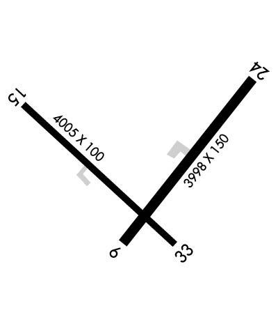
Runway Identifications
Runway Identification: 06/24Length: 3998 ft
Width: 150 ft
Surface: ASPHALT
Edge lights: Treatment: NONE
| | Runway: 06 | | Runway: 24 |
| Mag heading: | 56° | Mag heading: | 236° |
| Rwy Slope: | .17% Up | Rwy Slope: | -.17% Down |
| Approach: | | Approach: | |
| Pattern: | Left Traffic | Pattern: | Left Traffic |
| Markings: | NUMBERS ONLY | Markings: | NUMBERS ONLY |
| Marking Condition: | POOR; RWY 06/24 MKD WITH YELLOW CLOSURE AT BOTH ENDS & MID OF RWY. DTHR MARKINGS ARE NOT VSB. | Marking Condition: | POOR |
| Arresting Dev: | | Arresting Dev: | |
| Lat & Long: | N4511.8 W06734.0 | Lat. & Long.: | N4512.3 W06733.4 |
| Elev: | 238.6 ft. MSL | Elev: | 245.5 ft. MSL |
| TCH: | | TCH: | |
| Visual Glide Path: | | Visual Glide Path: | |
| Displaced Threshold: | No | Displaced Threshold: | 503 feet |
| Touchdown Zone: | YES | Touchdown Zone: | YES |
| Touchdown Elev.: | 249.7 feet | Touchdown Elev.: | 249.7 feet |
| Visual Glide Slope: | | Visual Glide Slope: | |
| RVR Equipment: | | RVR Equipment: | |
| RVV Equipment: | NO | RVV Equipment: | NO |
| Approach Lights: | | Approach Lights: | |
| REIL: | NO | REIL: | NO |
| Centerline Lights: | NO | Centerline Lights: | NO |
| Touchdown lights: | NO | Touchdown lights: | NO |
| Runway Category: | Runway with a Visual Approach | Runway Category: | Runway with a Visual Approach |
| Declared Distances: | | Declared Distances: | |
| Obstructions: | TREES | Obstructions: | TREES |
| Marked: | NOT Marked/Lighted | Marked: | NOT Marked/Lighted |
| Clearance slope: | | Clearance slope: | DTHR NO LONGER VSB. |
| Obstruction height: | 25 feet AGL | Obstruction height: | 25 feet AGL |
| Dist. from runway: | 201 feet | Dist. from runway: | 201 feet |
| Centerline offset: | | Centerline offset: | |
| Comments: | | Comments: | 20-35 FT TREES 20 FT FM THR, 125 FT L & R ACRS APCH. |
Runway Identification: 15/33Length: 4007 ft
Width: 75 ft
Surface: ASPHALT
Edge lights: Medium IntensityTreatment: NONE
| | Runway: 15 | | Runway: 33 |
| Mag heading: | 150° | Mag heading: | 330° |
| Rwy Slope: | -.28% Down | Rwy Slope: | .28% Up |
| Approach: | | Approach: | |
| Pattern: | Left Traffic | Pattern: | Left Traffic |
| Markings: | NONPRECISION INSTRUMENT | Markings: | NONPRECISION INSTRUMENT |
| Marking Condition: | FAIR | Marking Condition: | FAIR |
| Arresting Dev: | | Arresting Dev: | |
| Lat & Long: | N4512.2 W06734.4 | Lat. & Long.: | N4511.8 W06733.7 |
| Elev: | 263.4 ft. MSL | Elev: | 252.3 ft. MSL |
| TCH: | 44 ft. AGL | TCH: | |
| Visual Glide Path: | 3.50 degrees | Visual Glide Path: | |
| Displaced Threshold: | No | Displaced Threshold: | No |
| Touchdown Zone: | YES | Touchdown Zone: | YES |
| Touchdown Elev.: | 264.9 feet | Touchdown Elev.: | 264.9 feet |
| Visual Glide Slope: | 4-Light PAPI on LEFT side of Runway | Visual Glide Slope: | |
| RVR Equipment: | | RVR Equipment: | |
| RVV Equipment: | NO | RVV Equipment: | NO |
| Approach Lights: | | Approach Lights: | |
| REIL: | NO | REIL: | NO |
| Centerline Lights: | NO | Centerline Lights: | NO |
| Touchdown lights: | NO | Touchdown lights: | NO |
| Runway Category: | Runway with a Non-precision Approach | Runway Category: | Runway with a Non-precision Approach |
| Declared Distances: | | Declared Distances: | |
| Obstructions: | TREE | Obstructions: | |
| Marked: | NOT Marked/Lighted | Marked: | |
| Clearance slope: | 8:1 | Clearance slope: | 20:1 |
| Obstruction height: | 3 feet AGL | Obstruction height: | |
| Dist. from runway: | 226 feet | Dist. from runway: | |
| Centerline offset: | 91 left of centerline | Centerline offset: | |
| Comments: | BRUSH 100-200 FT L AND 75-170 FT R OF RWY. | Comments: | |

