Click here for more info on on SMS!

KPLU

PIERCE COUNTY - THUN FIELD
PUYALLUP
WA
Time Zone: Pacific
Lat: N 4706.2
Long: W 12217.2
Elev: 538
Var: -15
Longest Runway: 3651
Clr Del: 121.85
AWOS: 128.57
CTAF: 122.7

FBO & Flight Services info for KPLU

FBOs: Update your Fuel Prices
Located in Pierce County, Thun Field offers spectacular scenery from both the ground and the air. Pilots and aviation enthusiasts alike appreciate the location, the facilities, and the beautiful views of Thun Field.
Ph: 253-798-3779
-
-
WebsiteE-Mail
Service
Jet
100LL
SAF
MoGas
Full        Last Update: 03/19/2024 14:13

Self  6.19    
Misc. Info: Address: 930 TACOMA AVE S   , TACOMA, WA 98402

SIM FLIGHT CTRPh: 253-840-5758 Fax: 253-840-5843 Freq: 122.7

SPANAFLIGHT AVPh: 253-848-2020
-
-

AWOSPh: 253-848-2748
-
Freq: 128.57  
If you are an FBO, call 1-203-262-1700 to update your info or email: FltPlan.Advertising@garmin.com
Advertise your FBO on FltPlan.com

Runway & Approach Info for KPLU
Rwy
Length
Land Dist**
Approach*
  Rwy
Length
Land Dist**
Approach*
17
3651x60  3651'          
 
  
35
  3651x60  3651'          
 
 * only ILS, LOC, LDA, and SDF approaches to a specific runway are shown
** For any Declared Landing Distance Available, please see A/FD or Approach plates
Runway Weight Capability (lbs.) Help
Runway IDSingle WheelDouble WheelDouble Tandem WheelDual Double Wheel
17/35N/AN/AN/AN/A
These numbers are Advisory and are not limits.   The Airport Manager should have more accurate Weight Limits
Approach Charts
Approaches    
Current Weather/Notams
Customs Information Send updates to Support@FltPlan.com
Customs Not Available
Database effective 04/18/2024
Airport Diagram of KPLU
Airport Diagram might not be current.

Facility Name: PIERCE COUNTY - THUN FLD
City Name: PUYALLUP
County: PIERCE
State abbrev: WA
State Name: WASHINGTON
   
Ownership: PUBLICLY OWNED
Use: OPEN TO THE PUBLIC
Owner's Name: PIERCE COUNTY
Address: 9850 - 64TH ST. W.
 UNIVERSITY PLACE, WA 98467
Owner's Phone: 253-798-2421
  
Manager's Name: ROD PROPST
Address: 16915 103RD AVE E
 PUYALLUP, WA 98374-3768
Phone: 253-798-3779
   
FAA Region: NORTHWEST MOUNTAIN
FAA Field Office: SEA


Sunrise / Sunset times for PIERCE COUNTY - THUN FLD

DateSunriseSunset
04/17/24 Wednesday6:1620:02
04/18/24 Thursday6:1420:03
04/19/24 Friday6:1220:05
04/20/24 Saturday6:1020:06
04/21/24 Sunday6:0920:07
04/22/24 Monday6:0720:09
04/23/24 Tuesday6:0520:10
04/24/24 Wednesday6:0320:12
04/25/24 Thursday6:0220:13
04/26/24 Friday6:0020:14
04/27/24 Saturday5:5820:16
04/28/24 Sunday5:5720:17
04/29/24 Monday5:5520:18
04/30/24 Tuesday5:5320:20

Airport Facilities

Airport Attendance Schedule7 Days A Week 0800-1400
Airport Status OPERATIONAL (This Status can change at any time - please check NOTAMS)
Airport Lighting ScheduleACTVT REIL RWYS 17 & 35; PAPI RWYS 17 & 35 AND MIRL RWY 17/35 -CTAF.
Airport Storage AvailableTie Downs
Extra Services AvailableAvionics, Flight Instruction, Aircraft Rental
Wind IndicatorYES - (lighted)
Control TowerNO
CTAF Frequency122.700
Unicom Frequency122.700
Rotating Beacon ColorWG
Segmented CircleYES
Landing FeeNO

Airport Inspection Data

Airport InspectedSTATE - performed by STATE AERONAUTICAL PERSONNEL
Inspection Date06/12/2023

Airport Services

Type of Fuel AvailableGrade 100LL; -10FUEL AVBL 24 HOURS WITH CREDIT CARD.
Airframe Repair ServiceMAJOR
Power Plant Repair ServiceMAJOR

Geographic Data

LatitudeN4706.2
LongitudeW12217.2 (ESTIMATED)
Arpt Elevation537ft (SURVEYED)
Magnetic Variation15E
5 miles Sof PUYALLUP
Traffic Pattern Altitude
Sectional ChartSEATTLE

Aircraft Data

Operations (Reported)YearlyAvg. Daily
General Aviation Transient 69463190
General Aviation Local 3414994
Air Taxi 33889
Commerical 00
Commuter 00
Military 00
Aircraft based on Field
General Aviation Singles 194
General Aviation Multi 9
Jet Aircraft 0
General Aviation Helicopters 2
Military Aircraft 0
Gliders 0
Ultralights 0

FAA Services

FSS on field NO
FSS tie-in SEATTLE
FSS Phone 1-800-WX-BRIEF
Who issues Notams PLU
Notam D service at airport YES
ARTCC Name SEATTLE

Federal Status

Airport Certification
Aircraft Rescue & Firefighting IndexNone
Airport of EntryNo
Custom Landing RightsNo
Joint Civil/MilitaryNo
Military Landing rightsYES

Federal Agreements

NATIONAL PLAN OF INTEGRATED AIRPORT SYSTEMS (NPIAS)
GRANT AGREEMENTS UNDER FAAP/ADAP/AIP
ASSURANCES PURSUANT TO TITLE VI, CIVIL RIGHTS ACT OF 1964

Remarks

ULTRALIGHTS PROHIBITED.
NOISE SENSITIVE ALL QUADRANTS.
FOR CD CTC SEATTLE APCH AT 206-214-4723.
Airport Communications & Frequencies:
Clearance Delivery Frequencies:
121.85
CTAF Frequency:
122.700
Unicom Frequency:
122.700
SEATTLE Primary Approach Frequencies:  
126.5
377.15
SEATTLE Primary Departure Frequencies:  
126.5
377.15
Runway Identifications
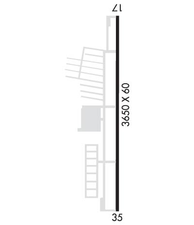
Runway Identification: 17/35
Length: 3651 ft
Width: 60 ft
Surface: ASPHALT-GOOD CONDITION
Edge lights: Medium Intensity

Treatment: NONE

 Runway: 17   Runway: 35
Mag heading: 165°Mag heading: 345°
Rwy Slope: -.05% DownRwy Slope: .05% Up
Approach: Approach:
Pattern: Left TrafficPattern: Left Traffic
Markings: NONPRECISION INSTRUMENTMarkings: NONPRECISION INSTRUMENT
Marking Condition: GOODMarking Condition: GOOD
Arresting Dev: Arresting Dev:
Lat & Long: N4706.5  W12217.2Lat. & Long.: N4705.9  W12217.2
Elev: 537.4 ft. MSLElev: 535.4 ft. MSL
TCH: 53 ft. AGLTCH: 53 ft. AGL
Visual Glide Path: 4.00 degreesVisual Glide Path: 4.00 degrees
Displaced Threshold: NoDisplaced Threshold: No
Touchdown Zone: YESTouchdown Zone: YES
Touchdown Elev.: 537.6 feetTouchdown Elev.: 537.6 feet
Visual Glide Slope: 4-Light PAPI on LEFT side of RunwayVisual Glide Slope: 4-Light PAPI on RIGHT side of Runway
RVR Equipment: RVR Equipment:
RVV Equipment: NORVV Equipment: NO
Approach Lights: Approach Lights:
REIL: YESREIL: YES
Centerline Lights: NOCenterline Lights: NO
Touchdown lights: NOTouchdown lights: NO
Runway Category: Runway with a Visual ApproachRunway Category: Runway with a Non-precision Approach
Declared Distances: Declared Distances:
Obstructions: TREESObstructions: ROAD
Marked: NOT Marked/LightedMarked: NOT Marked/Lighted
Clearance slope: 34:1Clearance slope: 3:1
Obstruction height: 75 feet AGLObstruction height: 13 feet AGL
Dist. from runway: 2800 feetDist. from runway: 242 feet
Centerline offset: Centerline offset: B
Comments: Comments:
C:2/P: