Current Weather/Notams (Metars, TAFs, Notams, NWS Forecast, PIREPS, and nearby weather)
Customs Information Send updates to Support@FltPlan.com
Customs Not Available
Database effective 05/16/2024
Airport Diagram might not be current.
|
| Facility Name: | ST CLAIR COUNTY |
| City Name: | PELL CITY |
| County: | ST CLAIR |
| State abbrev: | AL |
| State Name: | ALABAMA |
| | |
| Ownership: | PUBLICLY OWNED |
| Use: | OPEN TO THE PUBLIC |
| Owner's Name: | ST CLAIR CO ARPT AUTH; CONTACT PERSON: ERSKINE FUNDERBURG; CHAIRMAN ST. CLAIR COUNTY ARPT AUTHORITY. |
| Address: | 240 AIRPORT ROAD |
| | PELL CITY, AL 35128 |
| Owner's Phone: | 205-338-9456 |
| | |
| Manager's Name: | WENDY WATSON |
| Address: | 240 AIRPORT ROAD |
| | PELL CITY, AL 35128 |
| Phone: | 205-338-9456 |
| | |
| FAA Region: | SOUTHERN |
| FAA Field Office: | JAN |
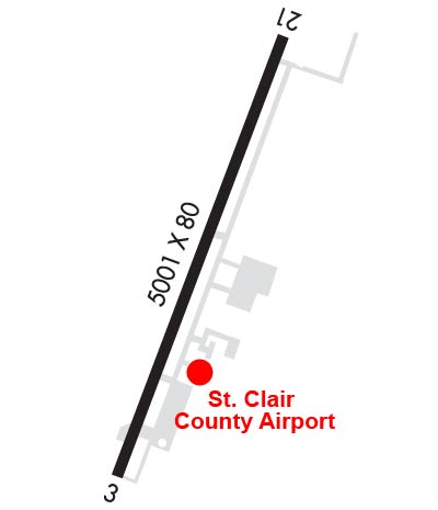
Runway Identifications
Runway Identification: 03/21Length: 5001 ft
Width: 80 ft
Surface: ASPHALT-GOOD CONDITION
Edge lights: Medium IntensityTreatment: NONE
| | Runway: 03 | | Runway: 21 |
| Mag heading: | 26° | Mag heading: | 206° |
| Rwy Slope: | -.02% Down | Rwy Slope: | .02% Up |
| Approach: | | Approach: | |
| Pattern: | Left Traffic | Pattern: | Left Traffic |
| Markings: | NONPRECISION INSTRUMENT | Markings: | NONPRECISION INSTRUMENT |
| Marking Condition: | GOOD | Marking Condition: | GOOD |
| Arresting Dev: | | Arresting Dev: | |
| Lat & Long: | N3333.1 W08615.1 | Lat. & Long.: | N3333.9 W08614.8 |
| Elev: | 483.2 ft. MSL | Elev: | 482.4 ft. MSL |
| TCH: | 46 ft. AGL | TCH: | 53 ft. AGL |
| Visual Glide Path: | 3.00 degrees | Visual Glide Path: | 3.00 degrees |
| Displaced Threshold: | 230 feet | Displaced Threshold: | No |
| Touchdown Zone: | YES | Touchdown Zone: | YES |
| Touchdown Elev.: | 483.5 feet | Touchdown Elev.: | 484.7 feet |
| Visual Glide Slope: | 4-Light PAPI on LEFT side of Runway | Visual Glide Slope: | 4-Light PAPI on LEFT side of Runway |
| RVR Equipment: | | RVR Equipment: | |
| RVV Equipment: | NO | RVV Equipment: | NO |
| Approach Lights: | | Approach Lights: | |
| REIL: | NO | REIL: | NO |
| Centerline Lights: | NO | Centerline Lights: | NO |
| Touchdown lights: | NO | Touchdown lights: | NO |
| Runway Category: | Runway with a Non-precision Approach having visibility minimums greater than 3/4 mile | Runway Category: | Runway with a Non-precision Approach having visibility minimums greater than 3/4 mile |
| Declared Distances: | | Declared Distances: | |
| Obstructions: | ROAD | Obstructions: | TREE |
| Marked: | NOT Marked/Lighted | Marked: | NOT Marked/Lighted |
| Clearance slope: | 10:1; RWY 03 APCH RATIO 24:1 TO DSPLCD THLD. | Clearance slope: | 21:1 |
| Obstruction height: | 18 feet AGL | Obstruction height: | 26 feet AGL |
| Dist. from runway: | 397 feet | Dist. from runway: | 753 feet |
| Centerline offset: | | Centerline offset: | 246 feet right of centerline |
| Comments: | | Comments: | |