
| ||||||||||||||||||||||||||||||||||||||||||||||||||||||||||||||||||||
| ||||||||||||||||||||||||||||||||||||||||||||||||||||||||||||||||||||
| Rwy | Rwy | |||||||
| 3738x100 | 3449' | 3738x100 | 3428' | |||||
| Runway ID | Single Wheel | Double Wheel | Double Tandem Wheel | Dual Double Wheel |
| 12/30 | 70,000 | 100,000 | N/A | N/A |
| These numbers are Advisory and are not limits. The Airport Manager should have more accurate Weight Limits | ||||
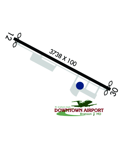 Airport Diagram might not be current. | |
| Facility Name: | M GRAHAM CLARK DOWNTOWN |
| City Name: | BRANSON |
| County: | TANEY |
| State abbrev: | MO |
| State Name: | MISSOURI |
| Ownership: | PUBLICLY OWNED |
| Use: | OPEN TO THE PUBLIC |
| Owner's Name: | TANEY COUNTY MISSOURI |
| Address: | PO BOX 1086 |
| FORSYTH, MO 65653 | |
| Owner's Phone: | 417-546-7200 |
| Manager's Name: | MIKE MULNIK |
| Address: | PO BOX 1194 |
| BRANSON, MO 65616 | |
| Phone: | 417-332-1848; 417-677-5300. |
| FAA Region: | CENTRAL |
| FAA Field Office: | NONE |
| Date | Sunrise | Sunset |
|---|---|---|
| 04/18/24 Thursday | 6:34 | 19:51 |
| 04/19/24 Friday | 6:33 | 19:51 |
| 04/20/24 Saturday | 6:32 | 19:52 |
| 04/21/24 Sunday | 6:30 | 19:53 |
| 04/22/24 Monday | 6:29 | 19:54 |
| 04/23/24 Tuesday | 6:28 | 19:55 |
| 04/24/24 Wednesday | 6:27 | 19:56 |
| 04/25/24 Thursday | 6:25 | 19:57 |
| 04/26/24 Friday | 6:24 | 19:58 |
| 04/27/24 Saturday | 6:23 | 19:58 |
| 04/28/24 Sunday | 6:22 | 19:59 |
| 04/29/24 Monday | 6:21 | 20:00 |
| 04/30/24 Tuesday | 6:19 | 20:01 |
| 05/01/24 Wednesday | 6:18 | 20:02 |
| Airport Attendance Schedule | 7 Days A Week 0700-1700 |
| Airport Status | OPERATIONAL (This Status can change at any time - please check NOTAMS) |
| Airport Lighting Schedule | ACTVT REIL RWY 12 & 30; VASI RWY 30; MIRL RWY 12/30 - CTAF. |
| Airport Storage Available | Tie Downs, Hanger |
| Extra Services Available | Air Ambulance, Flight Instruction, Aircraft Rental |
| Wind Indicator | YES - (lighted) |
| Control Tower | NO |
| CTAF Frequency | 122.700 |
| Unicom Frequency | 122.700 |
| Rotating Beacon Color | WG |
| Segmented Circle | YES |
| Landing Fee | NO |
| Airport Inspected | STATE - performed by STATE AERONAUTICAL PERSONNEL |
| Inspection Date | 07/22/2021 |
| Type of Fuel Available | Grade 100LL, JET A |
| Airframe Repair Service | MINOR |
| Power Plant Repair Service | MINOR |
| Latitude | N3637.6 |
| Longitude | W09313.7 (ESTIMATED) |
| Arpt Elevation | 940ft (SURVEYED) |
| Magnetic Variation | 02E |
| 1 miles S | of BRANSON |
| Traffic Pattern Altitude | |
| Sectional Chart | KANSAS CITY |
| Operations (Reported) | Yearly | Avg. Daily |
|---|---|---|
| General Aviation Transient | 8200 | 22 |
| General Aviation Local | 7100 | 19 |
| Air Taxi | 620 | 2 |
| Commerical | 0 | 0 |
| Commuter | 0 | 0 |
| Military | 80 | 0 |
| Aircraft based on Field | |
|---|---|
| General Aviation Singles | 39 |
| General Aviation Multi | 7 |
| Jet Aircraft | 2 |
| General Aviation Helicopters | 4 |
| Military Aircraft | 0 |
| Gliders | 0 |
| Ultralights | 0 |
| FSS on field | NO |
| FSS tie-in | COLUMBIA |
| FSS Phone | 1-800-WX-BRIEF |
| Who issues Notams | COU |
| Notam D service at airport | YES |
| ARTCC Name | MEMPHIS |
| Airport Certification | |
| Aircraft Rescue & Firefighting Index | None |
| Airport of Entry | No |
| Custom Landing Rights | No |
| Joint Civil/Military | No |
| Military Landing rights | No |
| NO SAFETY/OVERRUN AREAS AT RY ENDS-LARGE DROP-OFFS. STEEP TERRAIN GRADIENTS ALONG RY PVMT EDGES. |
| GA SVCS AVBL EAST END OF AIRFIELD. |
| STUDENT TRAINING ACTIVITIES IN THE AREA. |
| DEER ON & INVOF ARPT. |
| BRANSON ARPT ATTRACTIONS NEAR ARPTS. |
| FOR CD CTC SPRINGFIELD APCH AT 417-868-5620/5619. |
Airport Communications & Frequencies:
|
| Runway: 12 | Runway: 30 | ||
| Mag heading: | 117° | Mag heading: | 297° |
| Rwy Slope: | -.22% Down | Rwy Slope: | .22% Up |
| Approach: | Approach: | ||
| Pattern: | Left Traffic | Pattern: | Left Traffic |
| Markings: | NONPRECISION INSTRUMENT | Markings: | NONPRECISION INSTRUMENT |
| Marking Condition: | GOOD | Marking Condition: | GOOD |
| Arresting Dev: | Arresting Dev: | ||
| Lat & Long: | N3637.7 W09314.1 | Lat. & Long.: | N3637.4 W09313.4 |
| Elev: | 939.8 ft. MSL | Elev: | 931.7 ft. MSL |
| TCH: | TCH: | 52 ft. AGL | |
| Visual Glide Path: | Visual Glide Path: | 3.00 degrees | |
| Displaced Threshold: | 289 feet | Displaced Threshold: | 310 feet |
| Touchdown Zone: | YES | Touchdown Zone: | YES |
| Touchdown Elev.: | 940.1 feet | Touchdown Elev.: | 938.8 feet |
| Visual Glide Slope: | Visual Glide Slope: | 4-BOX VASI ON RIGHT SIDE OF RUNWAY | |
| RVR Equipment: | RVR Equipment: | ||
| RVV Equipment: | NO | RVV Equipment: | NO |
| Approach Lights: | Approach Lights: | ||
| REIL: | YES; RWY 12 REIL LOCATED 105 FT FROM DTHR. | REIL: | YES; RWY 30 REIL LOCATED 86 FT FROM DTHR. |
| Centerline Lights: | NO | Centerline Lights: | NO |
| Touchdown lights: | NO | Touchdown lights: | NO |
| Runway Category: | Runway with a Non-precision Approach having visibility minimums greater than 3/4 mile | Runway Category: | Runway with a Non-precision Approach having visibility minimums greater than 3/4 mile |
| Declared Distances: | Declared Distances: |


