Click here for more info on on SMS!

KPJC

ZELIENOPLE MUNI
ZELIENOPLE
PA
Time Zone: Eastern
Lat: N 4048.1
Long: W 08009.7
Elev: 898
Var: +09
Longest Runway: 4933
CTAF: 122.9

FBO & Flight Services info for KPJC

FBOs: Update your Fuel Prices

  click here  
Convenient Location. Easy Access to Downtown Pittsburgh. Great Alternative to PIT or AGC. Quick Turns, Pilot Lounge, Passenger Terminal, Hangar Space, Ramp Parking, Tie-down Parking, Crew Cars, Rental Cars On Site, Courtesy Transportation, Internet Access, Hotel Reservations, Catering, Oxygen, Lav Service, Deicing, GPU, Aircraft Cleaning and Maintenance.
Ph: 724-452-4719 Fax: 724-453-1908 Freq: 122.9WebsiteE-Mail
                   
Service
Jet
100LL
SAF
MoGas
Fuel Avail: 100LL and Jet A self-serve available 24/7. Jet A full-service available during business hours.
Full5.20      Last Update: 04/18/2024 20:59
PRICES GUARANTEED by FBO.
Self5.206.60    
Misc. Info: Business hours: Mon-Fri 06:00-23:00. After hours available 24/7 with surcharge.Address: 1859 ROUTE 588   ZELIENOPLE, PA 16063

ASOSPh: 724-452-5304
-
Freq: 118.45  
If you are an FBO, call 1-203-262-1700 to update your info or email: FltPlan.Advertising@garmin.com
Advertise your FBO on FltPlan.com

Runway & Approach Info for KPJC
Rwy
Length
Land Dist**
Approach*
  Rwy
Length
Land Dist**
Approach*
17
4933x75  4382'          
 
  
35
  4933x75  4651'          
 
 * only ILS, LOC, LDA, and SDF approaches to a specific runway are shown
** For any Declared Landing Distance Available, please see A/FD or Approach plates
Runway Weight Capability (lbs.) Help
Runway IDSingle WheelDouble WheelDouble Tandem WheelDual Double Wheel
17/35N/AN/AN/AN/A
These numbers are Advisory and are not limits.   The Airport Manager should have more accurate Weight Limits
Approach Charts
Approaches    
Current Weather/Notams
Customs Information Send updates to Support@FltPlan.com
Customs Not Available
Database effective 05/16/2024
Airport Diagram of KPJC
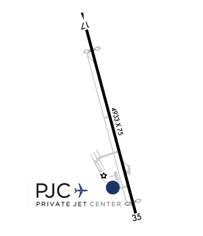
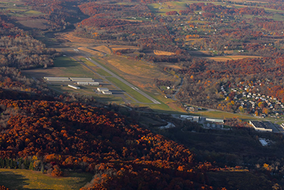
Airport Diagram might not be current.

Facility Name: ZELIENOPLE MUNI
City Name: ZELIENOPLE
County: BEAVER
State abbrev: PA
State Name: PENNSYLVANIA
   
Ownership: PUBLICLY OWNED
Use: OPEN TO THE PUBLIC
Owner's Name: ARPT AUTH BORO ZELIENOPLE
Address: 100 TASA DRIVE
 ZELIENOPLE, PA 16063
Owner's Phone: 724-452-1290
  
Manager's Name: DAVE HOLMAN
Address: 220 TASA DRIVE
 ZELIENOPLE, PA 16063
Phone: 724-452-4719
   
FAA Region: EASTERN
FAA Field Office: HAR
Photo courtesy of Frank Pope at PJC, 10/28/22


Click here for full scale & interactive Sectional view of KPJC


Sunrise / Sunset times for ZELIENOPLE MUNI

DateSunriseSunset
04/22/24 Monday6:3020:08
04/23/24 Tuesday6:2920:09
04/24/24 Wednesday6:2720:10
04/25/24 Thursday6:2620:12
04/26/24 Friday6:2520:13
04/27/24 Saturday6:2320:14
04/28/24 Sunday6:2220:15
04/29/24 Monday6:2120:16
04/30/24 Tuesday6:1920:17
05/01/24 Wednesday6:1820:18
05/02/24 Thursday6:1720:19
05/03/24 Friday6:1620:20
05/04/24 Saturday6:1420:21
05/05/24 Sunday6:1320:22

Airport Facilities

Airport Attendance ScheduleMON-FRI 0600-2200, SAT-SUN ON CALL; FOR ATTENDANT SAT-SUN CALL 724-452-4719.
Airport Status OPERATIONAL (This Status can change at any time - please check NOTAMS)
Airport Lighting ScheduleACTVT REIL RWY 17 & 35; MIRL RWY 17/35 AFT 2200 - CTAF. PAPI CONS & MIRL OPER DUSK-2200.
Airport Storage AvailableTie Downs, Hanger
Extra Services AvailableCharter, Flight Instruction
Wind IndicatorYES - (lighted)
Control TowerNO
CTAF Frequency122.900
Unicom Frequency
Rotating Beacon ColorWG
Segmented CircleNO
Landing FeeNO

Airport Inspection Data

Airport InspectedSTATE - performed by STATE AERONAUTICAL PERSONNEL
Inspection Date11/30/2023

Airport Services

Type of Fuel AvailableGrade 100LL, JET A (freeze point -40C), JET A
Airframe Repair ServiceMAJOR
Power Plant Repair ServiceMAJOR

Geographic Data

LatitudeN4048.1
LongitudeW08009.7 (ESTIMATED)
Arpt Elevation897ft (SURVEYED)
Magnetic Variation09W
1 miles Wof ZELIENOPLE
Traffic Pattern Altitude
Sectional ChartDETROIT

Aircraft Data

Operations (Reported)YearlyAvg. Daily
General Aviation Transient 640018
General Aviation Local 3331591
Air Taxi 21006
Commerical 00
Commuter 00
Military 1600
Aircraft based on Field
General Aviation Singles 41
General Aviation Multi 3
Jet Aircraft 3
General Aviation Helicopters 6
Military Aircraft 0
Gliders 0
Ultralights 0

FAA Services

FSS on field NO
FSS tie-in ALTOONA
FSS Phone 1-800-WX-BRIEF
Who issues Notams AOO
Notam D service at airport YES
ARTCC Name CLEVELAND

Federal Status

Airport Certification
Aircraft Rescue & Firefighting IndexNone
Airport of EntryNo
Custom Landing RightsNo
Joint Civil/MilitaryNo
Military Landing rightsNo

Federal Agreements

NATIONAL PLAN OF INTEGRATED AIRPORT SYSTEMS (NPIAS)
GRANT AGREEMENTS UNDER FAAP/ADAP/AIP
ASSURANCES PURSUANT TO TITLE VI, CIVIL RIGHTS ACT OF 1964

Remarks

DEER & GEESE ON & INVOF RWY.
PARALLEL TXY MKD WITH REFLECTORS.
FOR CD CTC PITTSBURGH APCH AT 412-472-5591.
RWY 35 68 FT LGT POLE 720 FT FM THLD, 291 FT RT. 56 FT LGT POLE 480 FT FM THLD, 267 FT LT. POLES LGT FM THE BOTTOM.
Airport Communications & Frequencies:
CTAF Frequency:
122.900
PITTSBURGH Primary Approach Frequencies:  
124.75
338.2
PITTSBURGH Primary Departure Frequencies:  
124.75
338.2
Runway Identifications
Runway Identification: 17/35
Length: 4933 ft
Width: 75 ft
Surface: ASPHALT-GOOD CONDITION
Edge lights: Medium Intensity

Treatment: NONE

 Runway: 17   Runway: 35
Mag heading: 174°Mag heading: 354°
Rwy Slope: .13% UpRwy Slope: -.13% Down
Approach: Approach:
Pattern: Left TrafficPattern: Left Traffic
Markings: NONPRECISION INSTRUMENTMarkings: NONPRECISION INSTRUMENT
Marking Condition: FAIRMarking Condition: GOOD
Arresting Dev: Arresting Dev:
Lat & Long: N4048.5  W08009.8Lat. & Long.: N4047.7  W08009.5
Elev: 889.9 ft. MSLElev: 896.2 ft. MSL
TCH: TCH: 50 ft. AGL
Visual Glide Path: Visual Glide Path: 3.48 degrees
Displaced Threshold: 551 feetDisplaced Threshold: 282 feet
Touchdown Zone: YESTouchdown Zone: YES
Touchdown Elev.: 896.7 feetTouchdown Elev.: 897.8 feet
Visual Glide Slope: Visual Glide Slope: 2-Light PAPI on LEFT side of Runway; PAPI UNUSBL BYD 5 DEG L OF CNTRLN.
RVR Equipment: RVR Equipment:
RVV Equipment: NORVV Equipment: NO
Approach Lights: Approach Lights:
REIL: YESREIL: YES
Centerline Lights: NOCenterline Lights: NO
Touchdown lights: NOTouchdown lights: NO
Runway Category: Runway with a Non-precision Approach having visibility minimums greater than 3/4 mileRunway Category: Runway with a Non-precision Approach having visibility minimums greater than 3/4 mile
Declared Distances: TORA:4932' TODA:4932' ASDA:4932' LDA:4381'Declared Distances: TORA:4932' TODA:4932' ASDA:4932' LDA:4650'
Obstructions: TREESObstructions: POLE
Marked: NOT Marked/LightedMarked: LIGHTED; NON-STD LGTG; UTILITY POLE LIT FROM THE BOTTOM.
Clearance slope: 16:1; RWY 17 108 FT TREES, 1988 FT FM THLD 249 FT RIGHT. 16:1 TO THLD.Clearance slope: 5:1
Obstruction height: 109 feet AGLObstruction height: 56 feet AGL
Dist. from runway: 1988 feetDist. from runway: 480 feet
Centerline offset: 249 left of centerlineCenterline offset: 267 feet left of centerline
Comments: Comments:
C:15/P: