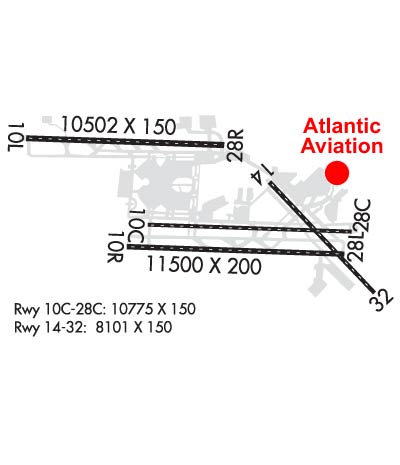
Atlantic Aviation is your premier aviation service provider with more than 100 locations in North America, including Hawaii and the Caribbean. We provide standard ground services you'd expect, with a detailed focus on ensuring an unforgettable customer experience.
Airquest Aviation is the region's premier FBO serving Butler & Beaver counties in the North Pittsburgh area. Our part 145 repair station covers most business jets & turboprop plus single/twin piston AC. Our full service FBO offers personalized service, fuel volume discounts, hangar space -- both heated and temp controlled, and AvTrip points. 24 hour service available upon request.
OPERATIONAL (This Status can change at any time - please check NOTAMS)
Airport Lighting Schedule
Airport Storage Available
Tie Downs, Hanger
Extra Services Available
Air Freight, Cargo Handling
Wind Indicator
YES - (lighted)
Control Tower
YES
CTAF Frequency
Unicom Frequency
122.950
Rotating Beacon Color
WG
Segmented Circle
NO
Landing Fee
YES
Airport Inspection Data
Airport Inspected
FEDERAL - performed by FAA AIRPORTS FIELD PERSONNEL
Inspection Date
03/29/2021
Airport Services
Type of Fuel Available
Grade 100LL, JET A (freeze point -40C); -10LOX SOAP (AVBL DURG ANG DUTY HOURS ONLY. 30 MIN PRIOR NOTICE RQRD.).
Airframe Repair Service
MINOR
Power Plant Repair Service
MINOR
Geographic Data
Latitude
N4029.5
Longitude
W08014.0 (ESTIMATED)
Arpt Elevation
1202ft (SURVEYED)
Magnetic Variation
09W
12 miles NW
of PITTSBURGH
Traffic Pattern Altitude
Sectional Chart
DETROIT
Aircraft Data
Operations (Reported)
Yearly
Avg. Daily
General Aviation Transient
6762
19
General Aviation Local
106
0
Air Taxi
18594
51
Commerical
81202
222
Commuter
0
0
Military
5223
14
Aircraft based on Field
General Aviation Singles
0
General Aviation Multi
0
Jet Aircraft
23
General Aviation Helicopters
0
Military Aircraft
24
Gliders
0
Ultralights
0
FAA Services
FSS on field
NO
FSS tie-in
ALTOONA
FSS Phone
1-800-WX-BRIEF
Who issues Notams
PIT
Notam D service at airport
YES
ARTCC Name
CLEVELAND
Federal Status
Airport Certification
AIRPORT RECEIVING SCHEDULED AIR CARRIER SERVICE FROM CARRIERS CERTIFICATED BY THE CIVIL AERONAUTICS BOARD
Aircraft Rescue & Firefighting Index
AIRPORT HAS A CERTIFICATE UNDER CFR PART 139
Airport of Entry
No
Custom Landing Rights
YES
Joint Civil/Military
No
Military Landing rights
YES
Federal Agreements
NATIONAL PLAN OF INTEGRATED AIRPORT SYSTEMS (NPIAS)
GRANT AGREEMENTS UNDER FAAP/ADAP/AIP
COMPLIANCE WITH ACCESSIBILITY TO THE HANDICAPPED
ASSURANCES PURSUANT TO TITLE VI, CIVIL RIGHTS ACT OF 1964
AGREEMENT UNDER DLAND OR DCLA HAS EXPIRED.
Remarks
DEER & BIRDS ON & INVOF ARPT.
ATCT IS AUTHORIZED TO HAVE ACFT LINE-UP & WAIT ON RYS 28L AT TWY 'P' DURG HRS OF DARKNESS. THE SPECIFIC RY SHALL BE USED ONLY FOR DEPARTURES & THE INTXN MUST BE VSB FM ATCT.
ANG: OPR 1130-2030Z++MON-FRI EXCP HOL. (CLSD EV OTH MON.)
TWY G INTXN AT RY 10L/28R RIGHT TURN NA.
FUEL: A++ PROVIDED BY ANG AND AFRC.(MIL).
ASSC IN USE. OPERATE TRANSPONDERS WITH ALTITUDE REPORTING MODE AND ADS-B (IF EQUIPPED) ENABLED ON ALL AIRPORT SURFACES.
ACFT USING TWY 'N' PROHIBITED TO STOP ON OVERPASS AREA DUE TO POSSIBLE EMERGENCY EVACUATION HAZARD.
PPR/OFFL BUS MIN 48 HR CTC AFLD MGMT DSN 277 8163, C412 474 8163. LTD TRAN SVC. AFLD MGT NML DUTY HRS 1300 0100++ MON, WED, FRI, 1300-0500++ TUE, THU, EXC HOL. UNIT TRAINING ASSEMBLY 1300 2100Z++SAT. TRAN ACFT MUST HAVE APPVL OF 911OG/CC FOR PPR DUR OFF DUTY HR. NO SVC AVBL FOR SPACE AVBL PAX DUR OFF DUTY HR. CALL PITT COMD POST (IRON CITY) BY RDO 15 MIN PRIOR TO ARRIVAL. ALFD MGMT DOES NOT ISSUE OR STOR COMSEC. COMSEC STOR CTC COMD POST DSN 277 8146.
TWY AA NO TURN-OFF ONTO TWY A FOR ACFT WINGSPAN 171 FT OR GREATER EXC PPR (412) 472-5630.
[MILITARY]: CAUTION: BASH PHASE II OPS IN EFFECT 1 JUL - 31 AUG ANNUALLY. UNLESS MSN REQUIREMENTS DIRECT OTHERWISE, FLIGHTS SHOULD NOT BE SKED WITHIN +/-1HR OF SS/SR. TRAN AIRCREW SHOULD REQ BIRD WATCH COND FR AFRC (PITT OPS) ON 252.1 OR ANG OPS (STEEL CTL) ON 311.0. AIRCREW WILL BE INFORMED BY STEEL CONTROL OR PITT OPS (AS APPLICABLE) IF CURRENT BWC IS OTHER THAN LOW REGARDLESS OF BASH PHASE.
TRML APN UNCONTROLLED. PUSHBACK PILOT DESCRETION. DO NOT EXIT TRML APN AT TWY C1, C4, V3, V4, D1, W. CTC GC WHEN HLDG AT TWY C2, C3, V1, V2, V5, V6, D2, D3.
LDG FEE.
PUSHBACK CLNC REQUIRED FR GATES A100 AND A101 AT CARGO A. CTC GC. PUSHBACK FM THESE GATES ENTERS TWY N.
ANG ACFT MUST CTC TANKER 303.0/FTR OPNS 293.7 BEFORE CROSSING RWY 28L TO OBTAIN CLNC TO ENTER.
TERML TAXILANES E OF CONCOURSES A & B RESTRD TO GROUP 3 ACFT & SMALLER.
RWY 10C/ 28CPCR VALUE: 804/R/A/X/T
RWY 10L/ 28RPCR VALUE: 780/R/A/X/T
RWY 10R/ 28LPCR VALUE: 980/R/A/X/T
RWY 14/3 2 PCR VALUE: 835/R/A/X/T
Airport Communications & Frequencies:
ATIS Frequencies: Hours(local) of Operation: CONTINUOUS
127.25 ;ARR
135.9 ;DEP
PITTSBURGH Tower Frequencies: Hours(local) of operation: CONTINUOUS
128.3
291.7
PITTSBURGH Ground Frequencies:
121.9 ;SOUTH
127.8 ;NORTH
348.6
Clearance Delivery Frequencies:
126.75
353.7
Pre-Taxi Clearance Frequencies:
126.75
Emergency Frequencies:
121.5
243.0
Unicom Frequency:
122.950
Remarks
CALL IRON CITY COMMAND POST PRIOR TO ENTRY SOUTH RAMP.
PITTSBURGH Primary Approach Frequencies: Hours(local) of operation: CONTINUOUS
121.25 ;271-360
123.95 ;091-180
124.15 ;001-090
133.7 ;181-270
279.625 ;270-089
336.2
360.8 ;090-269
PITTSBURGH Primary Departure Frequencies: Hours(local) of operation: CONTINUOUS
Length: 10775 ft Width: 150 ft Surface: CONCRETE ASPHALT-FAIR CONDITION Edge lights: High Intensity Treatment: GROOVED
Runway: 10C
Runway: 28C
Mag heading:
101°
Mag heading:
281°
Rwy Slope:
-.03% Down
Rwy Slope:
.03% Up
Approach:
Approach:
Pattern:
Left Traffic
Pattern:
Left Traffic
Markings:
PRECISION INSTRUMENT
Markings:
PRECISION INSTRUMENT
Marking Condition:
GOOD
Marking Condition:
GOOD
Arresting Dev:
Arresting Dev:
Lat & Long:
N4029.4 W08014.9
Lat. & Long.:
N4029.3 W08012.6
Elev:
1140.2 ft. MSL
Elev:
1136.6 ft. MSL
TCH:
50 ft. AGL
TCH:
43 ft. AGL
Visual Glide Path:
3.00 degrees
Visual Glide Path:
3.00 degrees
Displaced Threshold:
465 feet
Displaced Threshold:
602 feet
Touchdown Zone:
YES
Touchdown Zone:
YES
Touchdown Elev.:
1141.4 feet
Touchdown Elev.:
1133.5 feet
Visual Glide Slope:
4-Light PAPI on LEFT side of Runway
Visual Glide Slope:
4-Light PAPI on LEFT side of Runway
RVR Equipment:
TOUCHDOWN-MIDFIELD-ROLLOUT
RVR Equipment:
TOUCHDOWN-MIDFIELD-ROLLOUT
RVV Equipment:
NO
RVV Equipment:
NO
Approach Lights:
Approach Lights:
REIL:
YES
REIL:
NO
Centerline Lights:
YES
Centerline Lights:
YES
Touchdown lights:
NO
Touchdown lights:
YES
Runway Category:
Runway with a Non-precision Approach having visibility minimums greater than 3/4 mile
Runway Category:
Runway with a Non-precision Approach having visibility minimums greater than 3/4 mile
Declared Distances:
TORA:10775' TODA:10775' ASDA:10173' LDA:9708'
Declared Distances:
TORA:10775' TODA:10775' ASDA:10310' LDA:9708'
Runway Identification: 10L/28R
Length: 10502 ft Width: 150 ft Surface: CONCRETE ASPHALT-GOOD CONDITION Edge lights: High Intensity Treatment: GROOVED
Runway: 10L
Runway: 28R
Mag heading:
101°
Mag heading:
281°
Rwy Slope:
-.27% Down
Rwy Slope:
.27% Up
Approach:
ILS
Approach:
ILS
Pattern:
Left Traffic
Pattern:
Left Traffic
Markings:
PRECISION INSTRUMENT
Markings:
PRECISION INSTRUMENT
Marking Condition:
GOOD
Marking Condition:
GOOD
Arresting Dev:
Arresting Dev:
Lat & Long:
N4030.1 W08016.3
Lat. & Long.:
N4030.1 W08014.0
Elev:
1202.9 ft. MSL
Elev:
1174.1 ft. MSL
TCH:
83 ft. AGL
TCH:
71 ft. AGL
Visual Glide Path:
3.00 degrees
Visual Glide Path:
3.00 degrees
Displaced Threshold:
No
Displaced Threshold:
No
Touchdown Zone:
YES
Touchdown Zone:
YES
Touchdown Elev.:
1202.9 feet
Touchdown Elev.:
1174.1 feet
Visual Glide Slope:
4-Light PAPI on LEFT side of Runway
Visual Glide Slope:
4-Light PAPI on LEFT side of Runway
RVR Equipment:
TOUCHDOWN-MIDFIELD-ROLLOUT
RVR Equipment:
TOUCHDOWN-MIDFIELD-ROLLOUT
RVV Equipment:
YES
RVV Equipment:
YES
Approach Lights:
ALSF2 - standard 2,400 foot high intensity approach lighting system with sequenced flashers, Category II or III; ALSF2/SSALR IS A DUAL MODE SYSTEM & CONTROLLED BY ATCT & REMOTE MONITORED.
Approach Lights:
MALSR - 1,400 foot medium intensity approach lighting system with runway alignment indicator lights
REIL:
NO
REIL:
NO
Centerline Lights:
YES
Centerline Lights:
YES
Touchdown lights:
YES
Touchdown lights:
YES
Runway Category:
Precision Instrument Runway
Runway Category:
Precision Instrument Runway
Declared Distances:
TORA:10502' TODA:10502' ASDA:10502' LDA:10502'
Declared Distances:
TORA:10502' TODA:10502' ASDA:10102' LDA:10102'
Obstructions:
Obstructions:
ANT
Marked:
Marked:
NOT Marked/Lighted
Clearance slope:
50:1
Clearance slope:
37:1
Obstruction height:
Obstruction height:
107 feet AGL
Dist. from runway:
Dist. from runway:
4165 feet
Centerline offset:
Centerline offset:
909 feet right of centerline
Comments:
Comments:
Runway Identification: 10R/28L
Length: 11500 ft Width: 200 ft Surface: CONCRETE-GOOD CONDITION Edge lights: High Intensity Treatment: GROOVED
Runway: 10R
Runway: 28L
Mag heading:
101°
Mag heading:
281°
Rwy Slope:
-.11% Down
Rwy Slope:
.11% Up
Approach:
ILS
Approach:
ILS
Pattern:
Left Traffic
Pattern:
Left Traffic
Markings:
PRECISION INSTRUMENT
Markings:
PRECISION INSTRUMENT
Marking Condition:
GOOD
Marking Condition:
GOOD
Arresting Dev:
Arresting Dev:
Lat & Long:
N4029.2 W08015.1
Lat. & Long.:
N4029.1 W08012.6
Elev:
1134.8 ft. MSL
Elev:
1121.9 ft. MSL
TCH:
71 ft. AGL
TCH:
70 ft. AGL
Visual Glide Path:
3.00 degrees
Visual Glide Path:
3.00 degrees
Displaced Threshold:
No
Displaced Threshold:
No
Touchdown Zone:
YES
Touchdown Zone:
YES
Touchdown Elev.:
1134.8 feet
Touchdown Elev.:
1125.0 feet
Visual Glide Slope:
4-Light PAPI on LEFT side of Runway
Visual Glide Slope:
4-Light PAPI on LEFT side of Runway
RVR Equipment:
TOUCHDOWN-MIDFIELD-ROLLOUT
RVR Equipment:
TOUCHDOWN-MIDFIELD-ROLLOUT
RVV Equipment:
NO
RVV Equipment:
YES
Approach Lights:
ALSF2 - standard 2,400 foot high intensity approach lighting system with sequenced flashers, Category II or III
Approach Lights:
MALSR - 1,400 foot medium intensity approach lighting system with runway alignment indicator lights
REIL:
NO
REIL:
NO
Centerline Lights:
YES
Centerline Lights:
YES
Touchdown lights:
YES
Touchdown lights:
YES
Runway Category:
Precision Instrument Runway
Runway Category:
Precision Instrument Runway
Declared Distances:
TORA:11500' TODA:11500' ASDA:11492' LDA:11492'
Declared Distances:
TORA:11500' TODA:11500' ASDA:11500' LDA:11500'
Obstructions:
TREES
Obstructions:
TREES
Marked:
NOT Marked/Lighted
Marked:
NOT Marked/Lighted
Clearance slope:
33:1
Clearance slope:
31:1
Obstruction height:
91 feet AGL
Obstruction height:
150 feet AGL
Dist. from runway:
3272 feet
Dist. from runway:
4954 feet
Centerline offset:
782 left of centerline
Centerline offset:
348 feet left of centerline
Comments:
Comments:
Runway Identification: 14/32
Length: 8101 ft Width: 150 ft Surface: CONCRETE-GOOD CONDITION Edge lights: High Intensity Treatment: GROOVED
Runway: 14
Runway: 32
Mag heading:
145°
Mag heading:
325°
Rwy Slope:
-.42% Down
Rwy Slope:
.42% Up
Approach:
Approach:
ILS/DME
Pattern:
Left Traffic
Pattern:
Left Traffic
Markings:
PRECISION INSTRUMENT
Markings:
PRECISION INSTRUMENT
Marking Condition:
GOOD
Marking Condition:
GOOD
Arresting Dev:
Arresting Dev:
Lat & Long:
N4029.8 W08013.5
Lat. & Long.:
N4028.8 W08012.3
Elev:
1147.6 ft. MSL
Elev:
1113.4 ft. MSL
TCH:
67 ft. AGL
TCH:
72 ft. AGL
Visual Glide Path:
3.00 degrees
Visual Glide Path:
3.00 degrees
Displaced Threshold:
No
Displaced Threshold:
335 feet
Touchdown Zone:
YES
Touchdown Zone:
YES
Touchdown Elev.:
1147.6 feet
Touchdown Elev.:
1123.6 feet
Visual Glide Slope:
4-Light PAPI on LEFT side of Runway
Visual Glide Slope:
4-Light PAPI on LEFT side of Runway
RVR Equipment:
TOUCHDOWN-MIDFIELD-ROLLOUT
RVR Equipment:
TOUCHDOWN-MIDFIELD-ROLLOUT
RVV Equipment:
NO
RVV Equipment:
NO
Approach Lights:
Approach Lights:
MALS - 1,400 foot medium intensity approach lighting system
REIL:
NO
REIL:
NO
Centerline Lights:
YES
Centerline Lights:
YES
Touchdown lights:
NO
Touchdown lights:
YES
Runway Category:
Runway with a Non-precision Approach having visibility minimums greater than 3/4 mile